
ADVENTURE ROUTE COLLECTION · UTAH
Wasatch Alpine Backroads
Explore 19 routes around American Fork Canyon, Timpooneke, Snake Creek, and Polly Ridge. Choose a short forest road or a technical mountain trail.
WHY IT FITS
Why this progression can fit your trip.
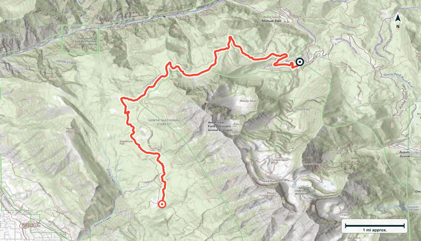
The group covers the main roads and named vehicle spurs between American Fork Canyon and Midway. Lower Mill Canyon and Baker Fork form the American Fork–Snake Creek connection. Reach Timpooneke and Mill Canyon Spring from the Alpine Loop; reach the Polly routes from Pine Canyon Road. Choose separate outings rather than one continuous drive.
PLAN A VERSION THAT FITS
Choose the routes before you open the planner.
Start small, build a day, or load the full collection. Every choice stays editable in the planner.
First dirt
Start with up to two leading easy routes. Use the first route only if the second does not fit today.
- 01Silver Lake Road
- 02Lower Mill Canyon
Day out
Use up to four leading easy or moderate routes. Stop when daylight, energy, or road conditions reach your limit.
- 01Silver Lake Road
- 02Lower Mill Canyon
- 03Baker Fork Road · Snake Creek
- 04Timpooneke Road
Full progression
Load every route in collection order. Later difficult or expert routes remain optional and need separate checks.
- 01Silver Lake Road
- 02Lower Mill Canyon
- 03Baker Fork Road · Snake Creek
- 04Timpooneke Road
- 05Mill Canyon Spring
- 06Samps Hollow Overlook (FR 721)
- 07Cummings Parkway Road
- 08Alta Dry Fork (FR 70198)
- 09Major Evans
- 10Big Flat
- 11Miller Hill
- 12Rattlesnake Hill
- 13Polly Springs
- 14Polly Ridge
- 15Milk Maid
- 16Mary Ellen Gulch
- 17Mill Flat Gulch
- 18Forest Lake
- 19Mineral Basin
ROUTE PROGRESSION
Add one skill at a time.
Drive only the stages that fit your vehicle, experience, weather, and current access. A later stage is not a required finish.
Silver Lake Road
- Route distance
- 4.5 mi
- Time to allow
- 1–2 hours
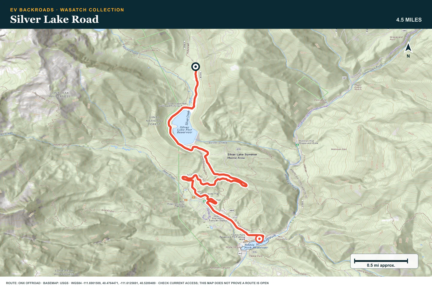
Start with the road from Tibble Fork Reservoir to Silver Lake Flat. Slow down at blind bends and use pullouts before meeting traffic.
Access note: Expect two-way traffic and narrow passing places. Check seasonal gates and the current Pleasant Grove Ranger District notices before travel.
Terrain profile
Elevation along the route
- Total ascent
- +95 ft
- Total descent
- −1,467 ft
Hover or drag to explore the route on the map. Use arrow keys when focused.
- Distance
- —
- Elevation
- —
- Grade
- —
Select a point to see its elevation and grade.
Terrain estimates follow the mapped route; the road surface can differ.
Data sources and accuracy
Elevation from AWS Terrain Tiles, sampled along the published route. These coarser samples show broad changes in terrain; local grades are approximate.
Grade is elevation change divided by horizontal distance. Positive grades climb; negative grades descend. Route alignment and terrain resolution affect every estimate.
Lower Mill Canyon
- Route distance
- 5.2 mi
- Time to allow
- 1–2 hours
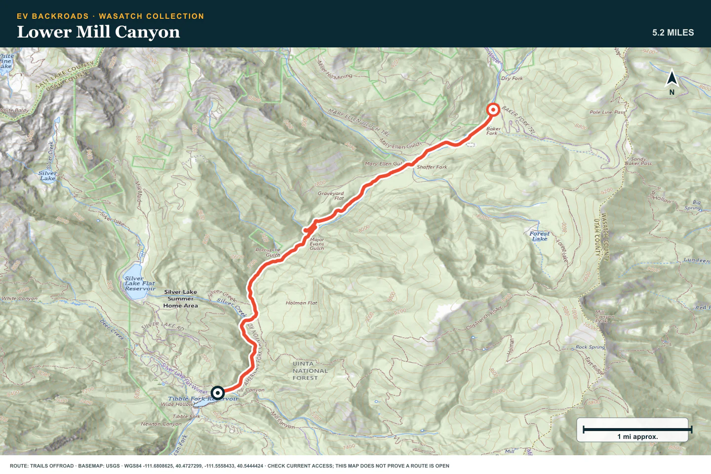
Follow the lower American Fork road into the main trail network. Watch for rough patches and traffic entering from the side roads.
Access note: This is the lower American Fork connection to the Snake Creek network. Check gates, washouts, and current forest road notices before travel.
Terrain profile
Elevation along the route
- Total ascent
- +1,276 ft
- Total descent
- −20 ft
Hover or drag to explore the route on the map. Use arrow keys when focused.
- Distance
- —
- Elevation
- —
- Grade
- —
Select a point to see its elevation and grade.
Terrain estimates follow the mapped route; the road surface can differ.
Data sources and accuracy
Elevation from AWS Terrain Tiles, sampled along the published route. These coarser samples show broad changes in terrain; local grades are approximate.
Grade is elevation change divided by horizontal distance. Positive grades climb; negative grades descend. Route alignment and terrain resolution affect every estimate.
Baker Fork Road · Snake Creek
- Route distance
- 11 mi
- Time to allow
- 2–3 hours
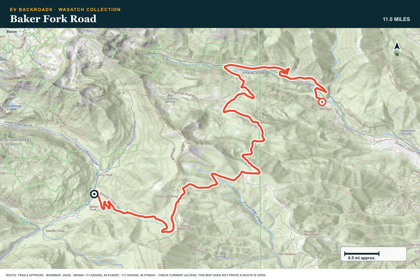
Cross Pole Line Pass on Baker Fork Road, also known as the Snake Creek connection. Confirm the Midway exit before leaving the American Fork side.
Access note: This road is also known as the Snake Creek connection over Pole Line Pass. Check both canyon approaches, snow, and seasonal gates before crossing.
Terrain profile
Elevation along the route
- Total ascent
- +1,427 ft
- Total descent
- −2,285 ft
Hover or drag to explore the route on the map. Use arrow keys when focused.
- Distance
- —
- Elevation
- —
- Grade
- —
Select a point to see its elevation and grade.
Terrain estimates follow the mapped route; the road surface can differ.
Data sources and accuracy
Elevation from AWS Terrain Tiles, sampled along the published route. These coarser samples show broad changes in terrain; local grades are approximate.
Grade is elevation change divided by horizontal distance. Positive grades climb; negative grades descend. Route alignment and terrain resolution affect every estimate.
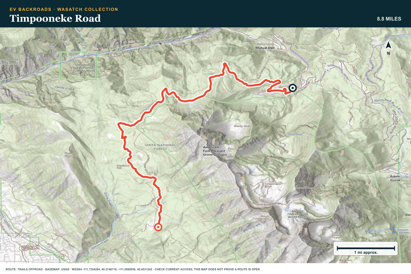
Timpooneke Road
- Route distance
- 8.8 mi
- Time to allow
- Half day
Drive beneath the west face of Mount Timpanogos. The road has little technical rock, but narrow sections run beside steep drops. Keep time and energy for the return.
Access note: The surface is relatively simple, but the road is narrow beside steep drop-offs. Check seasonal gates and turn back before snow or poor visibility.
Terrain profile
Elevation along the route
- Total ascent
- +1,374 ft
- Total descent
- −1,044 ft
Hover or drag to explore the route on the map. Use arrow keys when focused.
- Distance
- —
- Elevation
- —
- Grade
- —
Select a point to see its elevation and grade.
Terrain estimates follow the mapped route; the road surface can differ.
Data sources and accuracy
Elevation from AWS Terrain Tiles, sampled along the published route. These coarser samples show broad changes in terrain; local grades are approximate.
Grade is elevation change divided by horizontal distance. Positive grades climb; negative grades descend. Route alignment and terrain resolution affect every estimate.
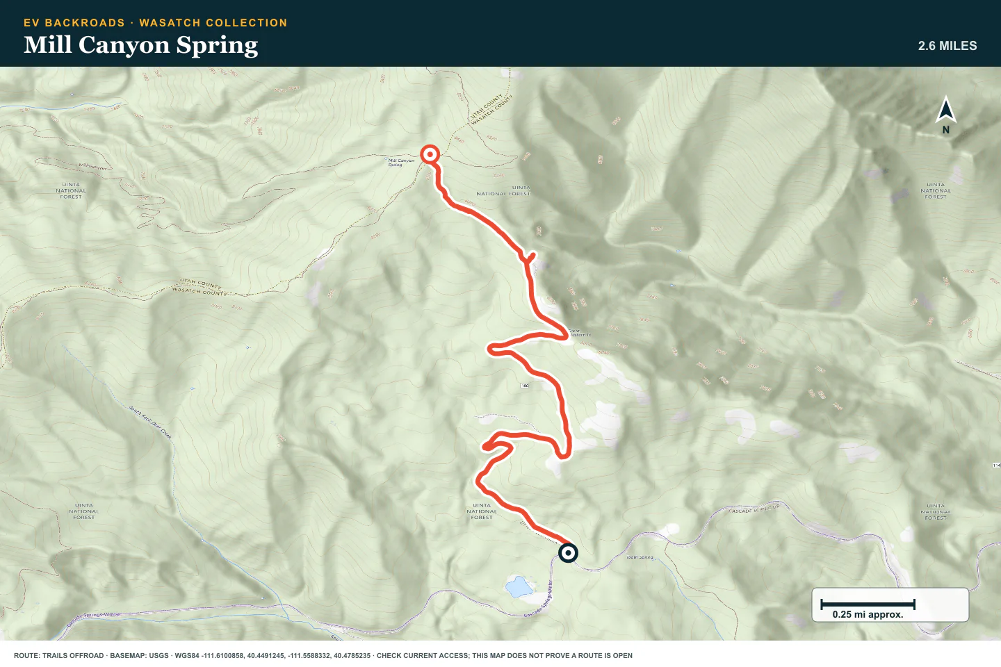
Mill Canyon Spring
- Route distance
- 2.6 mi
- Time to allow
- 1–2 hours
Climb the short road toward Mill Canyon Spring. Choose firm lines around the deep ruts and slow down on loose rock. Use established campsites only.
Access note: Steep grades, deep ruts, and loose rocky climbs need clearance. Check seasonal access and stay on the existing road and established campsites.
Terrain profile
Elevation along the route
- Total ascent
- +980 ft
- Total descent
- −16 ft
Hover or drag to explore the route on the map. Use arrow keys when focused.
- Distance
- —
- Elevation
- —
- Grade
- —
Select a point to see its elevation and grade.
Terrain estimates follow the mapped route; the road surface can differ.
Data sources and accuracy
Elevation from AWS Terrain Tiles, sampled along the published route. These coarser samples show broad changes in terrain; local grades are approximate.
Grade is elevation change divided by horizontal distance. Positive grades climb; negative grades descend. Route alignment and terrain resolution affect every estimate.
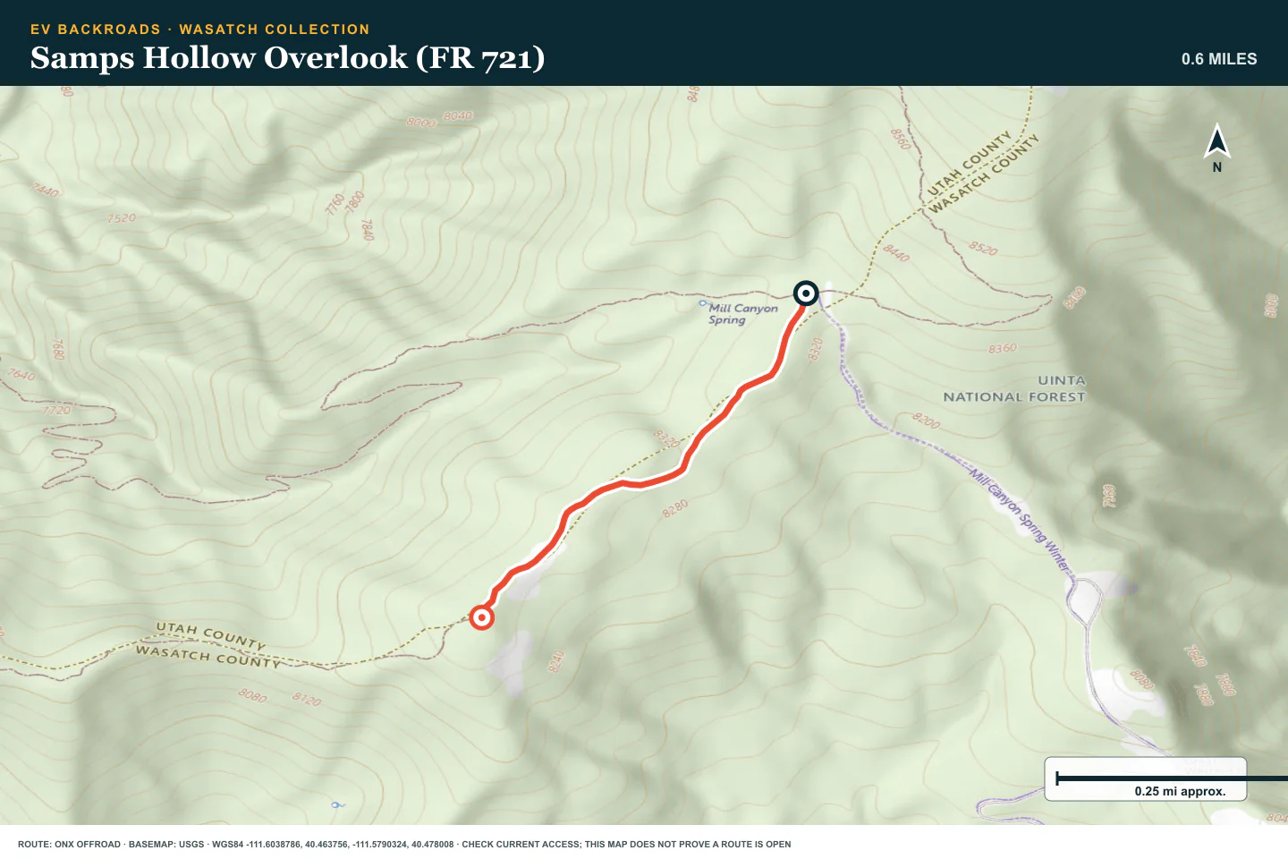
Samps Hollow Overlook (FR 721)
- Route distance
- 0.6 mi
- Time to allow
- 30–60 minutes
Continue from Mill Canyon Spring Road onto the short ridge spur only when it is dry. Inspect deep ruts and stop before mud removes a controlled return.
Access note: This spur starts at Mill Canyon Spring Road. Mud, deep ruts, and uneven ground can change it quickly. Check gates and avoid driving on wet soil.
Terrain profile
Elevation along the route
- Total ascent
- +53 ft
- Total descent
- −29 ft
Hover or drag to explore the route on the map. Use arrow keys when focused.
- Distance
- —
- Elevation
- —
- Grade
- —
Select a point to see its elevation and grade.
Terrain estimates follow the mapped route; the road surface can differ.
Data sources and accuracy
Elevation from AWS Terrain Tiles, sampled along the published route. These coarser samples show broad changes in terrain; local grades are approximate.
Grade is elevation change divided by horizontal distance. Positive grades climb; negative grades descend. Route alignment and terrain resolution affect every estimate.
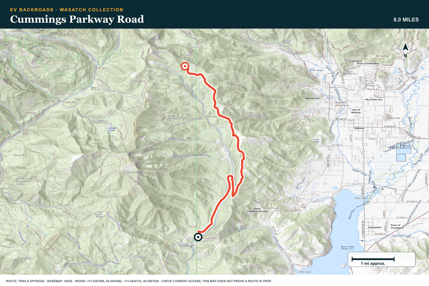
Cummings Parkway Road
- Route distance
- 8 mi
- Time to allow
- Half day
Use this rocky connection on the Midway side as a separate drive. Expect shelf sections and OHV traffic. Confirm the planned exit before starting.
Access note: Expect sustained rock, steep shelf sections, and other OHVs. Check Wasatch Mountain State Park and forest notices before using this connection.
Terrain profile
Elevation along the route
- Total ascent
- +2,401 ft
- Total descent
- −206 ft
Hover or drag to explore the route on the map. Use arrow keys when focused.
- Distance
- —
- Elevation
- —
- Grade
- —
Select a point to see its elevation and grade.
Terrain estimates follow the mapped route; the road surface can differ.
Data sources and accuracy
Elevation from AWS Terrain Tiles, sampled along the published route. These coarser samples show broad changes in terrain; local grades are approximate.
Grade is elevation change divided by horizontal distance. Positive grades climb; negative grades descend. Route alignment and terrain resolution affect every estimate.
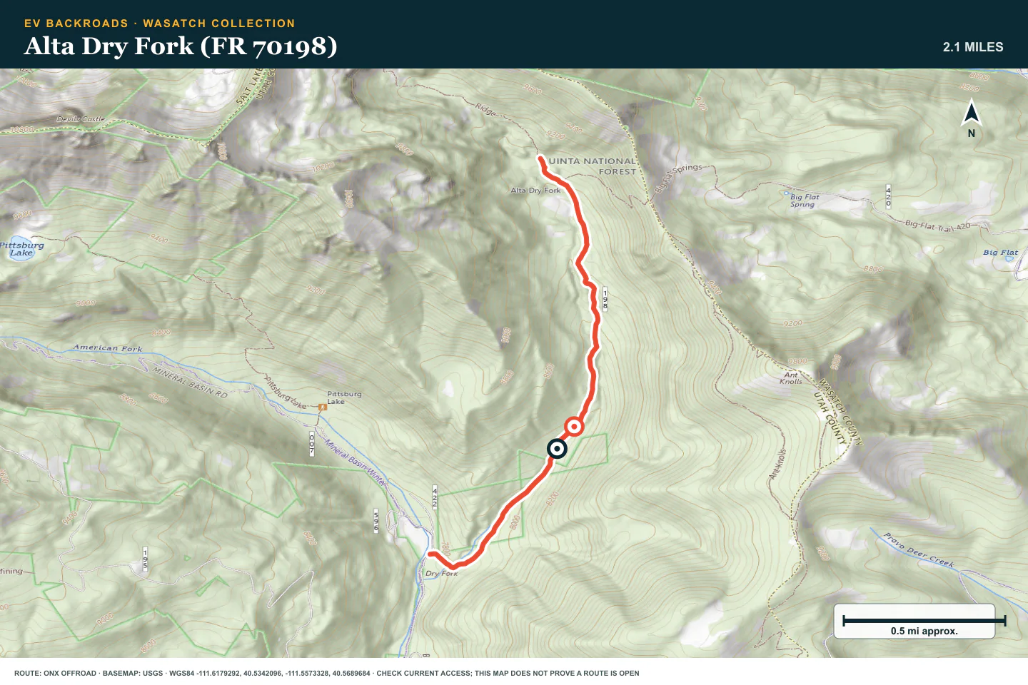
Alta Dry Fork (FR 70198)
- Route distance
- 2.1 mi
- Time to allow
- 1–2 hours
Leave Snake Creek Road for a narrow forest spur. Inspect creek crossings and avoid forcing a wide vehicle through brush. Stop where the motor road ends.
Access note: Expect narrow brush, loose rock, and seasonal creek crossings. Stop at the motor-road endpoint; the continuing Ridge trail is not a vehicle route.
Terrain profile
Elevation along the route
- Total ascent
- +1,242 ft
- Total descent
- −0 ft
Hover or drag to explore the route on the map. Use arrow keys when focused.
- Distance
- —
- Elevation
- —
- Grade
- —
Select a point to see its elevation and grade.
Terrain estimates follow the mapped route; the road surface can differ.
Data sources and accuracy
Elevation from AWS Terrain Tiles, sampled along the published route. These coarser samples show broad changes in terrain; local grades are approximate.
Grade is elevation change divided by horizontal distance. Positive grades climb; negative grades descend. Route alignment and terrain resolution affect every estimate.
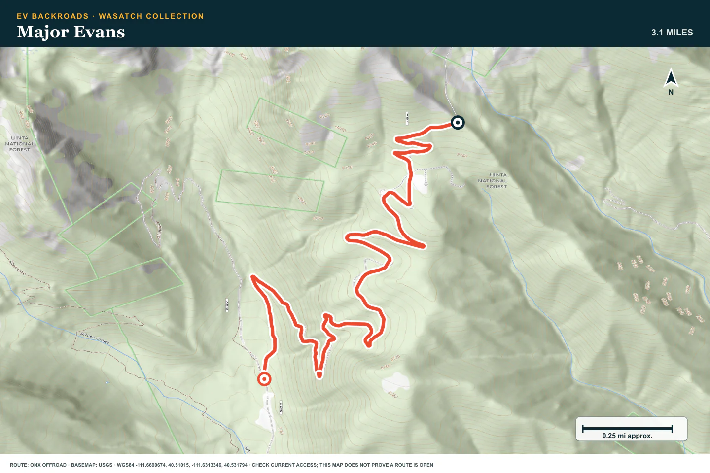
Major Evans
- Route distance
- 3.1 mi
- Time to allow
- 1–2 hours
Take the climbing spur from the Silver Lake area only when the switchbacks fit your vehicle. Inspect rock steps and identify passing places as you climb.
Access note: Tight switchbacks, rock steps, and limited passing room can be difficult for long vehicles. Check the current source and leave room for a safe return.
Terrain profile
Elevation along the route
- Total ascent
- +3 ft
- Total descent
- −1,624 ft
Hover or drag to explore the route on the map. Use arrow keys when focused.
- Distance
- —
- Elevation
- —
- Grade
- —
Select a point to see its elevation and grade.
Terrain estimates follow the mapped route; the road surface can differ.
Data sources and accuracy
Elevation from AWS Terrain Tiles, sampled along the published route. These coarser samples show broad changes in terrain; local grades are approximate.
Grade is elevation change divided by horizontal distance. Positive grades climb; negative grades descend. Route alignment and terrain resolution affect every estimate.
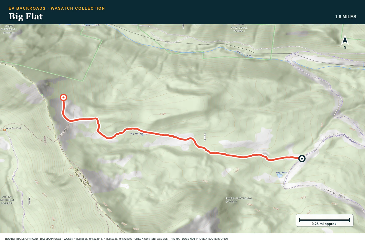
Big Flat
- Route distance
- 1.6 mi
- Time to allow
- 1–2 hours
Leave Snake Creek Road for the short climb to Big Flat. Walk the eroded, off-camber sections before choosing a tire line.
Access note: Erosion has left deep gullies on off-camber ground. Use deliberate tire placement and check seasonal access before leaving Snake Creek Road.
Terrain profile
Elevation along the route
- Total ascent
- +1,053 ft
- Total descent
- −9 ft
Hover or drag to explore the route on the map. Use arrow keys when focused.
- Distance
- —
- Elevation
- —
- Grade
- —
Select a point to see its elevation and grade.
Terrain estimates follow the mapped route; the road surface can differ.
Data sources and accuracy
Elevation from AWS Terrain Tiles, sampled along the published route. These coarser samples show broad changes in terrain; local grades are approximate.
Grade is elevation change divided by horizontal distance. Positive grades climb; negative grades descend. Route alignment and terrain resolution affect every estimate.
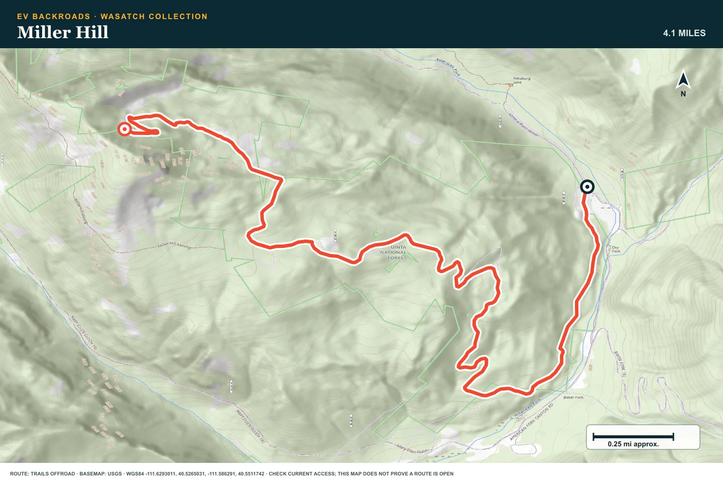
Miller Hill
- Route distance
- 4.1 mi
- Time to allow
- 2–3 hours
Use the Miller Hill route for a longer rocky mountain drive. Stay clear of mine openings and inspect the steeper sections before committing.
Access note: Rock, steep sections, snow, and mine-area hazards can change the drive. Check the live source and forest notices before travel.
Terrain profile
Elevation along the route
- Total ascent
- +2,201 ft
- Total descent
- −92 ft
Hover or drag to explore the route on the map. Use arrow keys when focused.
- Distance
- —
- Elevation
- —
- Grade
- —
Select a point to see its elevation and grade.
Terrain estimates follow the mapped route; the road surface can differ.
Data sources and accuracy
Elevation from AWS Terrain Tiles, sampled along the published route. These coarser samples show broad changes in terrain; local grades are approximate.
Grade is elevation change divided by horizontal distance. Positive grades climb; negative grades descend. Route alignment and terrain resolution affect every estimate.
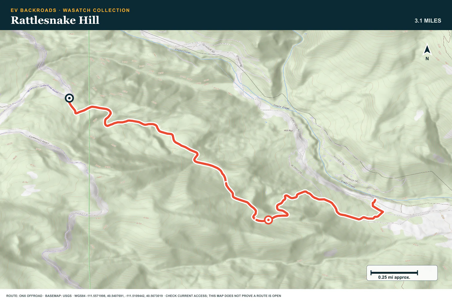
Rattlesnake Hill
- Route distance
- 3.1 mi
- Time to allow
- 1–2 hours
Drive the Snake Creek side route at low speed. Check the larger steps, deep ruts, and exposed edges before climbing or descending.
Access note: Steep climbs, deep ruts, rock steps, and exposed edges require clearance. Check conditions and walk any uncertain line before driving it.
Terrain profile
Elevation along the route
- Total ascent
- +233 ft
- Total descent
- −2,169 ft
Hover or drag to explore the route on the map. Use arrow keys when focused.
- Distance
- —
- Elevation
- —
- Grade
- —
Select a point to see its elevation and grade.
Terrain estimates follow the mapped route; the road surface can differ.
Data sources and accuracy
Elevation from AWS Terrain Tiles, sampled along the published route. These coarser samples show broad changes in terrain; local grades are approximate.
Grade is elevation change divided by horizontal distance. Positive grades climb; negative grades descend. Route alignment and terrain resolution affect every estimate.
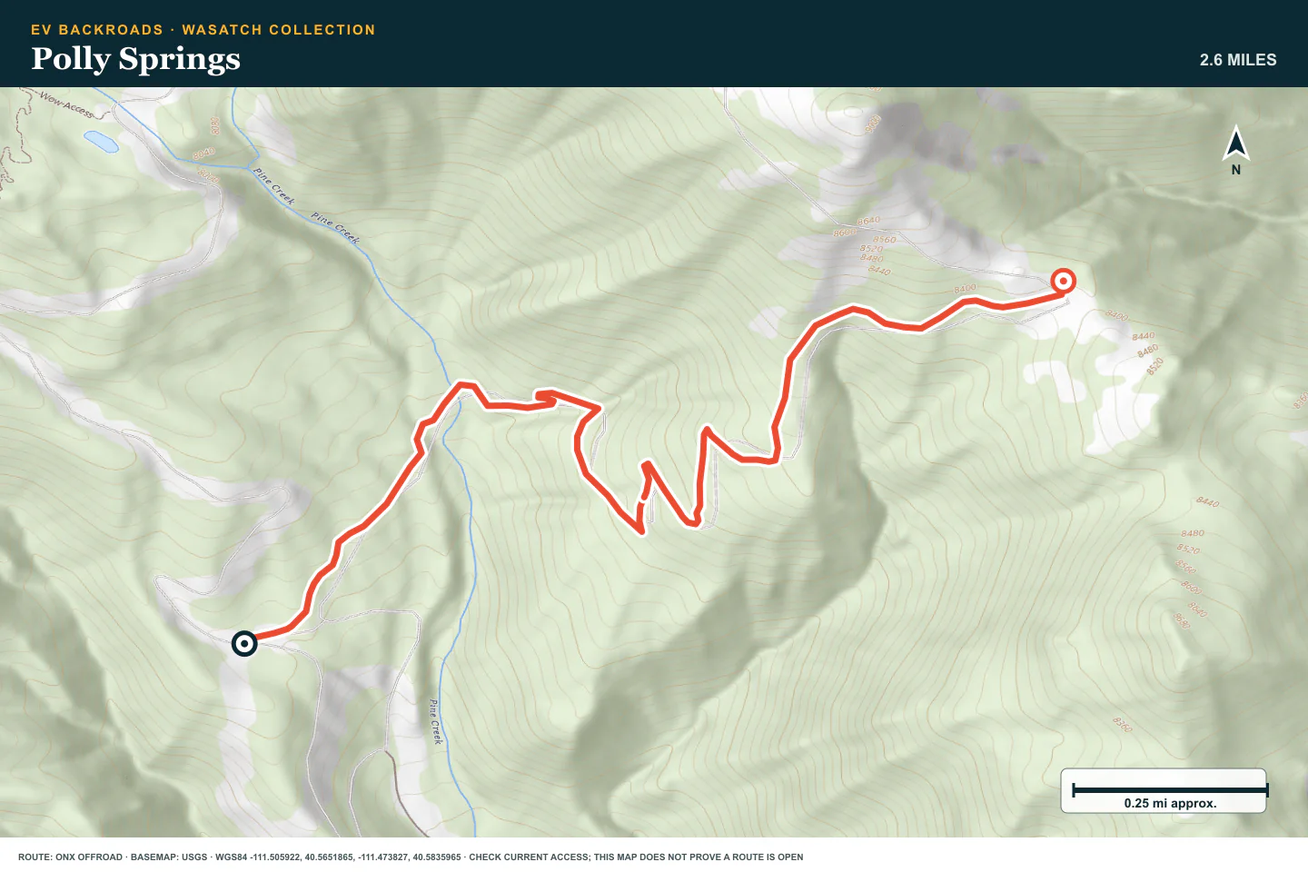
Polly Springs
- Route distance
- 2.6 mi
- Time to allow
- 1–2 hours
From Pine Canyon Road, climb toward Polly Ridge through deep ruts and off-camber rock. Inspect the water crossing and leave a safe downhill line.
Access note: Deep ruts, off-camber rock, and a seasonal water crossing require high clearance. Check Wasatch Mountain State Park access before entering.
Terrain profile
Elevation along the route
- Total ascent
- +1,405 ft
- Total descent
- −15 ft
Hover or drag to explore the route on the map. Use arrow keys when focused.
- Distance
- —
- Elevation
- —
- Grade
- —
Select a point to see its elevation and grade.
Terrain estimates follow the mapped route; the road surface can differ.
Data sources and accuracy
Elevation from AWS Terrain Tiles, sampled along the published route. These coarser samples show broad changes in terrain; local grades are approximate.
Grade is elevation change divided by horizontal distance. Positive grades climb; negative grades descend. Route alignment and terrain resolution affect every estimate.
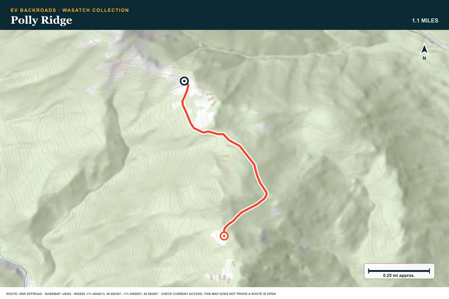
Polly Ridge
- Route distance
- 1.1 mi
- Time to allow
- 1 hour
Continue south from the top of Polly Springs toward the Heber Valley viewpoints. The ridge is simpler than its approach, but it is narrow beside steep drops.
Access note: Reach this ridge through the harder Polly Springs route. The ridge is narrow beside steep drops. Check access and use established turnarounds.
Terrain profile
Elevation along the route
- Total ascent
- +100 ft
- Total descent
- −116 ft
Hover or drag to explore the route on the map. Use arrow keys when focused.
- Distance
- —
- Elevation
- —
- Grade
- —
Select a point to see its elevation and grade.
Terrain estimates follow the mapped route; the road surface can differ.
Data sources and accuracy
Elevation from AWS Terrain Tiles, sampled along the published route. These coarser samples show broad changes in terrain; local grades are approximate.
Grade is elevation change divided by horizontal distance. Positive grades climb; negative grades descend. Route alignment and terrain resolution affect every estimate.
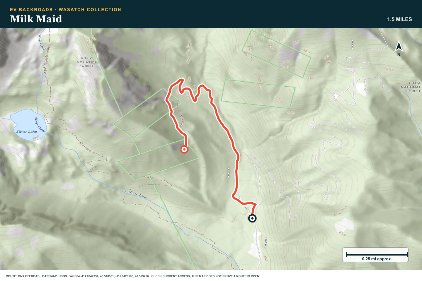
Milk Maid
- Route distance
- 1.5 mi
- Time to allow
- 1–2 hours
Take the rocky Silver Lake-area spur only in stable weather. Loose stone and slides can make the descent harder than the climb.
Access note: Loose rock and slides can change the return after rain. Check the latest report and avoid committing to a climb without a safe descent.
Terrain profile
Elevation along the route
- Total ascent
- +912 ft
- Total descent
- −115 ft
Hover or drag to explore the route on the map. Use arrow keys when focused.
- Distance
- —
- Elevation
- —
- Grade
- —
Select a point to see its elevation and grade.
Terrain estimates follow the mapped route; the road surface can differ.
Data sources and accuracy
Elevation from AWS Terrain Tiles, sampled along the published route. These coarser samples show broad changes in terrain; local grades are approximate.
Grade is elevation change divided by horizontal distance. Positive grades climb; negative grades descend. Route alignment and terrain resolution affect every estimate.
Mary Ellen Gulch
- Route distance
- 4 mi
- Time to allow
- 2–3 hours
Use only the accessible lower part of the gulch. A September 2026 crew report places landslides near waypoint 13. The full source track remains on the map for reference; do not attempt the upper switchbacks.
Access note: A September 8, 2026 Trails Offroad crew report describes landslides near waypoint 13 and an inaccessible summit. Do not attempt the upper switchbacks; check for a newer report before travel.
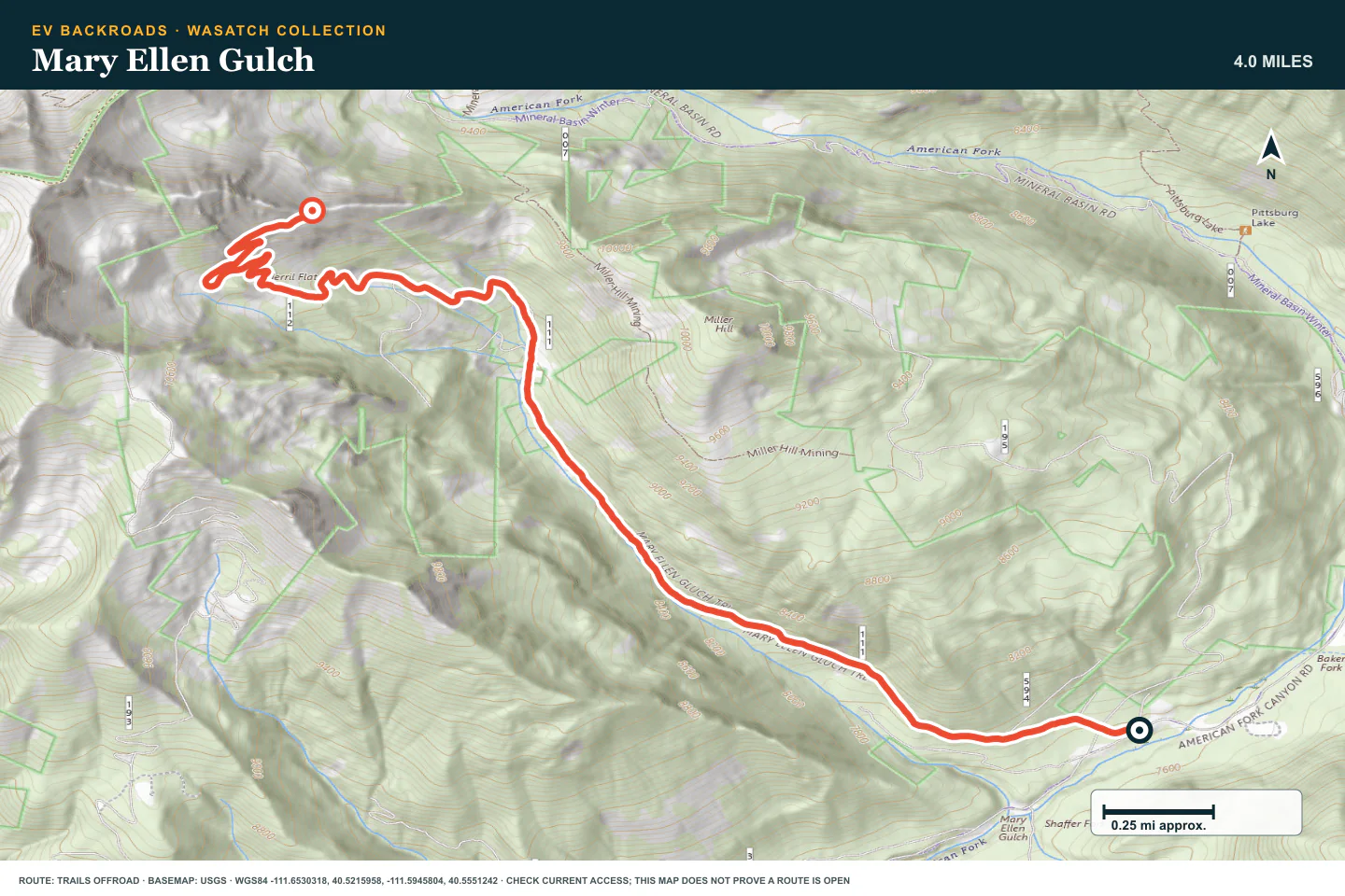
Terrain profile
Elevation along the route
- Total ascent
- +2,824 ft
- Total descent
- −0 ft
Hover or drag to explore the route on the map. Use arrow keys when focused.
- Distance
- —
- Elevation
- —
- Grade
- —
Select a point to see its elevation and grade.
Terrain estimates follow the mapped route; the road surface can differ.
Data sources and accuracy
Elevation from AWS Terrain Tiles, sampled along the published route. These coarser samples show broad changes in terrain; local grades are approximate.
Grade is elevation change divided by horizontal distance. Positive grades climb; negative grades descend. Route alignment and terrain resolution affect every estimate.
Mill Flat Gulch
- Route distance
- 3 mi
- Time to allow
- 2–3 hours
Use this Snake Creek branch only with enough clearance and a recovery plan. Walk the sharp rock gardens and choose a line that protects tires and the underside.
Access note: Long steep grades and sharp rock gardens require careful line choice and recovery planning. Check park and forest access before travel.
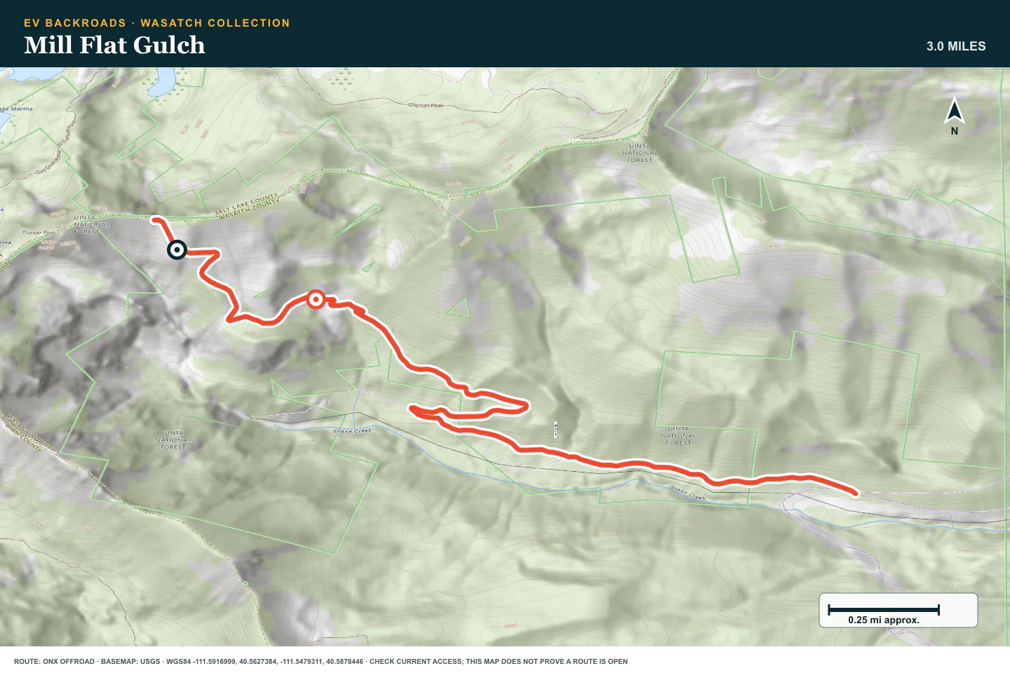
Terrain profile
Elevation along the route
- Total ascent
- +2,526 ft
- Total descent
- −17 ft
Hover or drag to explore the route on the map. Use arrow keys when focused.
- Distance
- —
- Elevation
- —
- Grade
- —
Select a point to see its elevation and grade.
Terrain estimates follow the mapped route; the road surface can differ.
Data sources and accuracy
Elevation from AWS Terrain Tiles, sampled along the published route. These coarser samples show broad changes in terrain; local grades are approximate.
Grade is elevation change divided by horizontal distance. Positive grades climb; negative grades descend. Route alignment and terrain resolution affect every estimate.
Forest Lake
- Route distance
- 1.8 mi
- Time to allow
- 2–3 hours
Climb the rock-filled route toward Forest Lake. Inspect the crossing before entering water and keep enough time to descend over the same obstacles.
Access note: Rock obstacles and the water crossing require clearance and slow driving. Check water depth, current restrictions, and the return route before continuing.
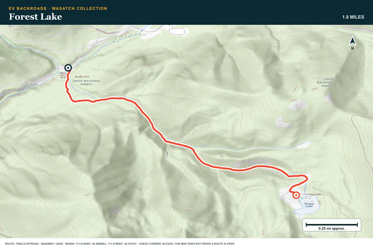
Terrain profile
Elevation along the route
- Total ascent
- +1,018 ft
- Total descent
- −0 ft
Hover or drag to explore the route on the map. Use arrow keys when focused.
- Distance
- —
- Elevation
- —
- Grade
- —
Select a point to see its elevation and grade.
Terrain estimates follow the mapped route; the road surface can differ.
Data sources and accuracy
Elevation from AWS Terrain Tiles, sampled along the published route. These coarser samples show broad changes in terrain; local grades are approximate.
Grade is elevation change divided by horizontal distance. Positive grades climb; negative grades descend. Route alignment and terrain resolution affect every estimate.
Mineral Basin
- Route distance
- 3.3 mi
- Time to allow
- Half day
Keep Mineral Basin as the technical finish. Walk large obstacles and use a spotter where needed. Turn back if the vehicle cannot hold a controlled line.
Access note: Large rock obstacles and changing conditions make this a technical route. Check current forest access and use a vehicle and recovery plan suited to the obstacles.
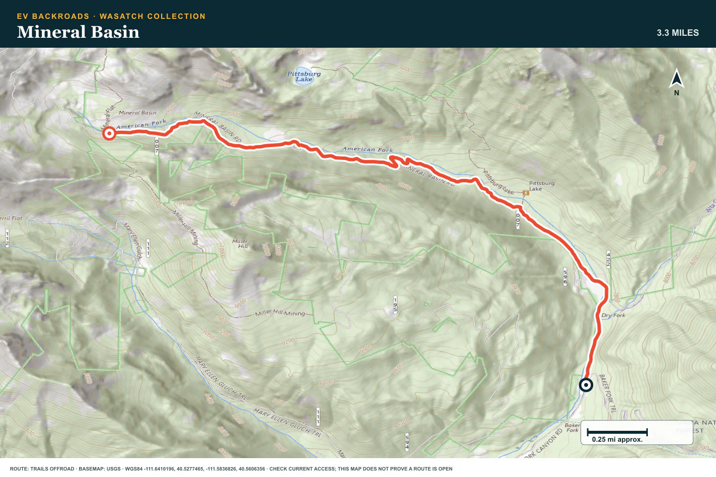
Terrain profile
Elevation along the route
- Total ascent
- +1,664 ft
- Total descent
- −4 ft
Hover or drag to explore the route on the map. Use arrow keys when focused.
- Distance
- —
- Elevation
- —
- Grade
- —
Select a point to see its elevation and grade.
Terrain estimates follow the mapped route; the road surface can differ.
Data sources and accuracy
Elevation from AWS Terrain Tiles, sampled along the published route. These coarser samples show broad changes in terrain; local grades are approximate.
Grade is elevation change divided by horizontal distance. Positive grades climb; negative grades descend. Route alignment and terrain resolution affect every estimate.
ROUTE READINESS
Do seven checks before you leave pavement.
surface
Graded forest roads, shelf roads, loose rock, deep ruts, and technical rock gardens
clearance
High clearance and durable tires for the side trails; choose the easier roads for lower vehicles
remoteness
Towns are nearby, but steep terrain and narrow roads can delay help
charging
Verify charging in Utah Valley or Heber Valley and reserve enough energy for the chosen return
cell Coverage
Download the routes and both canyon approaches before leaving town
weather
Stop for snow, thunderstorms, rising creek water, or rain that softens the road
turnaround
Use the last wide, firm place before an obstacle, slide, or narrow section exceeds your vehicle
BEFORE YOU GO
Make these decisions while you have a signal.
- Check Pleasant Grove Ranger District road notices and its Motor Vehicle Use Map
- Check Wasatch Mountain State Park access for the Midway and Polly routes
- Download the selected routes, set a return reserve, and confirm which canyon exit is available
TURN AROUND WHEN
Follow the limits that you set.
- A closed gate, landslide, or width restriction blocks the route
- Rock, deep ruts, or water exceed the vehicle or driver
- Weather, daylight, or battery use removes the planned return margin
CARRY
Prepare for common problems.
- Tire repair kit, compressor, and suitable recovery equipment
- Offline maps, water, and warm layers
- Satellite communication for the more remote side trails
OPEN THE LIVE MAP
Check the drive home.
See the route with open chargers and road-distance charging gaps. Planned stations do not change current coverage.