EV BACKROADS SPECIAL REPORT · REGENERATIVE DESCENTS
The Longest Free Ride
See what an EV can do on 98 long descents. Regenerative braking can return energy to the battery. A lower speed reduces energy use.
- Roads screened
- 3,600+
- Reference EVs
- 3
- Routes mapped
- 98
A SIMPLE FIRST LESSON
A long downhill is a simple first lesson. Regenerative braking can return energy to the battery. A lower safe speed reduces energy use.
A long paved descent is a simple way to learn how an EV works. The drive motor helps slow the vehicle. It also returns some energy to the battery. A lower speed reduces aerodynamic drag. The energy graph can stay level or go up while the vehicle moves.
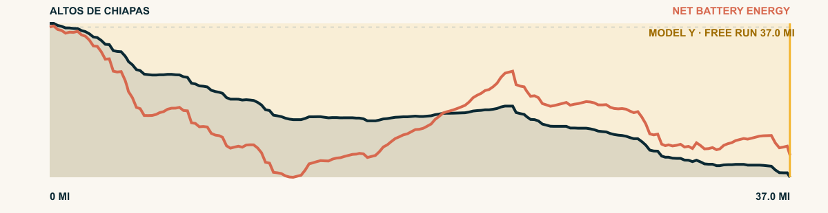
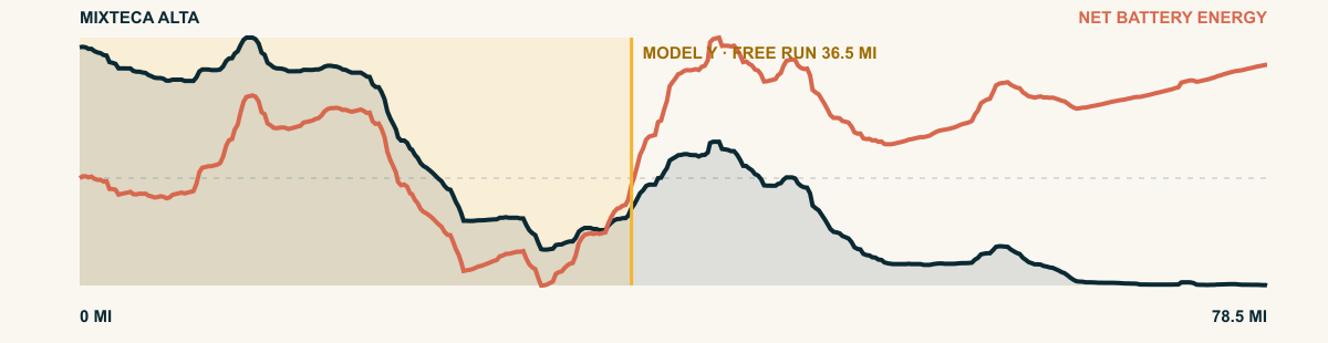
We mapped 98 examples across North America with three 2026 EVs. Do not use these roads as a challenge. Use them to see how the road grade and speed change energy use. Apply this lesson when you plan a simple first off-road trip. “Free miles” is the distance where the model shows that the battery stays at or above its starting charge. “EPA-equivalent miles banked” shows the highest energy surplus at the vehicle’s EPA energy rate. These values compare routes. They do not promise range.
CHOOSE A VEHICLE AND REGION
Choose an EV. See how a downhill changes its range.
Vehicle weight changes how much energy the EV can recover. Speed and road resistance change how much energy it uses. Select a vehicle or region to update the list.
LEARN ACROSS NORTH AMERICA · 98 ROADS
See how hills and speed change EV range.
Compare 98 descents across Mexico, Canada, the Lower 48, and Hawaiʻi. Select a vehicle to see how weight and energy use change the results.
The list uses the 2026 Model Y Premium AWD. “EPA-eq. banked” shows the highest battery surplus at the vehicle's EPA energy rate. These values compare routes. They do not promise range.
Puebla / Veracruz, Mexico90.4 mi33.2 mi14,791 ftView road
Estado de México / Guerrero84.4 mi18.7 mi13,153 ftView road
México / Morelos / Guerrero77.8 mi17.6 mi15,508 ftView road
Veracruz, Mexico65.7 mi16.3 mi10,863 ftView road
California, USA64.6 mi19.4 mi10,726 ftView road
Baja California, Mexico62.3 mi15.4 mi9,783 ftView road
Michoacán, Mexico60.2 mi15.7 mi10,164 ftView road
Michoacán, Mexico59.6 mi13.6 mi8,064 ftView road
Hidalgo, Mexico59.1 mi15.6 mi9,908 ftView road
Hidalgo, Mexico58.2 mi13.1 mi9,897 ftView road
México / Morelos / Guerrero56.1 mi15.2 mi20,659 ftView road
Durango, Mexico51.5 mi21.5 mi17,585 ftView road
Oaxaca, Mexico50.8 mi23.6 mi10,660 ftView road
Colorado, USA49.8 mi16.4 mi9,233 ftView road
Colorado, USA49.3 mi10.3 mi7,919 ftView road
Chiapas, Mexico47.9 mi28.9 mi11,002 ftView road
California, USA45.8 mi13.6 mi11,173 ftView road
Oaxaca, Mexico45.7 mi23 mi11,726 ftView road
Colorado, USA43.9 mi5.4 mi5,674 ftView road
Island of Hawaiʻi43.7 mi19.1 mi9,102 ftView road
Nevada, USA42.8 mi14.3 mi5,270 ftView road
Nuevo León, Mexico42.6 mi10.1 mi10,682 ftView road
New Mexico, USA40.4 mi11.7 mi7,953 ftView road
Michoacán, Mexico40 mi19.1 mi7,644 ftView road
California, USA38.8 mi12.2 mi8,500 ftView road
Pinaleño Mountains, Arizona, USA38.7 mi18.4 mi6,954 ftView road
Jalisco, Mexico38.2 mi23.3 mi8,179 ftView road
Arizona, USA37.7 mi9.5 mi4,388 ftView road
Navajo Nation, Arizona / Utah, USA37.2 mi10.9 mi6,893 ftView road
Chiapas, Mexico37 mi15.1 mi8,493 ftView road
Nevada / California, USA36.2 mi12.2 mi12,748 ftView road
Colorado, USA35.9 mi8.2 mi4,960 ftView road
Oaxaca, Mexico35 mi21.4 mi9,544 ftView road
British Columbia, Canada34.4 mi5.2 mi5,125 ftView road
Veracruz, Mexico33.1 mi20.8 mi10,568 ftView road
Zacatecas / Durango, Mexico31.6 mi19.2 mi16,703 ftView road
Colorado, USA30.9 mi6.8 mi11,114 ftView road
British Columbia, Canada30.3 mi2.5 mi4,137 ftView road
Navajo Nation, Arizona/New Mexico, USA29.2 mi11.1 mi4,927 ftView road
Wyoming, USA26.8 mi11.7 mi5,815 ftView road
British Columbia, Canada21.4 mi11.3 mi4,829 ftView road
Alberta, Canada19.4 mi3.6 mi7,188 ftView road
British Columbia, Canada19.2 mi12.8 mi4,557 ftView road
Vancouver Island, British Columbia, Canada18.6 mi10.4 mi3,835 ftView road
British Columbia, Canada17.6 mi4.1 mi3,314 ftView road
British Columbia, Canada15.5 mi1.1 mi4,180 ftView road
British Columbia, Canada14.9 mi15.4 mi4,698 ftView road
British Columbia, Canada13.9 mi12 mi4,012 ftView road
British Columbia, Canada12.8 mi11 mi3,179 ftView road
British Columbia, Canada12.2 mi17.6 mi5,003 ftView road
British Columbia, Canada10.9 mi6.9 mi2,638 ftView road
British Columbia, Canada10.4 mi10.6 mi3,310 ftView road
British Columbia, Canada7.5 mi4.2 mi1,526 ftView road
British Columbia, Canada7.3 mi3.8 mi3,904 ftView road
British Columbia, Canada6.6 mi1.4 mi6,463 ftView road
British Columbia, Canada5.1 mi1 mi3,327 ftView road
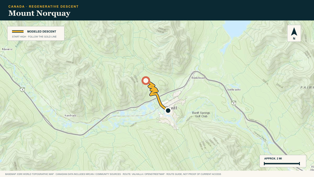
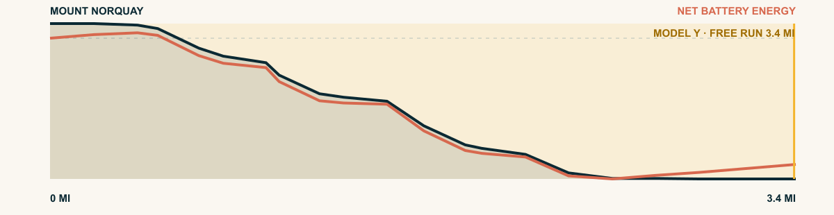
Alberta, Canada3.4 mi3.5 mi1,017 ftView road
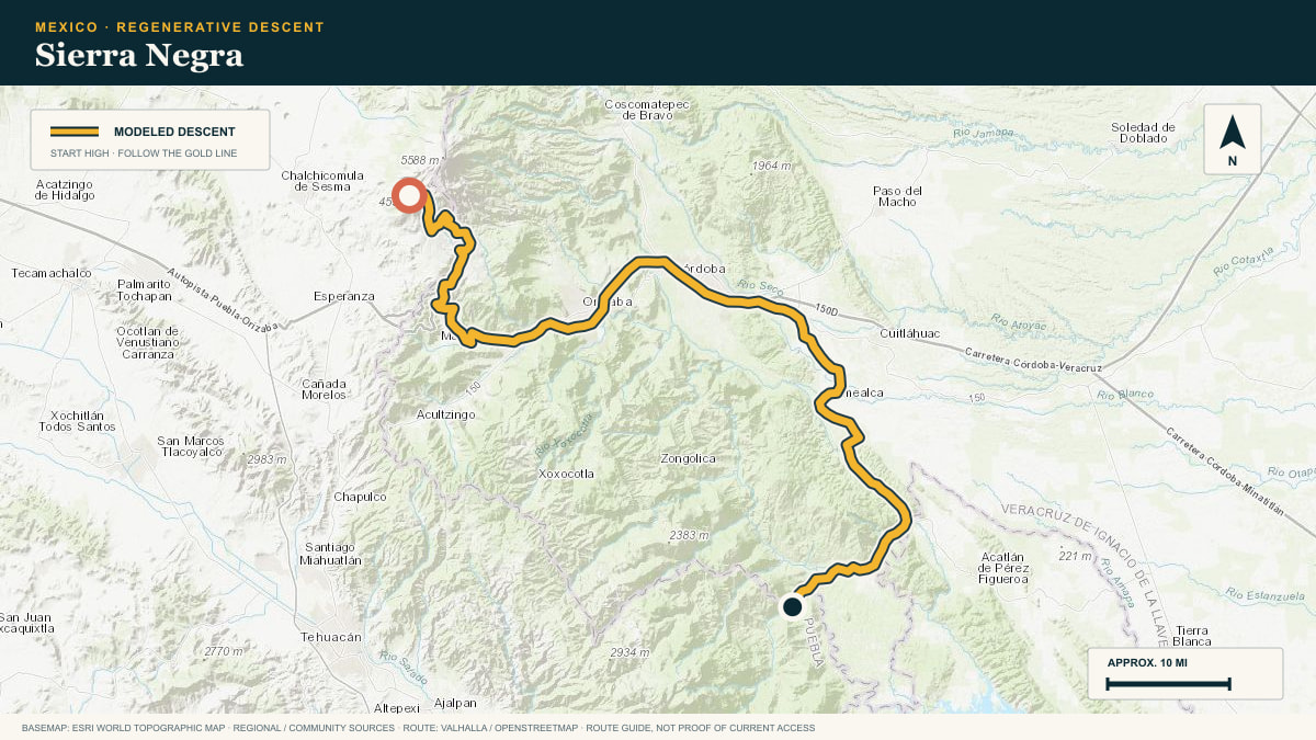
#01 / PUEBLA / VERACRUZ, MEXICO
Sierra Negra
Large Millimeter Telescope Road → MEX-150D corridor
WHAT THIS ROAD SHOWS
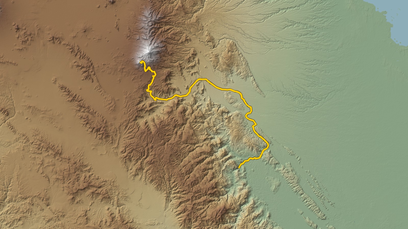
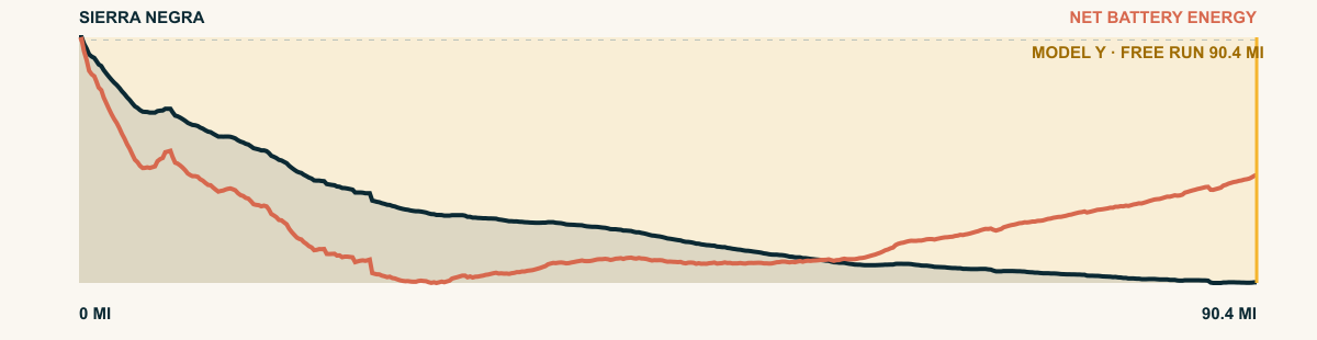
From the observatory road high on Sierra Negra, the pavement falls through fir forest, barrancas, and sugarcane before reaching the Veracruz lowlands. Few roads cross so much climate and elevation in one descent.
For the 2026 Model Y Premium AWD, the model shows that the battery stays at or above its starting charge for 90.4 of 90.4 road miles. The highest energy surplus is 9.1 kWh. This equals about 33.2 miles at the EPA energy rate. The result shows how the road grade and speed can reduce net energy use.
- Battery-hold miles
- 90.4
- Route length
- 90.4 mi
- Share of route
- 100%
- Total descent
- 14,791 ft
- Peak surplus
- 9.1 kWh
- EPA-eq. banked
- 33.2 mi
#02 / ESTADO DE MÉXICO / GUERRERO
Nevado de Toluca
Raíces → Tierra Caliente
WHAT THIS ROAD SHOWS
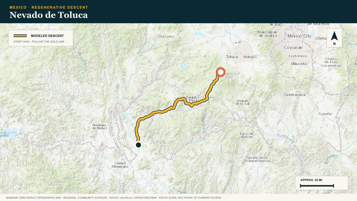
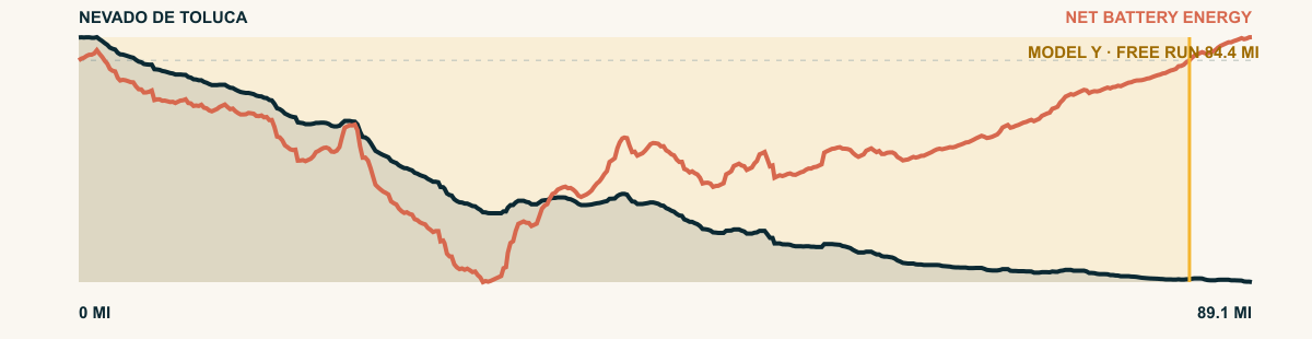
Off the shoulder of the great extinct volcano, the road falls south through successive mountain valleys into the hot country of the Balsas basin.
For the 2026 Model Y Premium AWD, the model shows that the battery stays at or above its starting charge for 84.4 of 89.1 road miles. The highest energy surplus is 5.1 kWh. This equals about 18.7 miles at the EPA energy rate. The result shows how the road grade and speed can reduce net energy use.
- Battery-hold miles
- 84.4
- Route length
- 89.1 mi
- Share of route
- 95%
- Total descent
- 13,153 ft
- Peak surplus
- 5.1 kWh
- EPA-eq. banked
- 18.7 mi
#03 / MÉXICO / MORELOS / GUERRERO
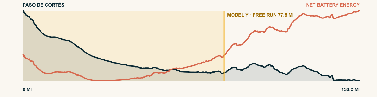
Paso de Cortés
Between Popocatépetl and Iztaccíhuatl → Balsas Valley
WHAT THIS ROAD SHOWS
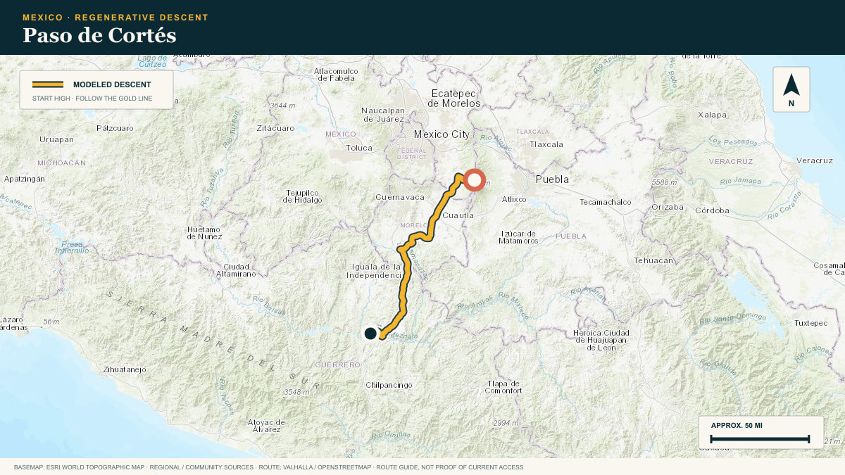
Starting in the volcanic saddle between Popocatépetl and Iztaccíhuatl, this marathon route steps down terrace after terrace into the hot Balsas depression.
For the 2026 Model Y Premium AWD, the model shows that the battery stays at or above its starting charge for 77.8 of 130.2 road miles. The highest energy surplus is 4.8 kWh. This equals about 17.6 miles at the EPA energy rate. The result shows how the road grade and speed can reduce net energy use.
- Battery-hold miles
- 77.8
- Route length
- 130.2 mi
- Share of route
- 60%
- Total descent
- 15,508 ft
- Peak surplus
- 4.8 kWh
- EPA-eq. banked
- 17.6 mi
#04 / VERACRUZ, MEXICO
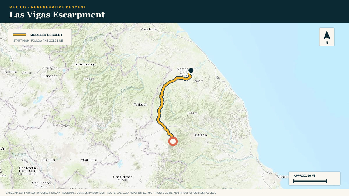
Las Vigas Escarpment
MEX-140 · Las Vigas → Nautla plain
WHAT THIS ROAD SHOWS
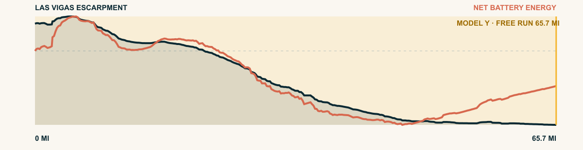
A parallel plunge to its neighbor at Perote, this road leaves the highland plain at Las Vigas and follows the escarpment toward Misantla and the Gulf coast.
For the 2026 Model Y Premium AWD, the model shows that the battery stays at or above its starting charge for 65.7 of 65.7 road miles. The highest energy surplus is 4.5 kWh. This equals about 16.3 miles at the EPA energy rate. The result shows how the road grade and speed can reduce net energy use.
- Battery-hold miles
- 65.7
- Route length
- 65.7 mi
- Share of route
- 100%
- Total descent
- 10,863 ft
- Peak surplus
- 4.5 kWh
- EPA-eq. banked
- 16.3 mi
#05 / CALIFORNIA, USA
Sherman Pass
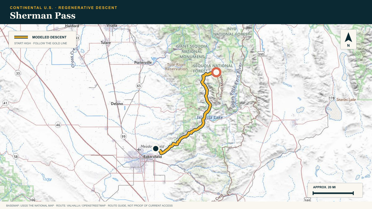
Sherman Pass Road into the Kern River canyon
WHAT THIS ROAD SHOWS
The southern Sierra’s quiet crossing. From 9,200 ft the road corkscrews off the Kern Plateau and follows the river’s hot canyon down, 13,300 cumulative feet of it.
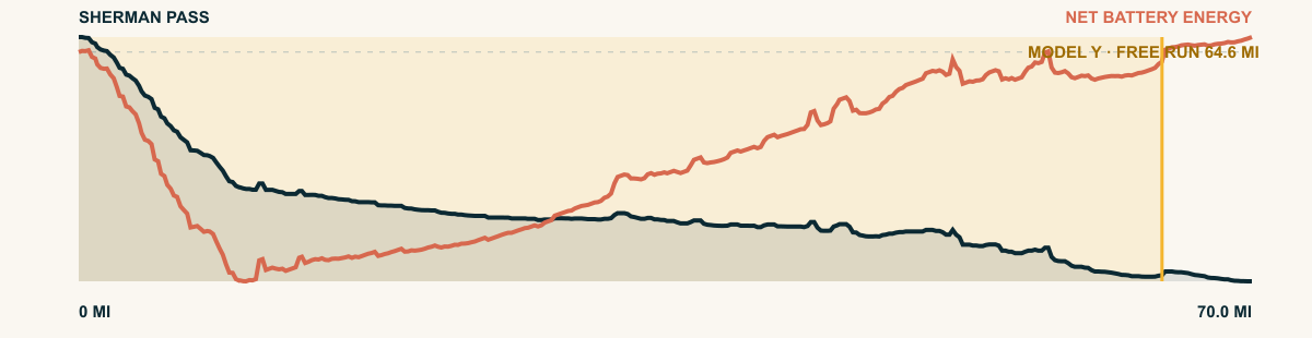
For the 2026 Model Y Premium AWD, the model shows that the battery stays at or above its starting charge for 64.6 of 70 road miles. The highest energy surplus is 5.3 kWh. This equals about 19.4 miles at the EPA energy rate. The result shows how the road grade and speed can reduce net energy use.
- Battery-hold miles
- 64.6
- Route length
- 70 mi
- Share of route
- 92%
- Total descent
- 10,726 ft
- Peak surplus
- 5.3 kWh
- EPA-eq. banked
- 19.4 mi
#06 / COLORADO, USA
Pikes Peak
Pikes Peak Highway → Fountain Valley
WHAT THIS ROAD SHOWS
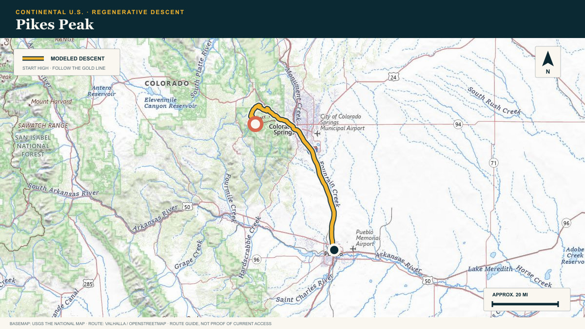
From the summit highway, the road drops past Colorado Springs and follows the Fountain Valley toward Pueblo, carrying the scale of Pikes Peak into the open plains.
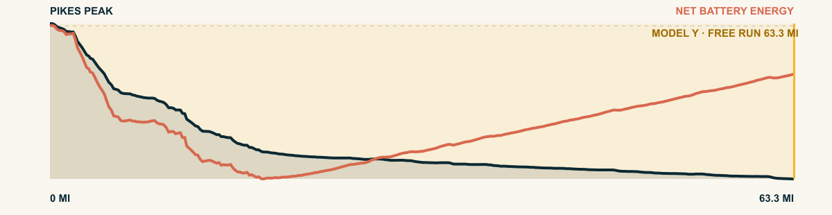
For the 2026 Model Y Premium AWD, the model shows that the battery stays at or above its starting charge for 63.3 of 63.3 road miles. The highest energy surplus is 6.5 kWh. This equals about 23.8 miles at the EPA energy rate. The result shows how the road grade and speed can reduce net energy use.
- Battery-hold miles
- 63.3
- Route length
- 63.3 mi
- Share of route
- 100%
- Total descent
- 8,755 ft
- Peak surplus
- 6.5 kWh
- EPA-eq. banked
- 23.8 mi
#07 / BAJA CALIFORNIA, MEXICO
San Pedro Mártir
Observatory Road → Pacific slope
WHAT THIS ROAD SHOWS
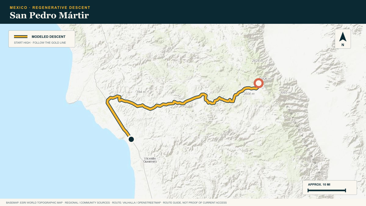
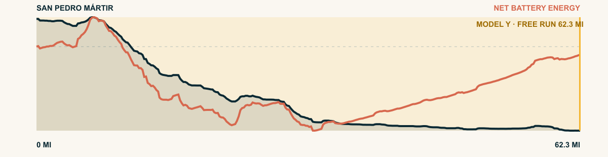
Baja’s granite spine falls away west from the observatory road, passing through Jeffrey pine and chaparral before reaching the irrigated coastal plain near San Telmo.
For the 2026 Model Y Premium AWD, the model shows that the battery stays at or above its starting charge for 62.3 of 62.3 road miles. The highest energy surplus is 4.2 kWh. This equals about 15.4 miles at the EPA energy rate. The result shows how the road grade and speed can reduce net energy use.
- Battery-hold miles
- 62.3
- Route length
- 62.3 mi
- Share of route
- 100%
- Total descent
- 9,783 ft
- Peak surplus
- 4.2 kWh
- EPA-eq. banked
- 15.4 mi
#08 / MICHOACÁN, MEXICO
Mil Cumbres
MEX-15 libre, the old Toluca–Morelia highway
WHAT THIS ROAD SHOWS
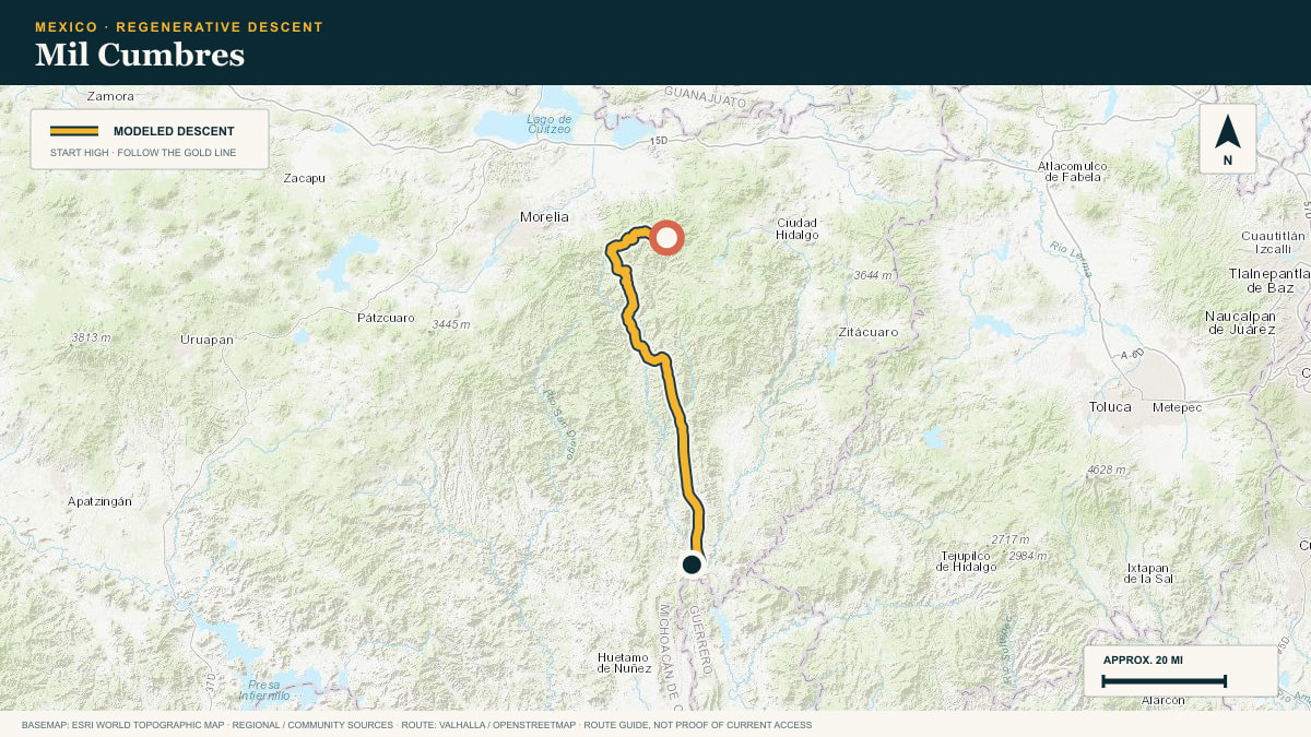
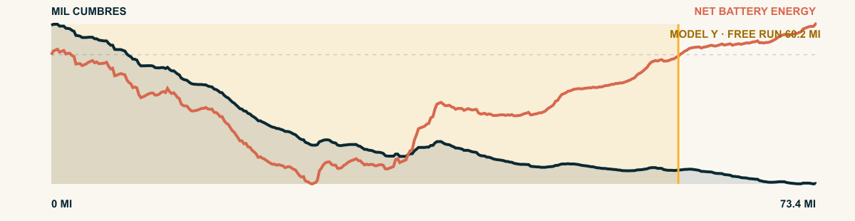
Ridge after ridge of pine-covered volcanic highland gives Mil Cumbres its name. Taken westbound, the road follows a long, folded descent toward Morelia.
For the 2026 Model Y Premium AWD, the model shows that the battery stays at or above its starting charge for 60.2 of 73.4 road miles. The highest energy surplus is 4.3 kWh. This equals about 15.7 miles at the EPA energy rate. The result shows how the road grade and speed can reduce net energy use.
- Battery-hold miles
- 60.2
- Route length
- 73.4 mi
- Share of route
- 82%
- Total descent
- 10,164 ft
- Peak surplus
- 4.3 kWh
- EPA-eq. banked
- 15.7 mi
#09 / MICHOACÁN, MEXICO
Sierra de Tacámbaro
the Carretera Virrey toward tierra caliente
WHAT THIS ROAD SHOWS
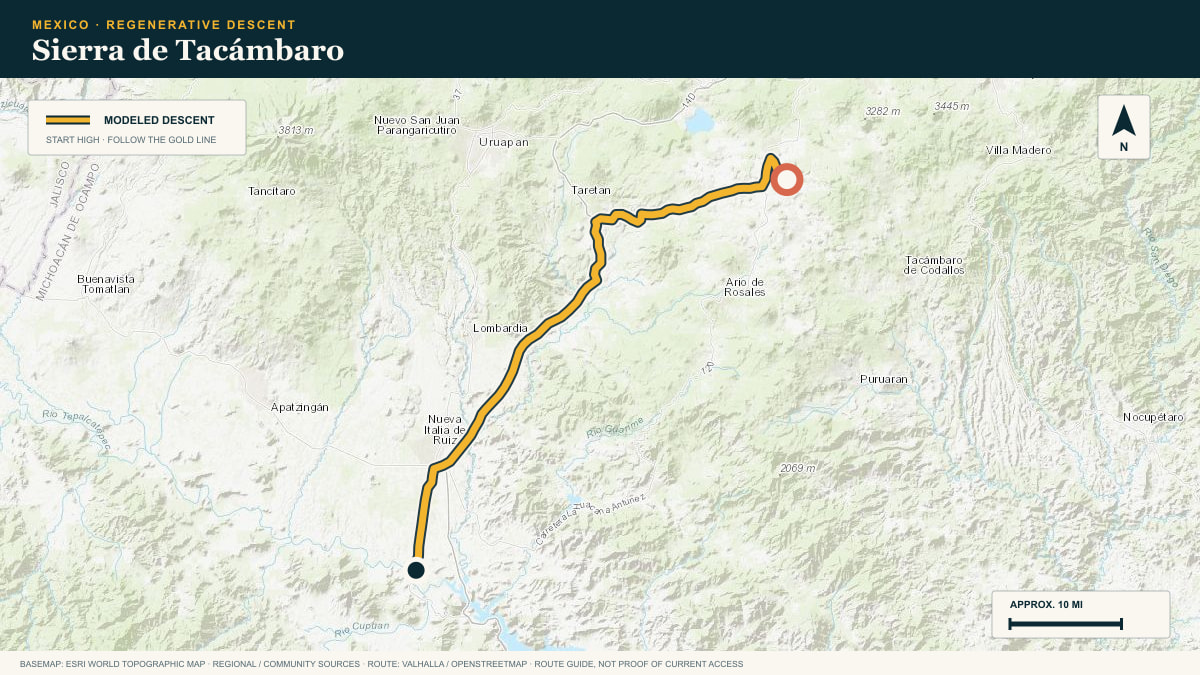
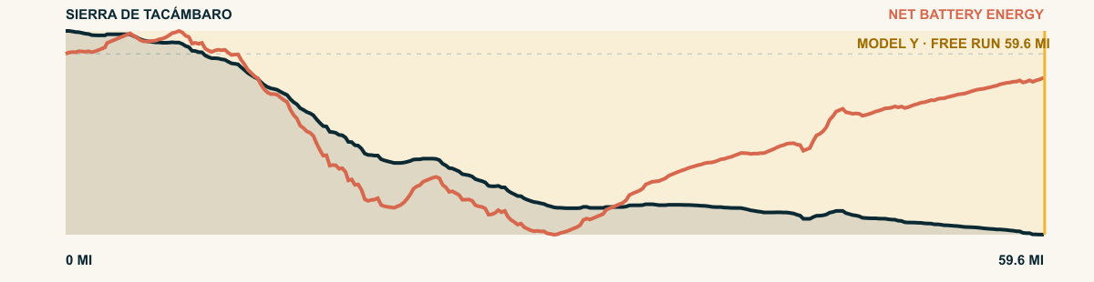
Avocado-and-pine highlands ending in a step. Off the volcanic shoulder south of Pátzcuaro the road drops 9,600 cumulative feet toward the hot country.
For the 2026 Model Y Premium AWD, the model shows that the battery stays at or above its starting charge for 59.6 of 59.6 road miles. The highest energy surplus is 3.7 kWh. This equals about 13.6 miles at the EPA energy rate. The result shows how the road grade and speed can reduce net energy use.
- Battery-hold miles
- 59.6
- Route length
- 59.6 mi
- Share of route
- 100%
- Total descent
- 8,064 ft
- Peak surplus
- 3.7 kWh
- EPA-eq. banked
- 13.6 mi
#10 / CALIFORNIA, USA
Lassen
Lassen Peak Highway (CA-89)
WHAT THIS ROAD SHOWS
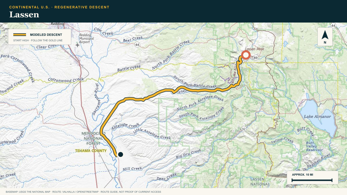
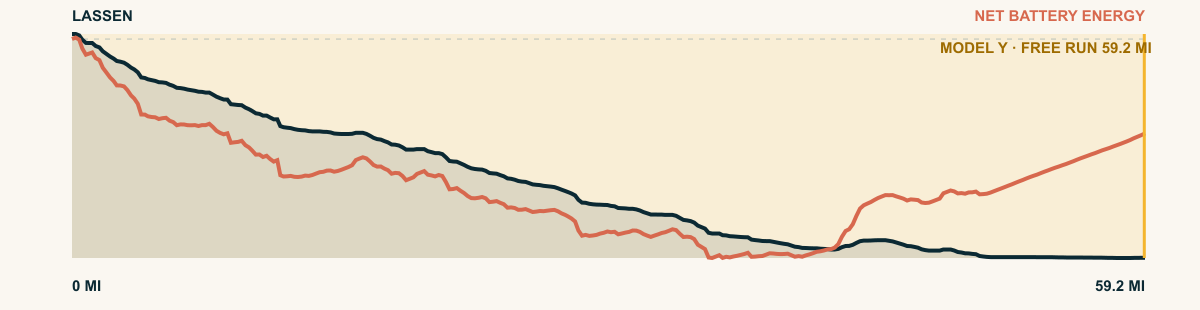
The southernmost Cascade volcano, and the highest highway pass in the range. From the park’s 8,500-ft rim the descent runs off the volcanic tableland toward the Central Valley’s edge.
For the 2026 Model Y Premium AWD, the model shows that the battery stays at or above its starting charge for 59.2 of 59.2 road miles. The highest energy surplus is 4.3 kWh. This equals about 15.8 miles at the EPA energy rate. The result shows how the road grade and speed can reduce net energy use.
- Battery-hold miles
- 59.2
- Route length
- 59.2 mi
- Share of route
- 100%
- Total descent
- 8,755 ft
- Peak surplus
- 4.3 kWh
- EPA-eq. banked
- 15.8 mi
#11 / HIDALGO, MEXICO
Zacualtipán
MEX-105 off the Zacualtipán plateau into the Huasteca
WHAT THIS ROAD SHOWS
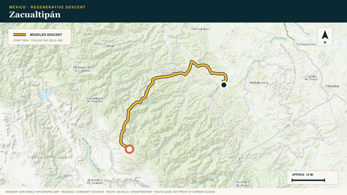
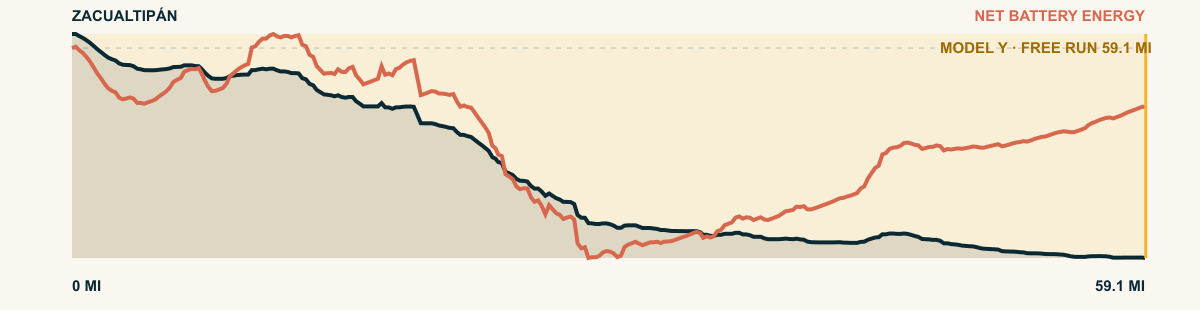
The Pachuca–Huejutla highway is Hidalgo’s great vertical road. This stretch takes the plateau edge in a near-continuous descent, fog belt to tropics.
For the 2026 Model Y Premium AWD, the model shows that the battery stays at or above its starting charge for 59.1 of 59.1 road miles. The highest energy surplus is 4.3 kWh. This equals about 15.6 miles at the EPA energy rate. The result shows how the road grade and speed can reduce net energy use.
- Battery-hold miles
- 59.1
- Route length
- 59.1 mi
- Share of route
- 100%
- Total descent
- 9,908 ft
- Peak surplus
- 4.3 kWh
- EPA-eq. banked
- 15.6 mi
#12 / HIDALGO, MEXICO
Sierra de Tulancingo
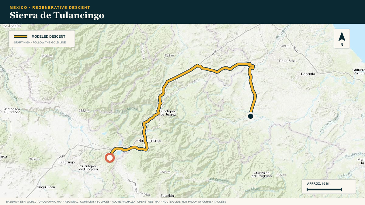
off the Agua Blanca highlands toward the Huasteca
WHAT THIS ROAD SHOWS
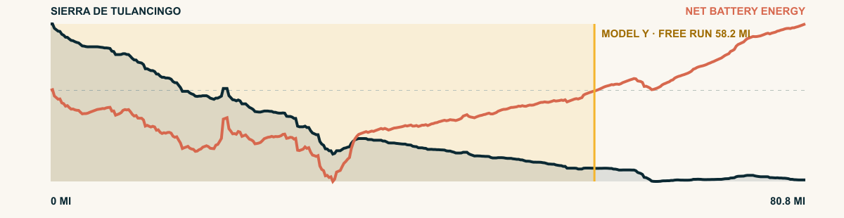
Where the Altiplano breaks toward the Gulf, everything is downhill. From the cool Agua Blanca pines the road sheds 13,500 cumulative feet into the green Huasteca.
For the 2026 Model Y Premium AWD, the model shows that the battery stays at or above its starting charge for 58.2 of 80.8 road miles. The highest energy surplus is 3.6 kWh. This equals about 13.1 miles at the EPA energy rate. The result shows how the road grade and speed can reduce net energy use.
- Battery-hold miles
- 58.2
- Route length
- 80.8 mi
- Share of route
- 72%
- Total descent
- 9,897 ft
- Peak surplus
- 3.6 kWh
- EPA-eq. banked
- 13.1 mi
#13 / VERACRUZ, MEXICO
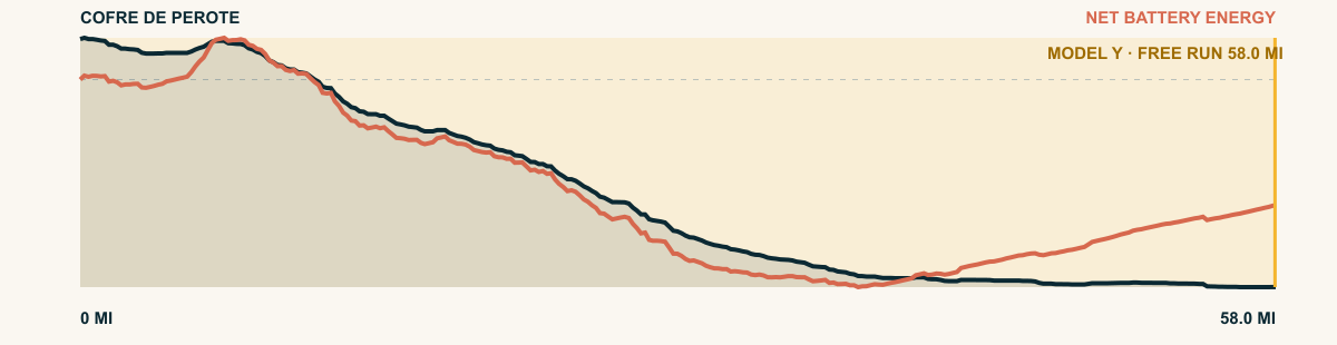
Cofre de Perote
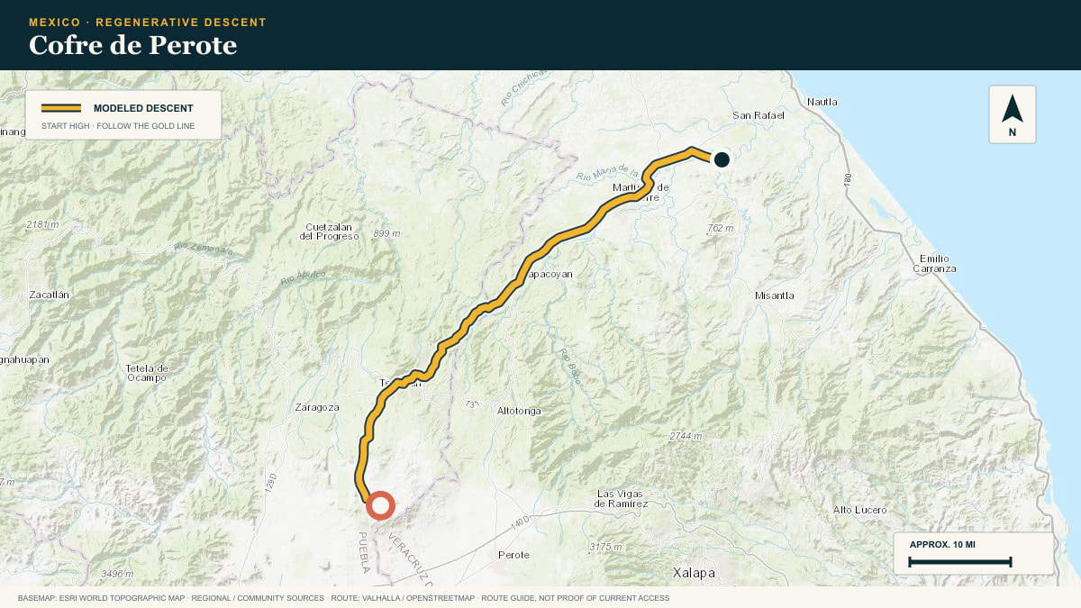
Altotonga–Tlapacoyan descent
WHAT THIS ROAD SHOWS
The road leaves the cold pine forest on the north side of Cofre de Perote. It follows the eastern escarpment toward orange groves on the Gulf plain.
For the 2026 Model Y Premium AWD, the model shows that the battery stays at or above its starting charge for 58 of 58 road miles. The highest energy surplus is 6.1 kWh. This equals about 22.2 miles at the EPA energy rate. The result shows how the road grade and speed can reduce net energy use.
- Battery-hold miles
- 58
- Route length
- 58 mi
- Share of route
- 100%
- Total descent
- 10,486 ft
- Peak surplus
- 6.1 kWh
- EPA-eq. banked
- 22.2 mi
#14 / MÉXICO / MORELOS / GUERRERO
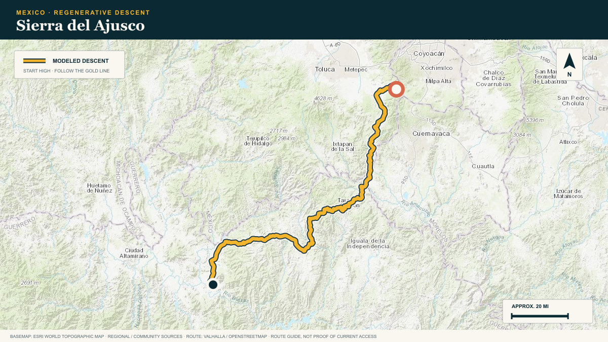
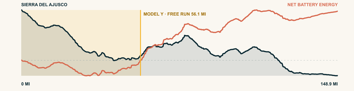
Sierra del Ajusco
Chichinautzin highlands → Tierra Caliente
WHAT THIS ROAD SHOWS
From the volcanic highlands on Mexico City’s southern rim, this long route descends in stages into the furnace of the Balsas Depression.
For the 2026 Model Y Premium AWD, the model shows that the battery stays at or above its starting charge for 56.1 of 148.9 road miles. The highest energy surplus is 4.2 kWh. This equals about 15.2 miles at the EPA energy rate. The result shows how the road grade and speed can reduce net energy use.
- Battery-hold miles
- 56.1
- Route length
- 148.9 mi
- Share of route
- 38%
- Total descent
- 20,659 ft
- Peak surplus
- 4.2 kWh
- EPA-eq. banked
- 15.2 mi
#15 / MONTANA / WYOMING, USA
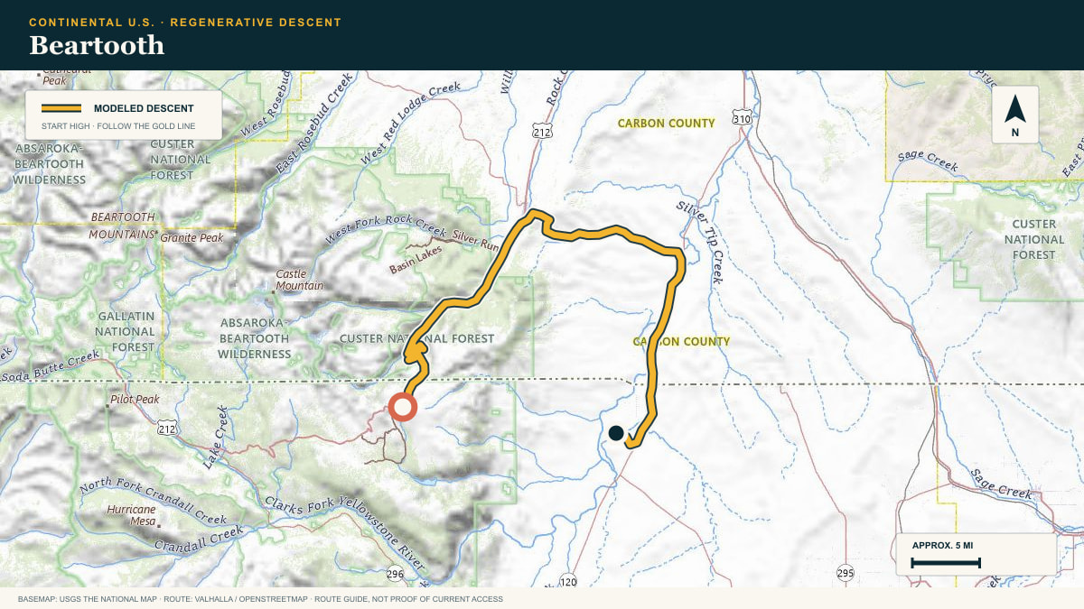
Beartooth
Beartooth Highway · US-212
WHAT THIS ROAD SHOWS
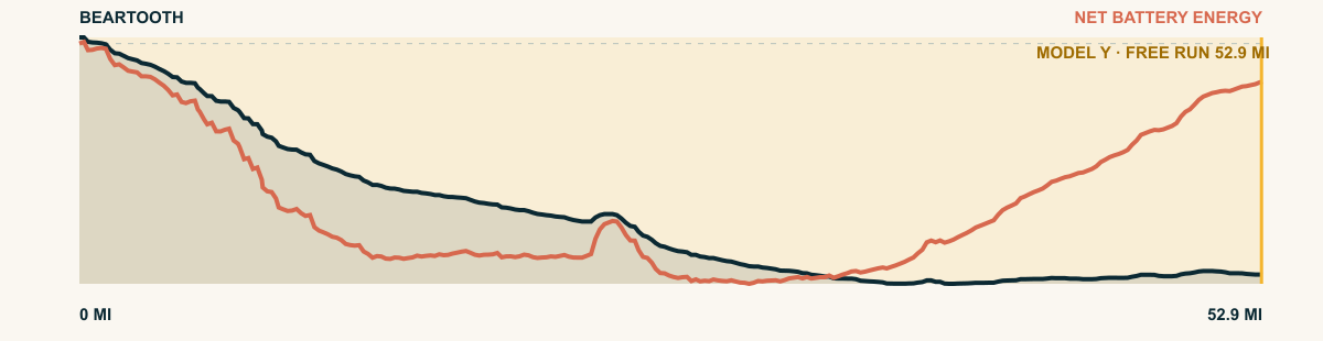
From the tundra benches near Beartooth Pass, the highway plunges off the plateau’s eastern escarpment into the Clarks Fork valley, with open switchbacks stacked above the basin.
For the 2026 Model Y Premium AWD, the model shows that the battery stays at or above its starting charge for 52.9 of 52.9 road miles. The highest energy surplus is 3.9 kWh. This equals about 14.1 miles at the EPA energy rate. The result shows how the road grade and speed can reduce net energy use.
- Battery-hold miles
- 52.9
- Route length
- 52.9 mi
- Share of route
- 100%
- Total descent
- 7,490 ft
- Peak surplus
- 3.9 kWh
- EPA-eq. banked
- 14.1 mi
#16 / DURANGO, MEXICO
Sierra del Mezquital
DGO-23, Mezquital toward Huazamota
WHAT THIS ROAD SHOWS
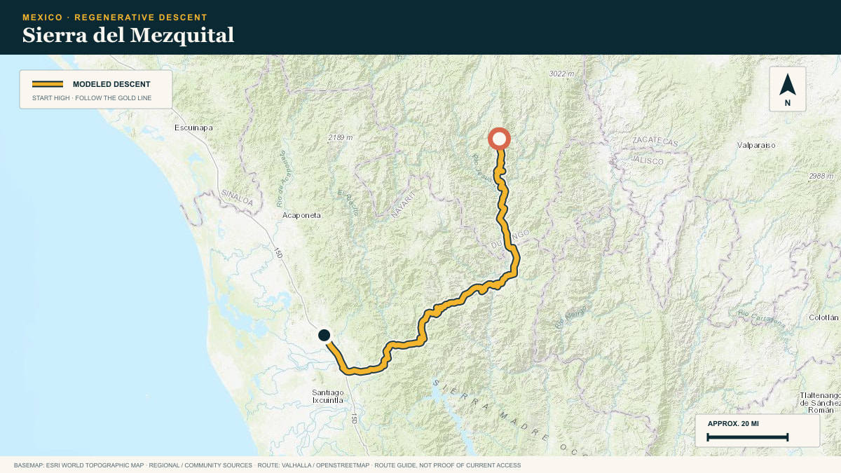
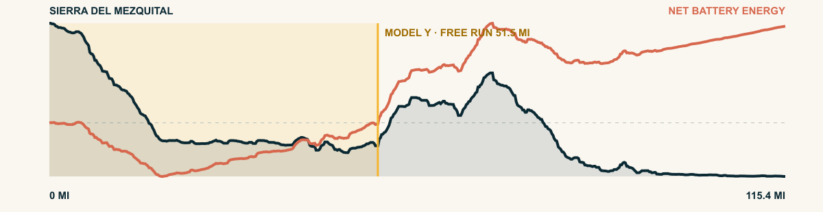
South of Durango city the sierra shatters into barrancas. The highway to Huazamota rides the grain of that country downward for a hundred and forty miles.
For the 2026 Model Y Premium AWD, the model shows that the battery stays at or above its starting charge for 51.5 of 115.4 road miles. The highest energy surplus is 5.9 kWh. This equals about 21.5 miles at the EPA energy rate. The result shows how the road grade and speed can reduce net energy use.
- Battery-hold miles
- 51.5
- Route length
- 115.4 mi
- Share of route
- 45%
- Total descent
- 17,585 ft
- Peak surplus
- 5.9 kWh
- EPA-eq. banked
- 21.5 mi
#17 / OAXACA, MEXICO
Sierra Mixe
the Mixe highlands toward the Papaloapan lowlands
WHAT THIS ROAD SHOWS
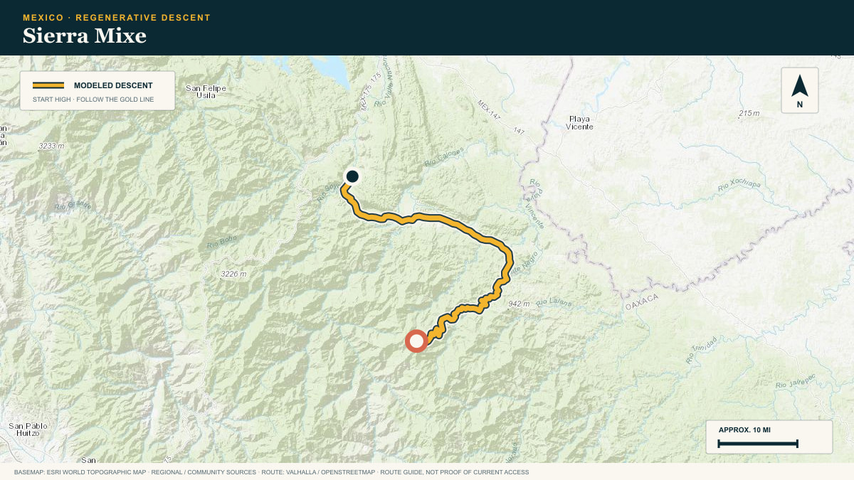
East of the Sierra Juárez the Mixe country falls toward the Gulf in green staircases. Nearly 15,000 cumulative feet of descent through coffee and cloud forest.
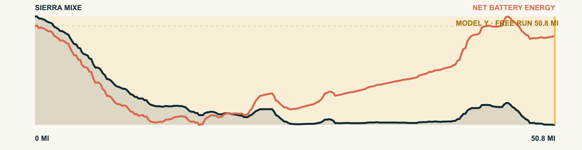
For the 2026 Model Y Premium AWD, the model shows that the battery stays at or above its starting charge for 50.8 of 50.8 road miles. The highest energy surplus is 6.5 kWh. This equals about 23.6 miles at the EPA energy rate. The result shows how the road grade and speed can reduce net energy use.
- Battery-hold miles
- 50.8
- Route length
- 50.8 mi
- Share of route
- 100%
- Total descent
- 10,660 ft
- Peak surplus
- 6.5 kWh
- EPA-eq. banked
- 23.6 mi
#18 / COLORADO, USA
Mount Blue Sky
Mount Blue Sky Scenic Byway → Denver Foothills
WHAT THIS ROAD SHOWS
The highest paved road in North America leaves alpine tundra, passes Echo Lake, and follows Front Range canyons to the edge of the Denver basin.
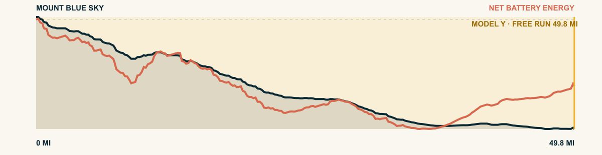
For the 2026 Model Y Premium AWD, the model shows that the battery stays at or above its starting charge for 49.8 of 49.8 road miles. The highest energy surplus is 4.5 kWh. This equals about 16.4 miles at the EPA energy rate. The result shows how the road grade and speed can reduce net energy use.
- Battery-hold miles
- 49.8
- Route length
- 49.8 mi
- Share of route
- 100%
- Total descent
- 9,233 ft
- Peak surplus
- 4.5 kWh
- EPA-eq. banked
- 16.4 mi

#19 / COLORADO, USA
Trail Ridge
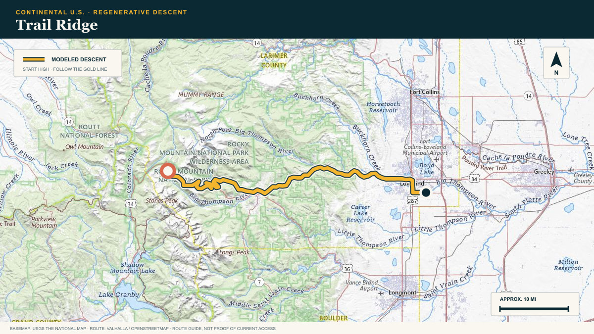
Trail Ridge Road (US-34), Rocky Mountain National Park
WHAT THIS ROAD SHOWS
America’s rooftop drive. From the alpine tundra above Estes Park the road gives back every foot of its famous climb, 8,700 cumulative feet of descent to the plains apron.
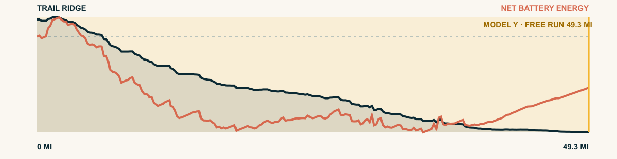
For the 2026 Model Y Premium AWD, the model shows that the battery stays at or above its starting charge for 49.3 of 49.3 road miles. The highest energy surplus is 2.8 kWh. This equals about 10.3 miles at the EPA energy rate. The result shows how the road grade and speed can reduce net energy use.
- Battery-hold miles
- 49.3
- Route length
- 49.3 mi
- Share of route
- 100%
- Total descent
- 7,919 ft
- Peak surplus
- 2.8 kWh
- EPA-eq. banked
- 10.3 mi
#20 / UTAH, USA
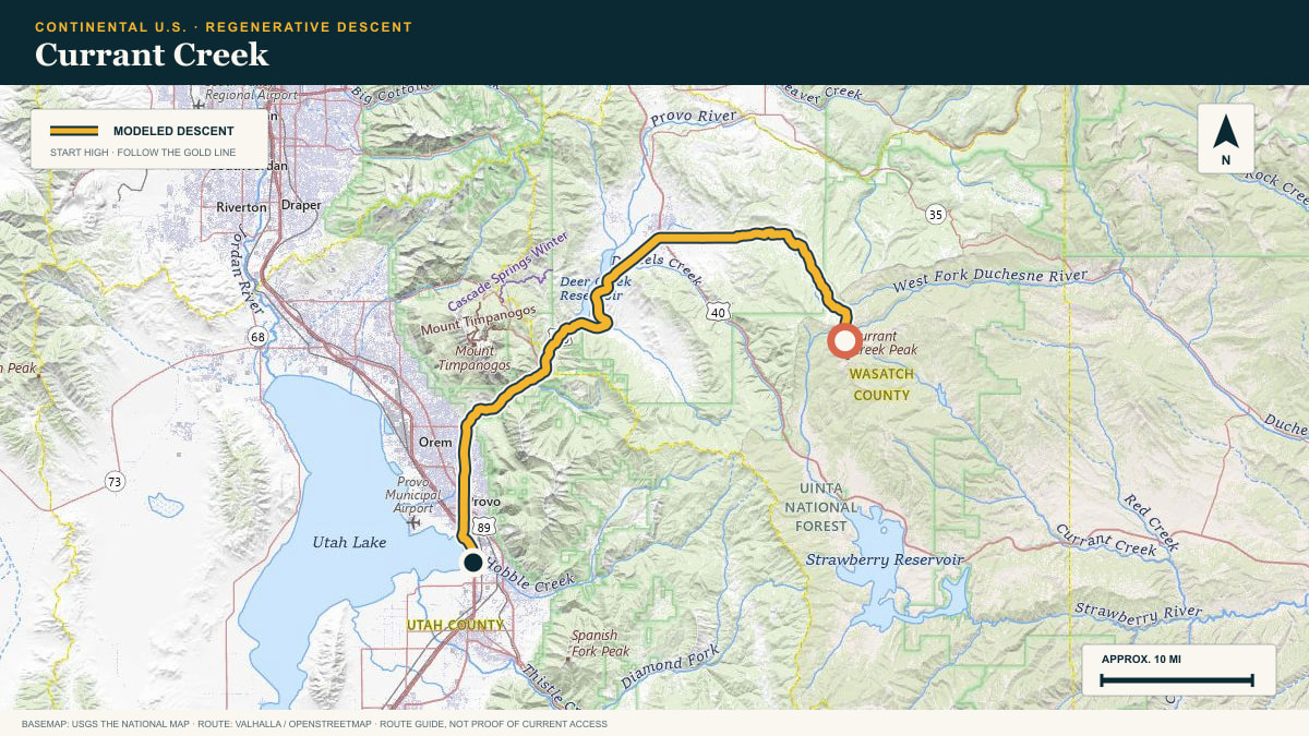
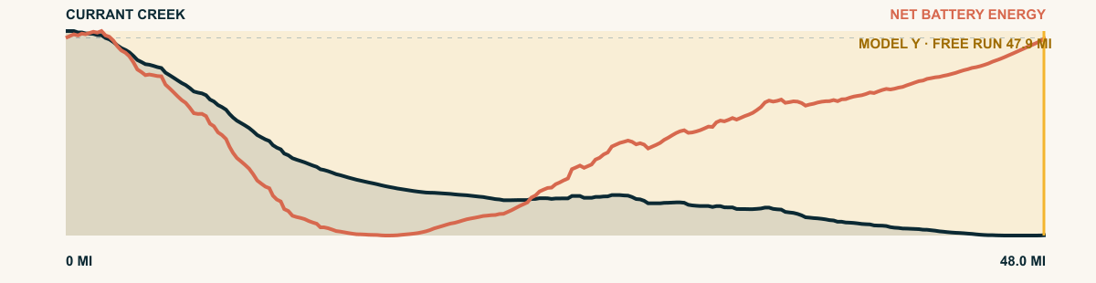
Currant Creek
Lake Creek–Currant Creek Road → Utah Valley
WHAT THIS ROAD SHOWS
The run begins on a quiet forest road east of the Wasatch crest, then links into the broad descent toward Utah Valley. It is less theatrical than a summit byway and longer for exactly that reason.
For the 2026 Model Y Premium AWD, the model shows that the battery stays at or above its starting charge for 47.9 of 48 road miles. The highest energy surplus is 3 kWh. This equals about 11.1 miles at the EPA energy rate. The result shows how the road grade and speed can reduce net energy use.
- Battery-hold miles
- 47.9
- Route length
- 48 mi
- Share of route
- 100%
- Total descent
- 5,737 ft
- Peak surplus
- 3 kWh
- EPA-eq. banked
- 11.1 mi
#21 / CHIAPAS, MEXICO
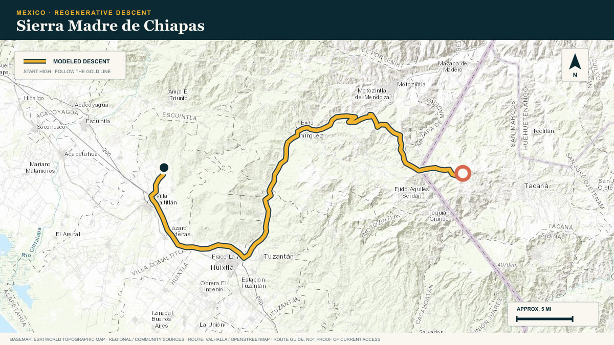
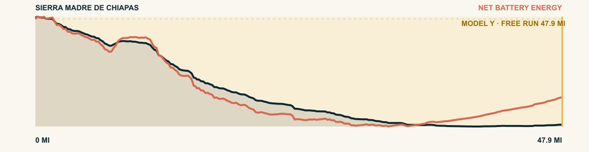
Sierra Madre de Chiapas
Niquivil → Huixtla, MEX-211 corridor
WHAT THIS ROAD SHOWS
The route leaves the Sierra Madre de Chiapas near Niquivil. It descends to the banana and cacao farms of the Soconusco plain near the Pacific.
For the 2026 Model Y Premium AWD, the model shows that the battery stays at or above its starting charge for 47.9 of 47.9 road miles. The highest energy surplus is 7.9 kWh. This equals about 28.9 miles at the EPA energy rate. The result shows how the road grade and speed can reduce net energy use.
- Battery-hold miles
- 47.9
- Route length
- 47.9 mi
- Share of route
- 100%
- Total descent
- 11,002 ft
- Peak surplus
- 7.9 kWh
- EPA-eq. banked
- 28.9 mi
#22 / OREGON, USA
Steens Mountain
Steens Mountain Loop Road
WHAT THIS ROAD SHOWS
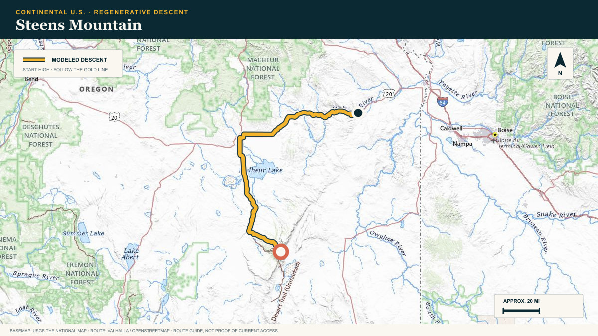
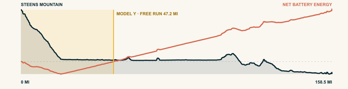
A fault-block mountain that tilts out of the Great Basin like a breaking wave. The descent starts at the gorge-cut crest and runs long and lonely through the high desert.
For the 2026 Model Y Premium AWD, the model shows that the battery stays at or above its starting charge for 47.2 of 158.5 road miles. The highest energy surplus is 3.8 kWh. This equals about 13.9 miles at the EPA energy rate. The result shows how the road grade and speed can reduce net energy use.
- Battery-hold miles
- 47.2
- Route length
- 158.5 mi
- Share of route
- 30%
- Total descent
- 10,077 ft
- Peak surplus
- 3.8 kWh
- EPA-eq. banked
- 13.9 mi
#23 / ARIZONA, USA
Mount Lemmon
Catalina Highway → Tucson basin
WHAT THIS ROAD SHOWS
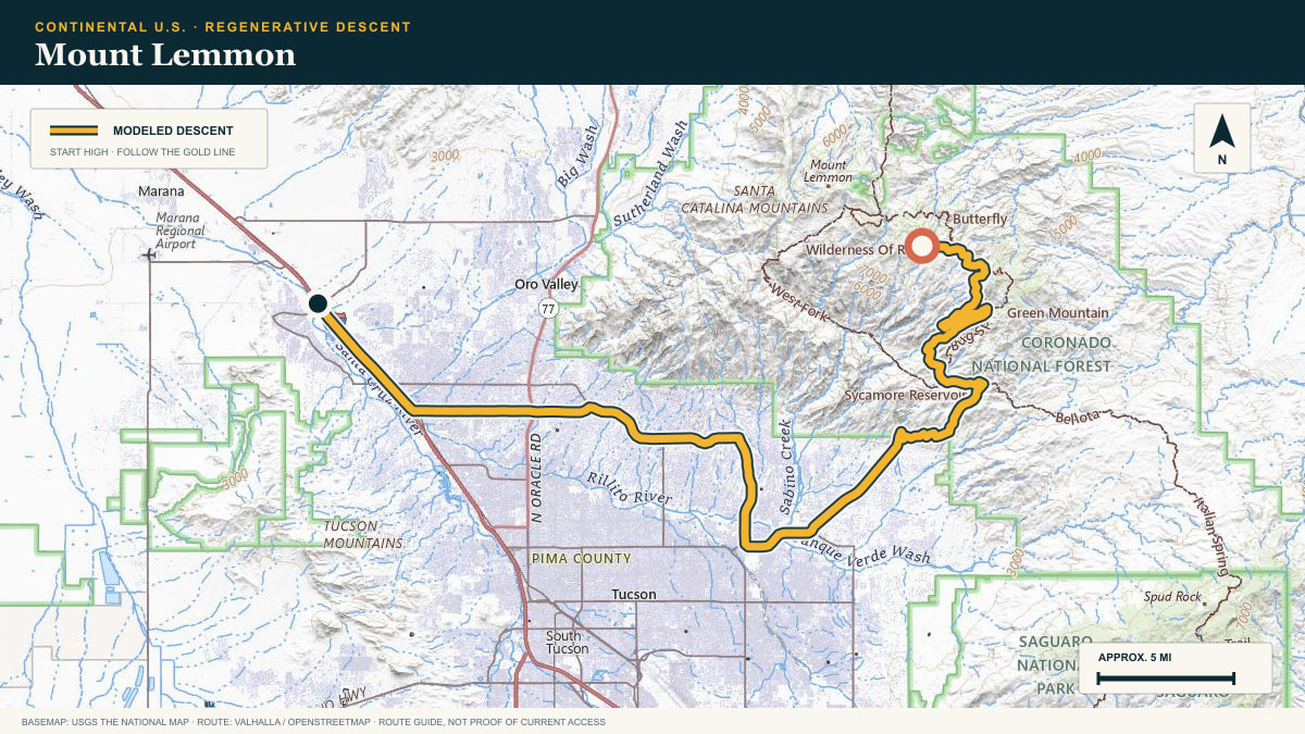
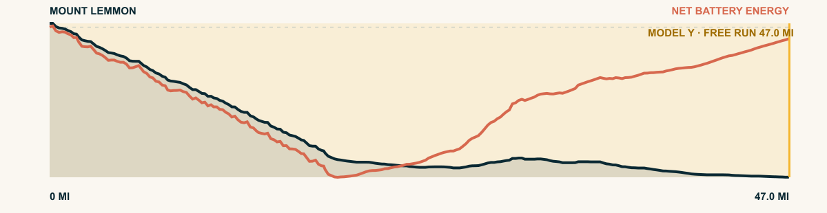
Pines, granite hoodoos, saguaros: the descent changes worlds in a single run. Below the tight mountain curves, Tucson’s gridded basin becomes the destination and the scale of the drop becomes obvious.
For the 2026 Model Y Premium AWD, the model shows that the battery stays at or above its starting charge for 47 of 47 road miles. The highest energy surplus is 4 kWh. This equals about 14.7 miles at the EPA energy rate. The result shows how the road grade and speed can reduce net energy use.
- Battery-hold miles
- 47
- Route length
- 47 mi
- Share of route
- 100%
- Total descent
- 6,506 ft
- Peak surplus
- 4 kWh
- EPA-eq. banked
- 14.7 mi
#24 / CALIFORNIA, USA
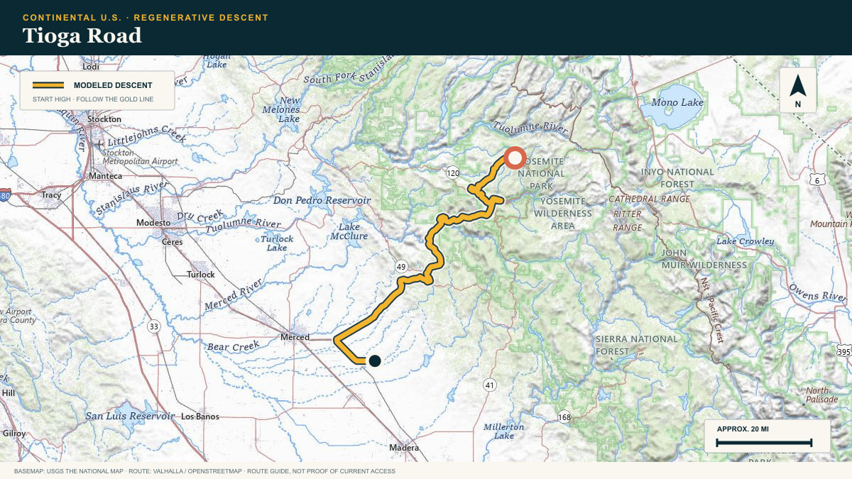
Tioga Road
Tioga Road (CA-120) west out of the Yosemite high country
WHAT THIS ROAD SHOWS
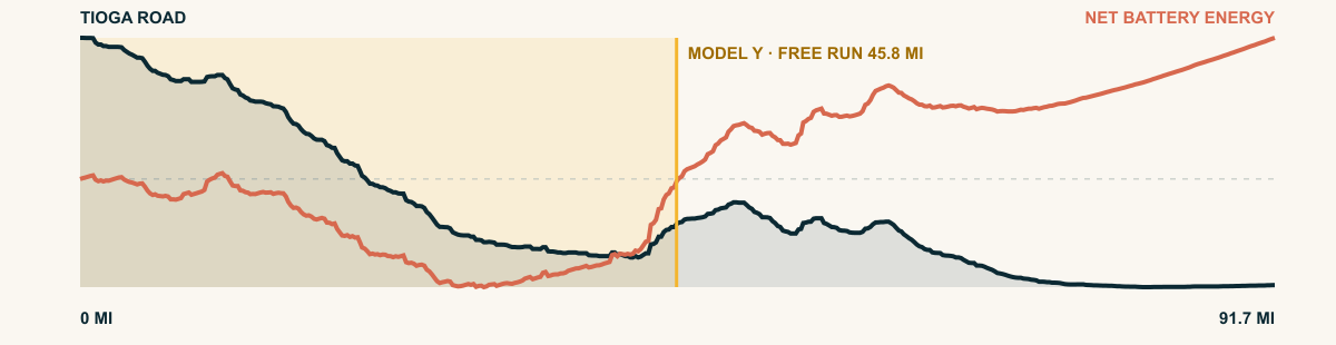
Yosemite’s high road. From the subalpine meadows near the crest the pavement sinks 12,800 cumulative feet through the granite backcountry toward the San Joaquin lowlands.
For the 2026 Model Y Premium AWD, the model shows that the battery stays at or above its starting charge for 45.8 of 91.7 road miles. The highest energy surplus is 3.7 kWh. This equals about 13.6 miles at the EPA energy rate. The result shows how the road grade and speed can reduce net energy use.
- Battery-hold miles
- 45.8
- Route length
- 91.7 mi
- Share of route
- 50%
- Total descent
- 11,173 ft
- Peak surplus
- 3.7 kWh
- EPA-eq. banked
- 13.6 mi
#25 / OAXACA, MEXICO
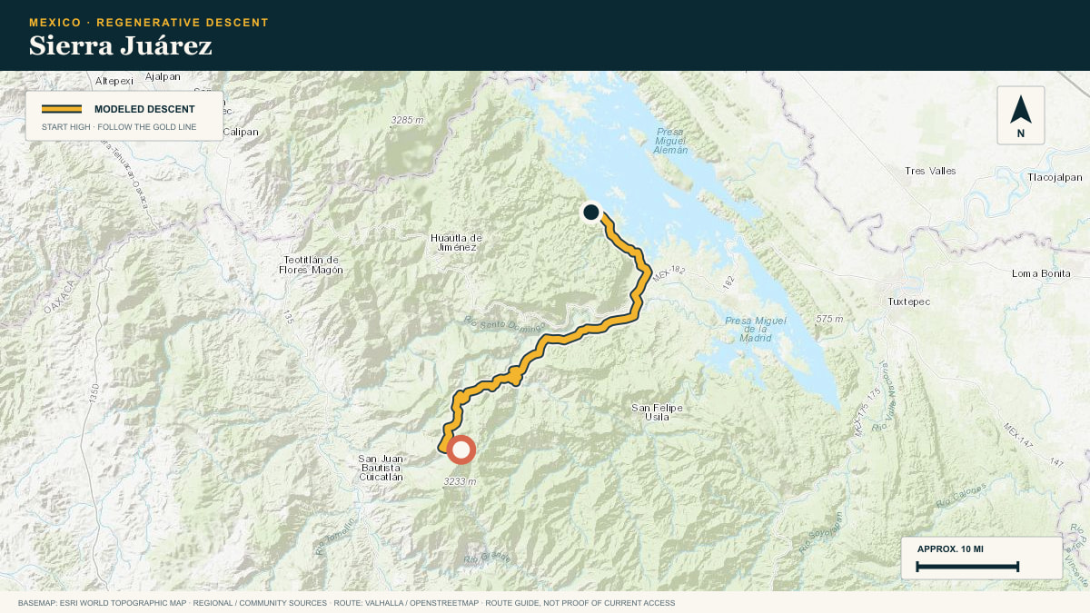
Sierra Juárez
the Ixtlán highlands toward the Papaloapan lowlands
WHAT THIS ROAD SHOWS
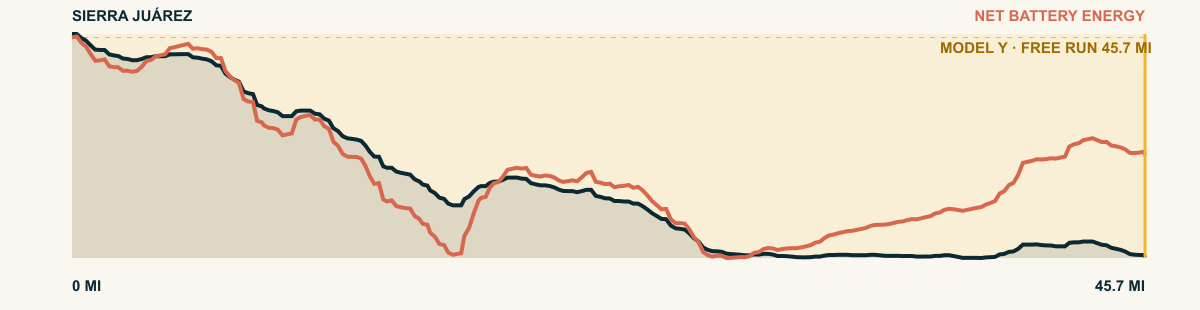
The green wall between Oaxaca’s dry central valleys and the steaming Papaloapan basin. The road drops through cloud forest that wrings water from Gulf air, shedding 15,700 cumulative feet.
For the 2026 Model Y Premium AWD, the model shows that the battery stays at or above its starting charge for 45.7 of 45.7 road miles. The highest energy surplus is 6.3 kWh. This equals about 23 miles at the EPA energy rate. The result shows how the road grade and speed can reduce net energy use.
- Battery-hold miles
- 45.7
- Route length
- 45.7 mi
- Share of route
- 100%
- Total descent
- 11,726 ft
- Peak surplus
- 6.3 kWh
- EPA-eq. banked
- 23 mi
#26 / MAUI, HAWAIʻI
Haleakalā
Haleakalā Highway · Crater Road
WHAT THIS ROAD SHOWS
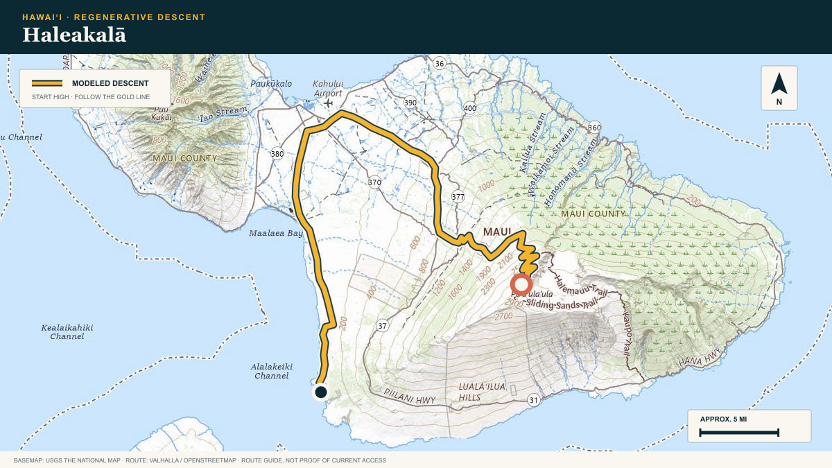
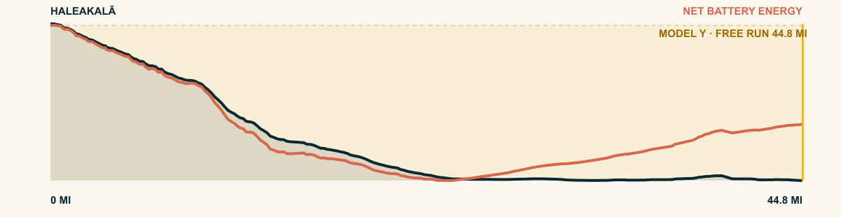
From the national-park road on Haleakalā’s flank, the pavement descends in one sustained sweep from volcanic summit country to the warm Kīhei shore.
For the 2026 Model Y Premium AWD, the model shows that the battery stays at or above its starting charge for 44.8 of 44.8 road miles. The highest energy surplus is 8.3 kWh. This equals about 30.3 miles at the EPA energy rate. The result shows how the road grade and speed can reduce net energy use.
- Battery-hold miles
- 44.8
- Route length
- 44.8 mi
- Share of route
- 100%
- Total descent
- 9,682 ft
- Peak surplus
- 8.3 kWh
- EPA-eq. banked
- 30.3 mi
#27 / COLORADO, USA
Deadman Hill
Deadman Road toward the Laramie River valley
WHAT THIS ROAD SHOWS
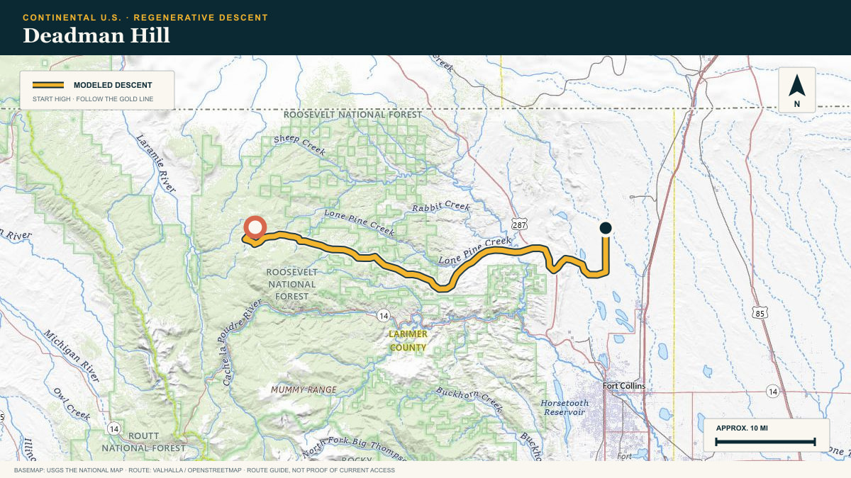
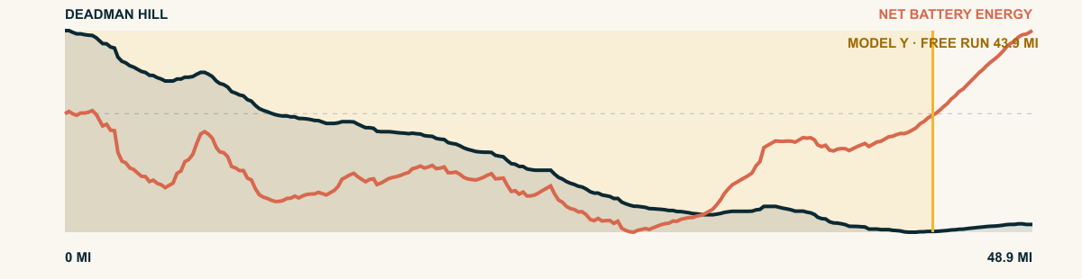
No park, no byway sign — just lodgepole country north of Cameron Pass. Off Deadman Hill the road falls to the Laramie River’s hay meadows, 6,400 cumulative feet down.
For the 2026 Model Y Premium AWD, the model shows that the battery stays at or above its starting charge for 43.9 of 48.9 road miles. The highest energy surplus is 1.5 kWh. This equals about 5.4 miles at the EPA energy rate. The result shows how the road grade and speed can reduce net energy use.
- Battery-hold miles
- 43.9
- Route length
- 48.9 mi
- Share of route
- 90%
- Total descent
- 5,674 ft
- Peak surplus
- 1.5 kWh
- EPA-eq. banked
- 5.4 mi
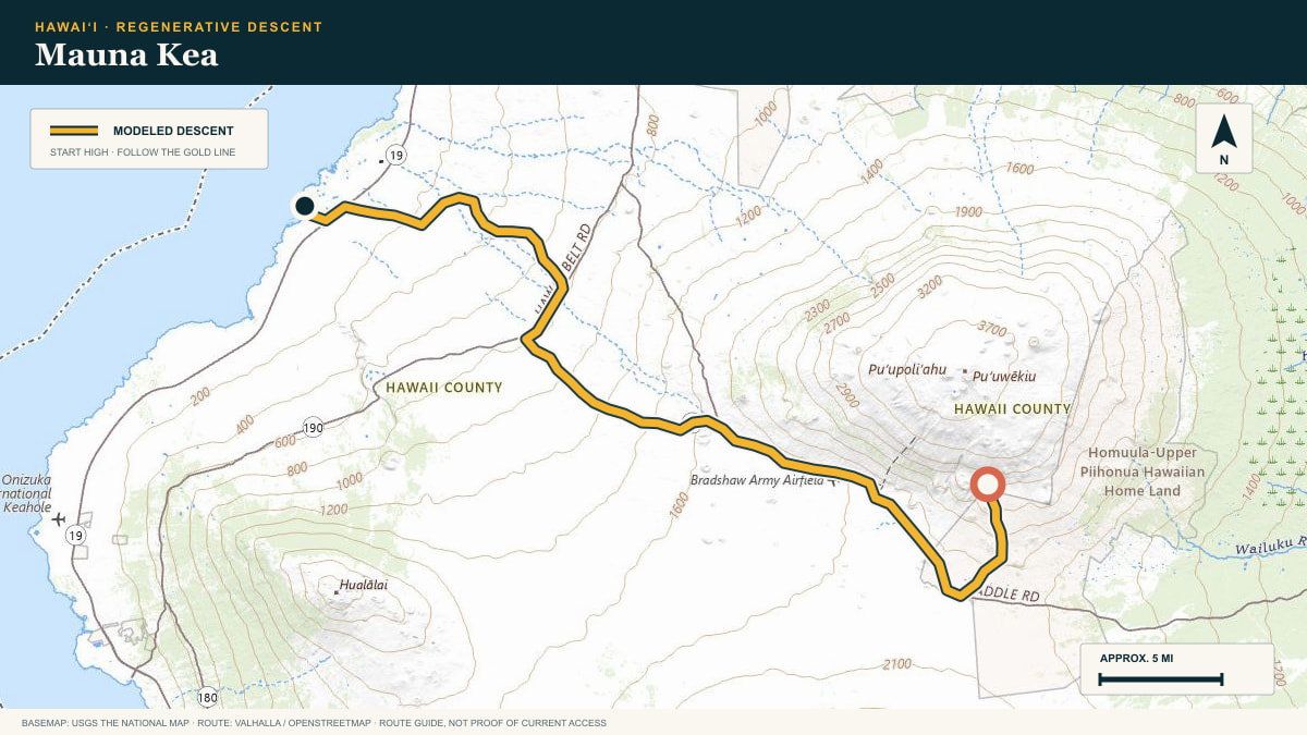
#28 / ISLAND OF HAWAIʻI
Mauna Kea
Mauna Kea Access Road · Daniel K. Inouye Highway
WHAT THIS ROAD SHOWS
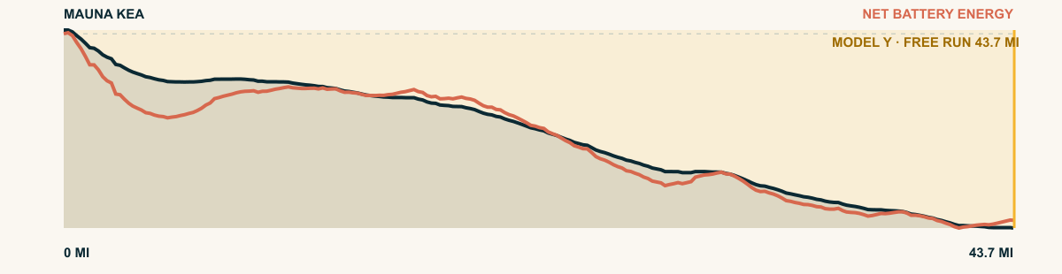
The access road drops from the visitor station to the saddle between Mauna Kea and Mauna Loa. It then crosses lava country toward Waikoloa.
For the 2026 Model Y Premium AWD, the model shows that the battery stays at or above its starting charge for 43.7 of 43.7 road miles. The highest energy surplus is 5.2 kWh. This equals about 19.1 miles at the EPA energy rate. The result shows how the road grade and speed can reduce net energy use.
- Battery-hold miles
- 43.7
- Route length
- 43.7 mi
- Share of route
- 100%
- Total descent
- 9,102 ft
- Peak surplus
- 5.2 kWh
- EPA-eq. banked
- 19.1 mi
#29 / NEVADA, USA
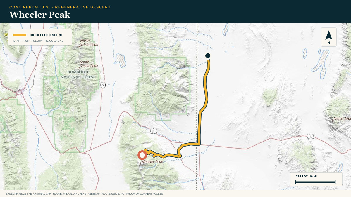
Wheeler Peak
Wheeler Peak Scenic Drive — Great Basin National Park
WHAT THIS ROAD SHOWS
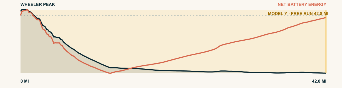
The road leaves the Snake Range above 10,000 feet. It descends across the basin floor. The last dry miles are long and straight.
For the 2026 Model Y Premium AWD, the model shows that the battery stays at or above its starting charge for 42.8 of 42.8 road miles. The highest energy surplus is 3.9 kWh. This equals about 14.3 miles at the EPA energy rate. The result shows how the road grade and speed can reduce net energy use.
- Battery-hold miles
- 42.8
- Route length
- 42.8 mi
- Share of route
- 100%
- Total descent
- 5,270 ft
- Peak surplus
- 3.9 kWh
- EPA-eq. banked
- 14.3 mi
#30 / NUEVO LEÓN, MEXICO
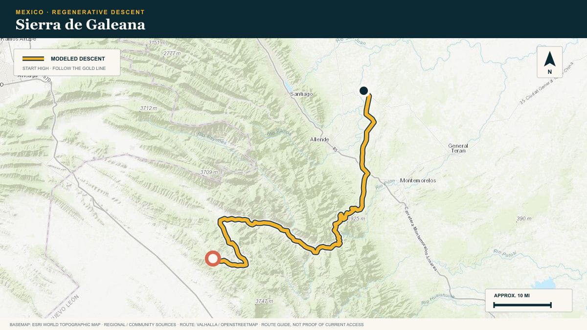
Sierra de Galeana
off the Galeana high valley toward Linares
WHAT THIS ROAD SHOWS
The Sierra Madre Oriental stacks range on range here. From Galeana’s cool apple-orchard valley the road steps down the front of the sierra toward the citrus plain of Linares.
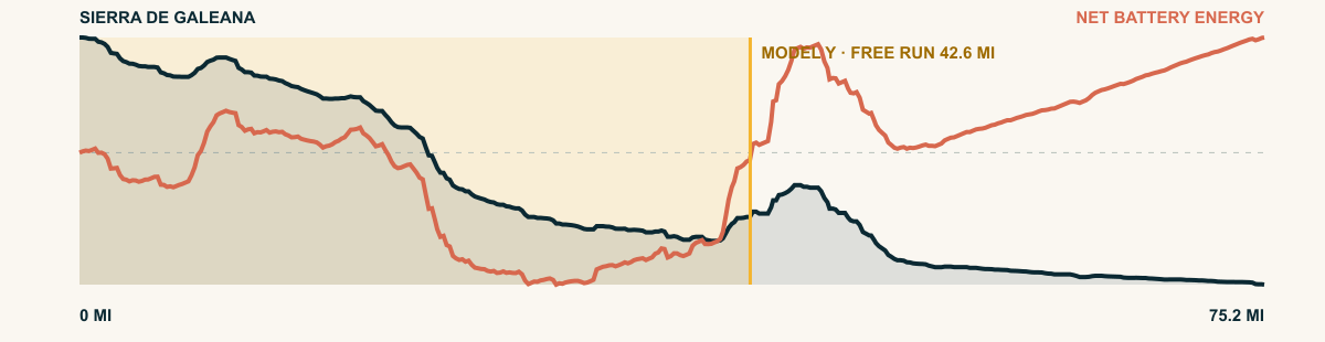
For the 2026 Model Y Premium AWD, the model shows that the battery stays at or above its starting charge for 42.6 of 75.2 road miles. The highest energy surplus is 2.8 kWh. This equals about 10.1 miles at the EPA energy rate. The result shows how the road grade and speed can reduce net energy use.
- Battery-hold miles
- 42.6
- Route length
- 75.2 mi
- Share of route
- 57%
- Total descent
- 10,682 ft
- Peak surplus
- 2.8 kWh
- EPA-eq. banked
- 10.1 mi
#31 / IDAHO, USA
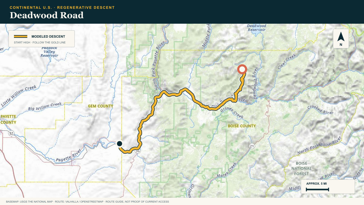
Deadwood Road
Deadwood Road → Payette River country
WHAT THIS ROAD SHOWS
This descent feels earned: a remote forest road rolls across the divide, then commits west through tighter drainages. The route finally opens toward the farms and dry foothills above the Payette.
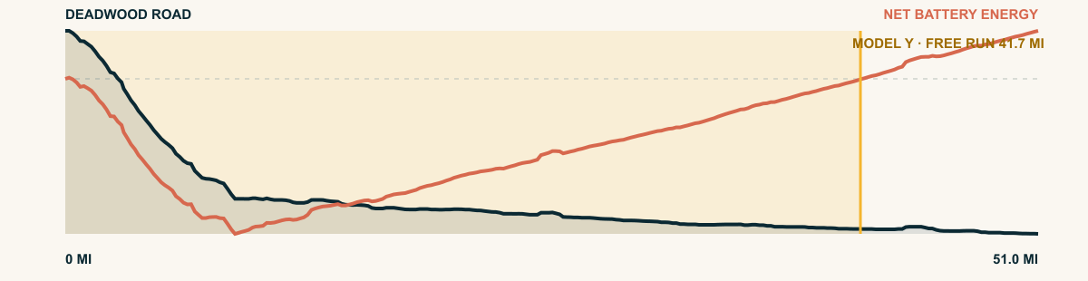
For the 2026 Model Y Premium AWD, the model shows that the battery stays at or above its starting charge for 41.7 of 51 road miles. The highest energy surplus is 3.9 kWh. This equals about 14.3 miles at the EPA energy rate. The result shows how the road grade and speed can reduce net energy use.
- Battery-hold miles
- 41.7
- Route length
- 51 mi
- Share of route
- 82%
- Total descent
- 5,269 ft
- Peak surplus
- 3.9 kWh
- EPA-eq. banked
- 14.3 mi
#32 / UTAH, USA
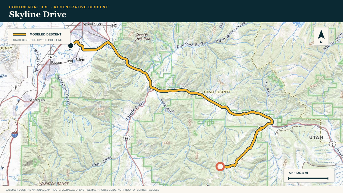
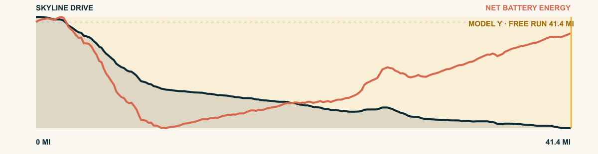
Skyline Drive
Skyline Drive → Utah Valley
WHAT THIS ROAD SHOWS
The route leaves a high, exposed ridge and descends northwest through aspen and canyon country. The last leg reaches the Wasatch Front with the mountain’s energy credit still doing work.
For the 2026 Model Y Premium AWD, the model shows that the battery stays at or above its starting charge for 41.4 of 41.4 road miles. The highest energy surplus is 2.6 kWh. This equals about 9.5 miles at the EPA energy rate. The result shows how the road grade and speed can reduce net energy use.
- Battery-hold miles
- 41.4
- Route length
- 41.4 mi
- Share of route
- 100%
- Total descent
- 5,027 ft
- Peak surplus
- 2.6 kWh
- EPA-eq. banked
- 9.5 mi
#33 / GUERRERO, MEXICO
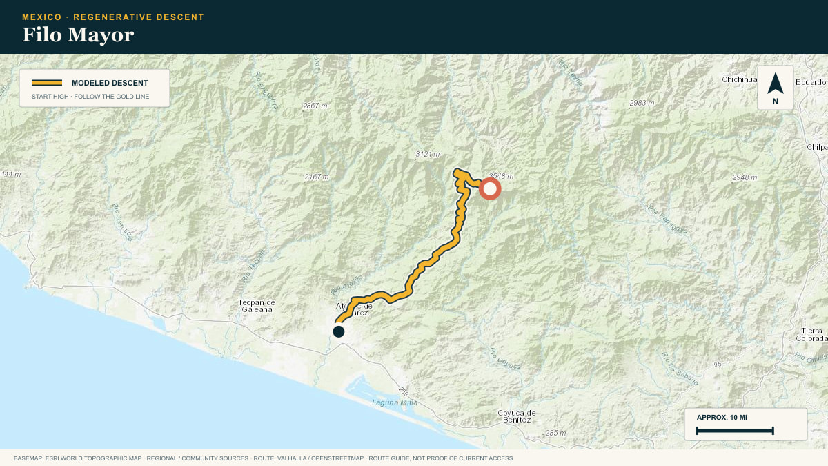
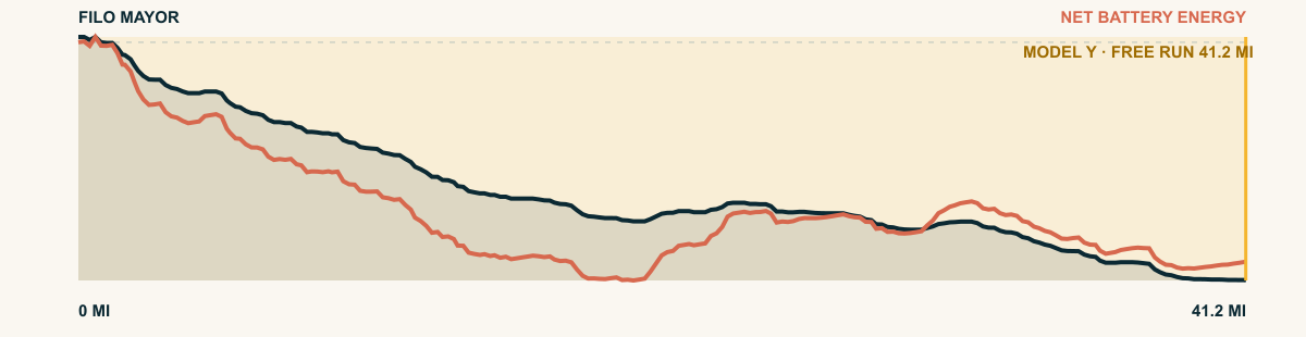
Filo Mayor
Sierra Madre del Sur · toward Atoyac
WHAT THIS ROAD SHOWS
The road leaves the cold Filo Mayor ridge and descends the Sierra Madre del Sur. It passes through coffee country and reaches the coastal plain northwest of Acapulco.
For the 2026 Model Y Premium AWD, the model shows that the battery stays at or above its starting charge for 41.2 of 41.2 road miles. The highest energy surplus is 7.3 kWh. This equals about 26.6 miles at the EPA energy rate. The result shows how the road grade and speed can reduce net energy use.
- Battery-hold miles
- 41.2
- Route length
- 41.2 mi
- Share of route
- 100%
- Total descent
- 12,070 ft
- Peak surplus
- 7.3 kWh
- EPA-eq. banked
- 26.6 mi
#34 / CALIFORNIA, USA
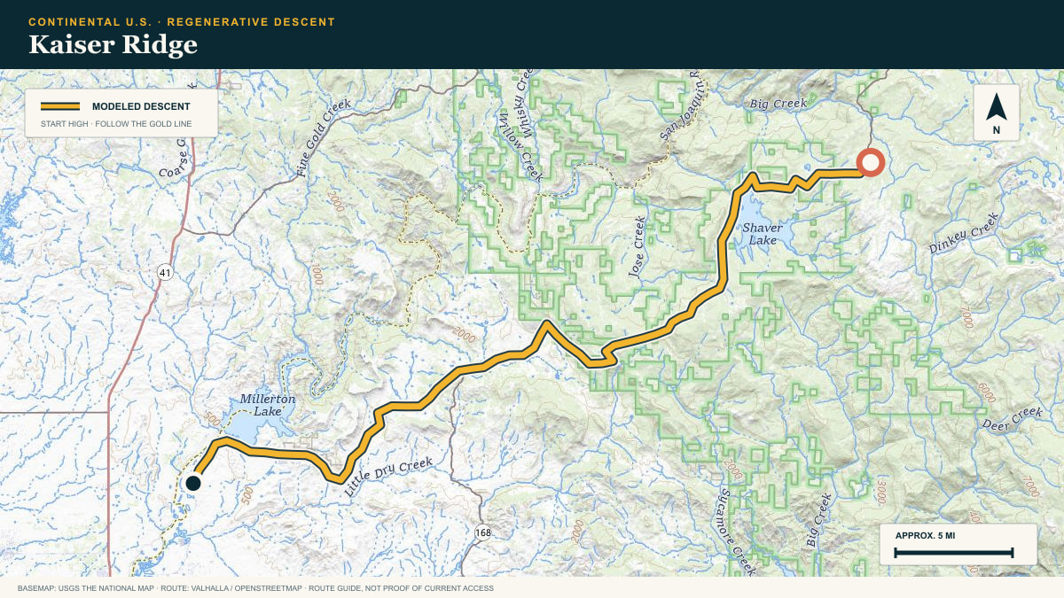
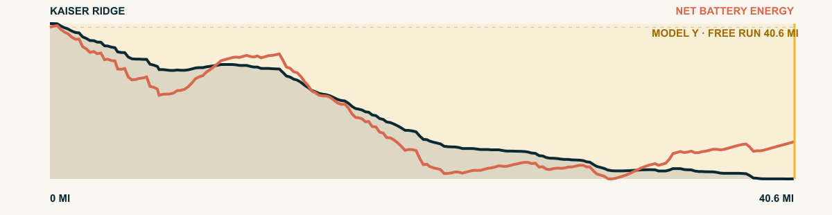
Kaiser Ridge
CA-168 off Huntington Lake
WHAT THIS ROAD SHOWS
The western Sierra falls away in one continuous shelf here. From Huntington Lake the highway drops 8,700 cumulative feet to the foothill oaks above Fresno.
For the 2026 Model Y Premium AWD, the model shows that the battery stays at or above its starting charge for 40.6 of 40.6 road miles. The highest energy surplus is 4.1 kWh. This equals about 15.1 miles at the EPA energy rate. The result shows how the road grade and speed can reduce net energy use.
- Battery-hold miles
- 40.6
- Route length
- 40.6 mi
- Share of route
- 100%
- Total descent
- 7,663 ft
- Peak surplus
- 4.1 kWh
- EPA-eq. banked
- 15.1 mi
#35 / NEW MEXICO, USA
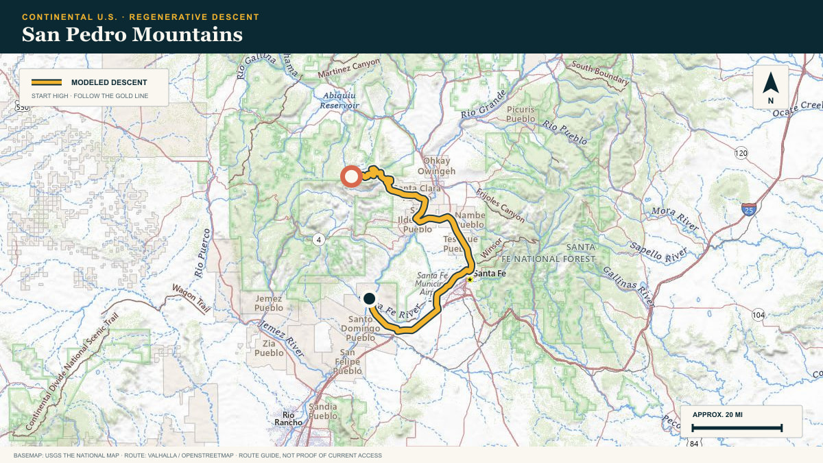
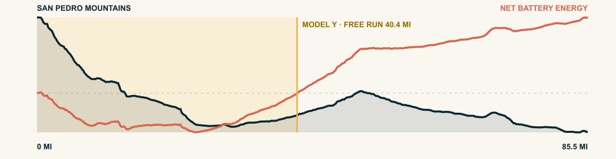
San Pedro Mountains
31 Mile Road off the Jemez highlands
WHAT THIS ROAD SHOWS
North of the Valles Caldera the Jemez country rolls at 10,000 ft in meadowed domes. The road works down through ponderosa benches toward the red Chama basin.
For the 2026 Model Y Premium AWD, the model shows that the battery stays at or above its starting charge for 40.4 of 85.5 road miles. The highest energy surplus is 3.2 kWh. This equals about 11.7 miles at the EPA energy rate. The result shows how the road grade and speed can reduce net energy use.
- Battery-hold miles
- 40.4
- Route length
- 85.5 mi
- Share of route
- 47%
- Total descent
- 7,953 ft
- Peak surplus
- 3.2 kWh
- EPA-eq. banked
- 11.7 mi
#36 / MICHOACÁN, MEXICO
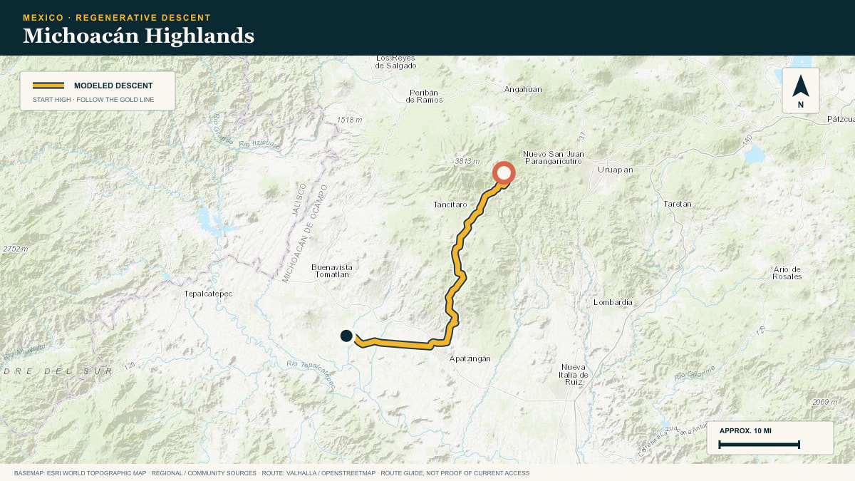
Michoacán Highlands
Paricutín country → Tepalcatepec Valley
WHAT THIS ROAD SHOWS
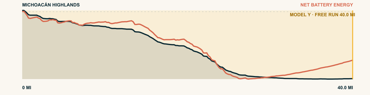
From the cool avocado highlands west of Uruapan, the road falls off the edge of the volcanic plateau into the heat of the Tierra Caliente.
For the 2026 Model Y Premium AWD, the model shows that the battery stays at or above its starting charge for 40 of 40 road miles. The highest energy surplus is 5.2 kWh. This equals about 19.1 miles at the EPA energy rate. The result shows how the road grade and speed can reduce net energy use.
- Battery-hold miles
- 40
- Route length
- 40 mi
- Share of route
- 100%
- Total descent
- 7,644 ft
- Peak surplus
- 5.2 kWh
- EPA-eq. banked
- 19.1 mi
#37 / CALIFORNIA, USA
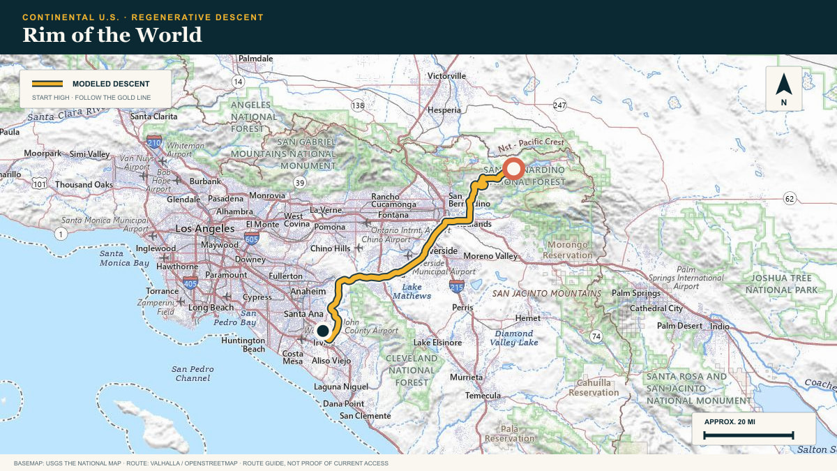
Rim of the World
Rim of the World Highway → Orange County
WHAT THIS ROAD SHOWS
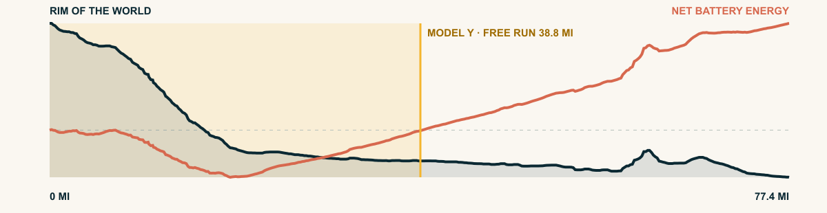
The highway leaves the mountain rim in long, exposed curves, trades conifers for chaparral, and then continues across the inland plain. The free run survives well beyond the obvious mountain grade.
For the 2026 Model Y Premium AWD, the model shows that the battery stays at or above its starting charge for 38.8 of 77.4 road miles. The highest energy surplus is 3.3 kWh. This equals about 12.2 miles at the EPA energy rate. The result shows how the road grade and speed can reduce net energy use.
- Battery-hold miles
- 38.8
- Route length
- 77.4 mi
- Share of route
- 50%
- Total descent
- 8,500 ft
- Peak surplus
- 3.3 kWh
- EPA-eq. banked
- 12.2 mi
#38 / PINALEÑO MOUNTAINS, ARIZONA, USA
Mount Graham
Swift Trail · State Route 366
WHAT THIS ROAD SHOWS
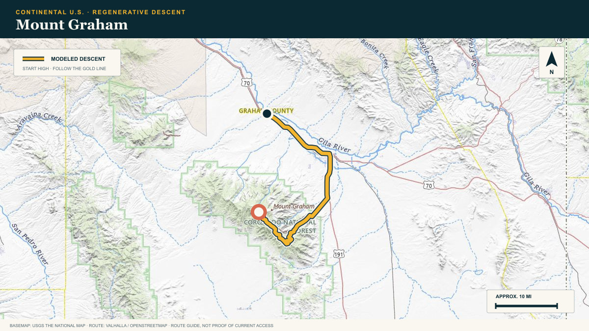
The Pinaleños rise abruptly from the Gila Valley. The Swift Trail reverses that climb through switchbacks and sky-island forest before reaching the cotton fields near Safford.
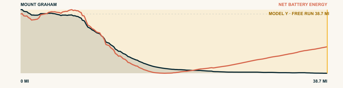
For the 2026 Model Y Premium AWD, the model shows that the battery stays at or above its starting charge for 38.7 of 38.7 road miles. The highest energy surplus is 5.1 kWh. This equals about 18.4 miles at the EPA energy rate. The result shows how the road grade and speed can reduce net energy use.
- Battery-hold miles
- 38.7
- Route length
- 38.7 mi
- Share of route
- 100%
- Total descent
- 6,954 ft
- Peak surplus
- 5.1 kWh
- EPA-eq. banked
- 18.4 mi
#39 / NEW MEXICO, USA
Sandia Crest
Sandia Crest Scenic Byway → Albuquerque
WHAT THIS ROAD SHOWS
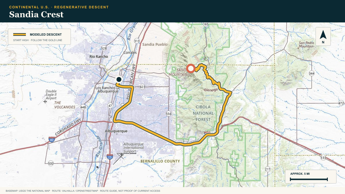
The road leaves spruce and fir near the crest, loops around the mountain’s east shoulder, then pays out its elevation toward the Rio Grande. Albuquerque spreads across the basin long before the descent is finished.
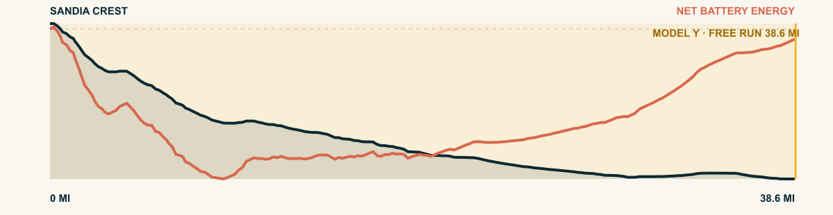
For the 2026 Model Y Premium AWD, the model shows that the battery stays at or above its starting charge for 38.6 of 38.6 road miles. The highest energy surplus is 2.8 kWh. This equals about 10.2 miles at the EPA energy rate. The result shows how the road grade and speed can reduce net energy use.
- Battery-hold miles
- 38.6
- Route length
- 38.6 mi
- Share of route
- 100%
- Total descent
- 5,526 ft
- Peak surplus
- 2.8 kWh
- EPA-eq. banked
- 10.2 mi
#40 / NEW MEXICO, USA
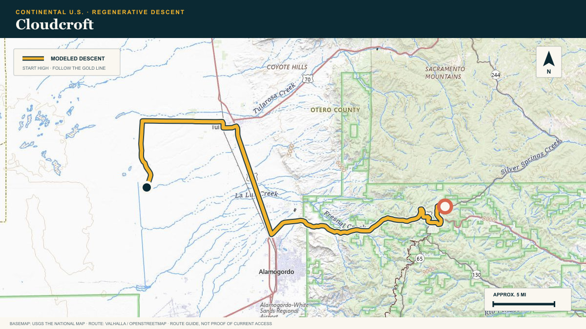
Cloudcroft
NM-244 · Cloudcroft → Tularosa Basin
WHAT THIS ROAD SHOWS
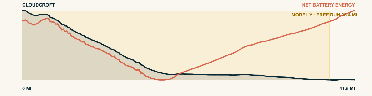
The road leaves cool fir forest and drops toward a desert bright enough to fill the windshield. Few routes make the boundary between mountain and basin feel this abrupt.
For the 2026 Model Y Premium AWD, the model shows that the battery stays at or above its starting charge for 38.4 of 41.5 road miles. The highest energy surplus is 2.8 kWh. This equals about 10.1 miles at the EPA energy rate. The result shows how the road grade and speed can reduce net energy use.
- Battery-hold miles
- 38.4
- Route length
- 41.5 mi
- Share of route
- 93%
- Total descent
- 4,958 ft
- Peak surplus
- 2.8 kWh
- EPA-eq. banked
- 10.1 mi
#41 / UTAH, USA
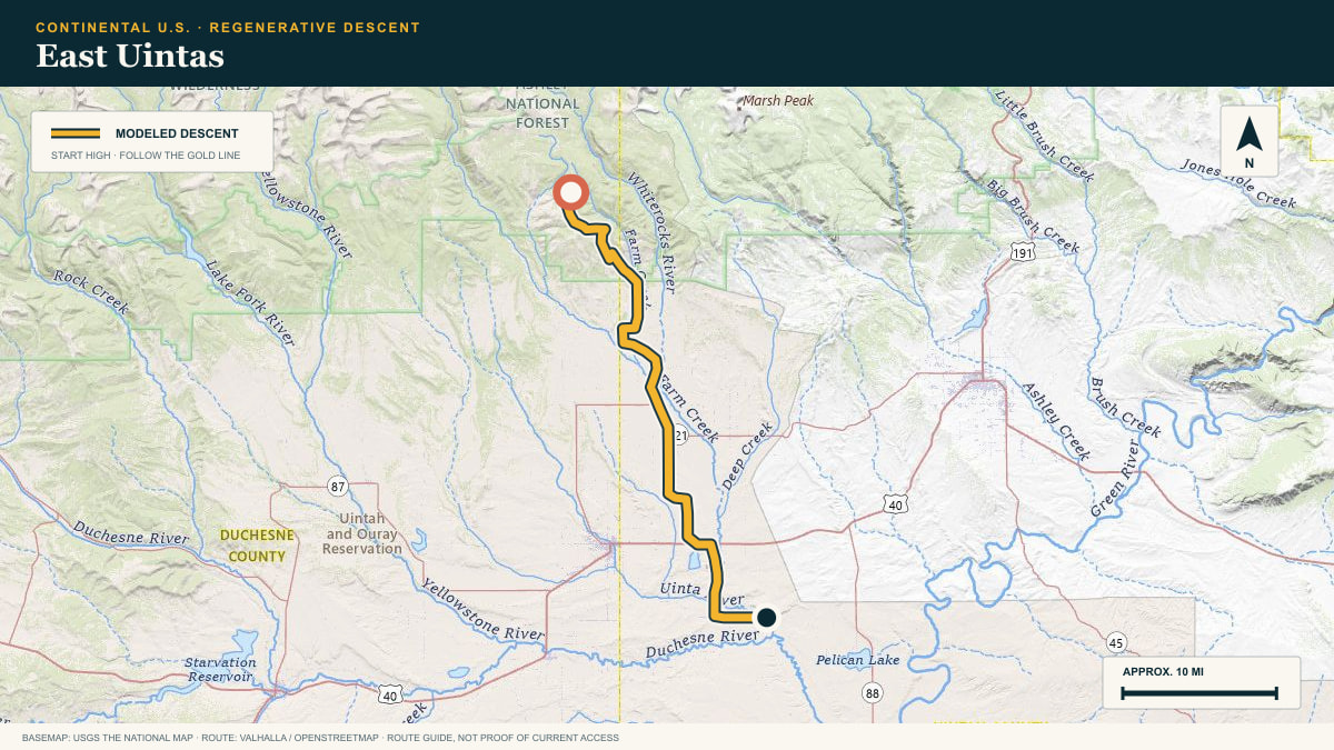
East Uintas
US-191 · Flaming Gorge–Vernal
WHAT THIS ROAD SHOWS
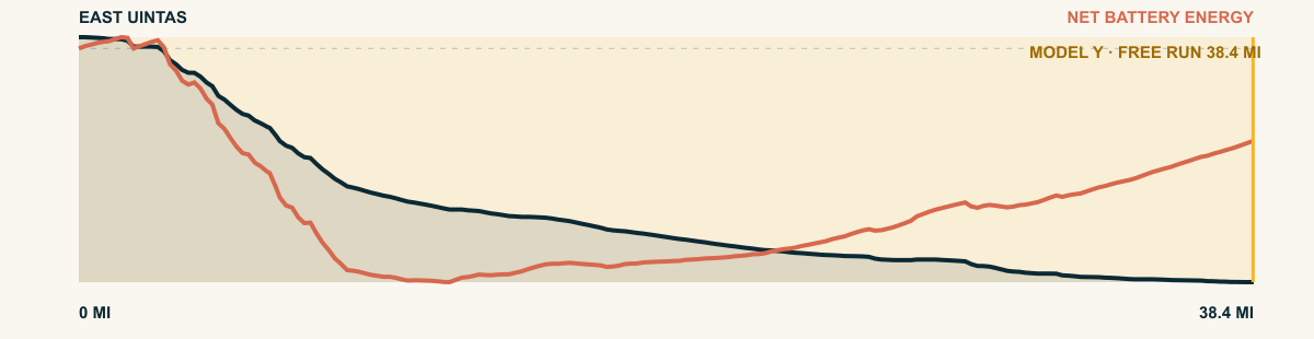
US-191 crests the eastern Uintas and then unwinds through tilted red rock to the Ashley Valley floor at Vernal—a quiet road with a remarkably steady grade.
For the 2026 Model Y Premium AWD, the model shows that the battery stays at or above its starting charge for 38.4 of 38.4 road miles. The highest energy surplus is 2.9 kWh. This equals about 10.6 miles at the EPA energy rate. The result shows how the road grade and speed can reduce net energy use.
- Battery-hold miles
- 38.4
- Route length
- 38.4 mi
- Share of route
- 100%
- Total descent
- 5,210 ft
- Peak surplus
- 2.9 kWh
- EPA-eq. banked
- 10.6 mi
#42 / JALISCO, MEXICO
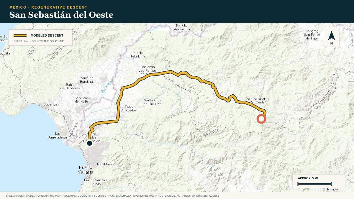
San Sebastián del Oeste
La Bufa grade → Puerto Vallarta
WHAT THIS ROAD SHOWS
The highway leaves cloud forest above San Sebastián del Oeste. It descends toward Banderas Bay and the warm air of Puerto Vallarta.
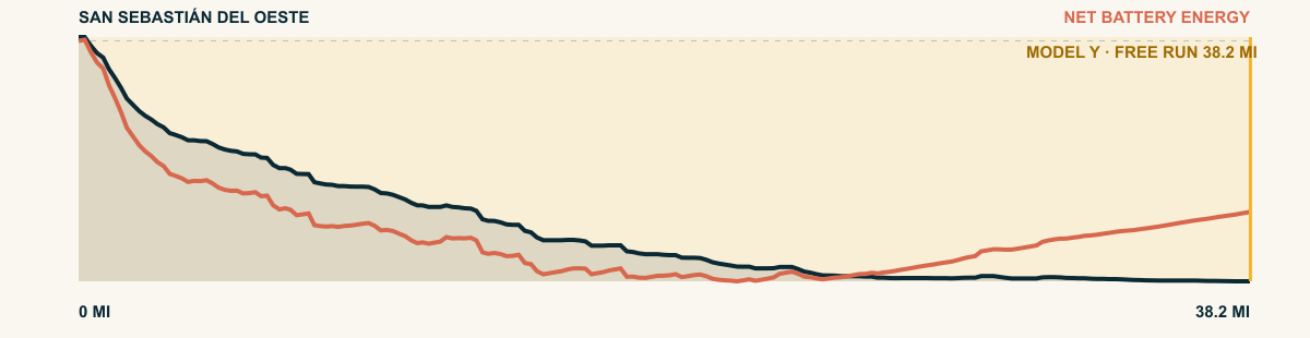
For the 2026 Model Y Premium AWD, the model shows that the battery stays at or above its starting charge for 38.2 of 38.2 road miles. The highest energy surplus is 6.4 kWh. This equals about 23.3 miles at the EPA energy rate. The result shows how the road grade and speed can reduce net energy use.
- Battery-hold miles
- 38.2
- Route length
- 38.2 mi
- Share of route
- 100%
- Total descent
- 8,179 ft
- Peak surplus
- 6.4 kWh
- EPA-eq. banked
- 23.3 mi
#43 / ARIZONA, USA
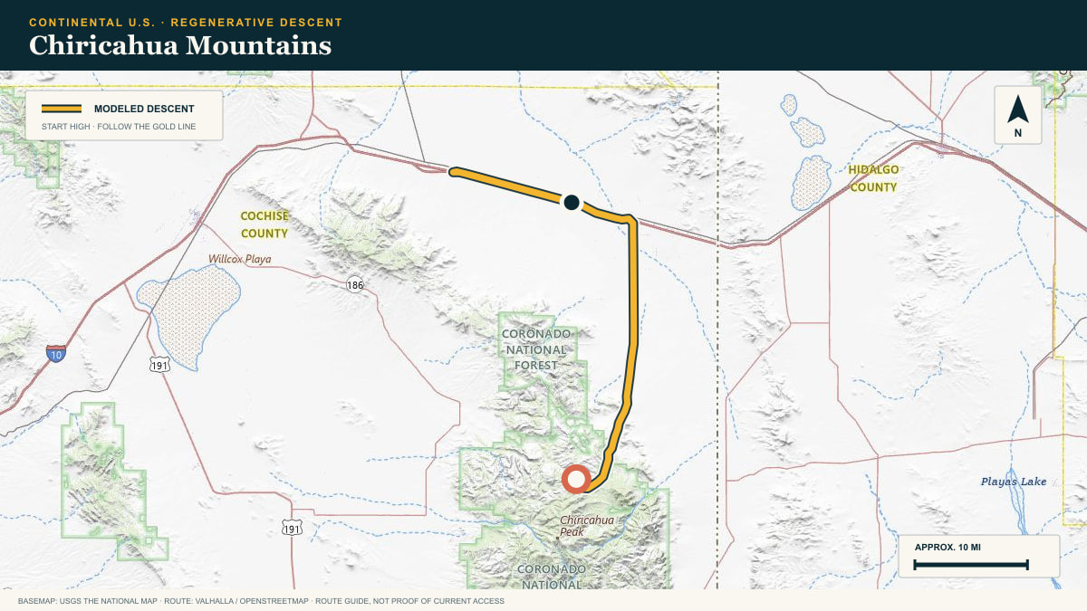
Chiricahua Mountains
Rustler Park Road out of the Chiricahuas
WHAT THIS ROAD SHOWS
The Chiricahuas rise alone out of southeastern Arizona’s grass seas. From Rustler Park the road spirals down through five life zones to the valley floor.
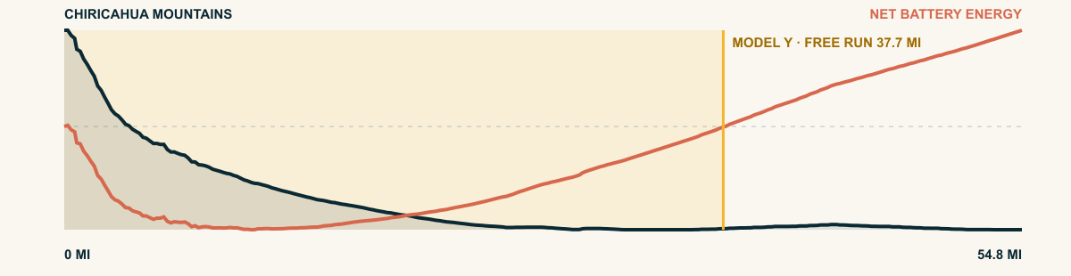
For the 2026 Model Y Premium AWD, the model shows that the battery stays at or above its starting charge for 37.7 of 54.8 road miles. The highest energy surplus is 2.6 kWh. This equals about 9.5 miles at the EPA energy rate. The result shows how the road grade and speed can reduce net energy use.
- Battery-hold miles
- 37.7
- Route length
- 54.8 mi
- Share of route
- 69%
- Total descent
- 4,388 ft
- Peak surplus
- 2.6 kWh
- EPA-eq. banked
- 9.5 mi
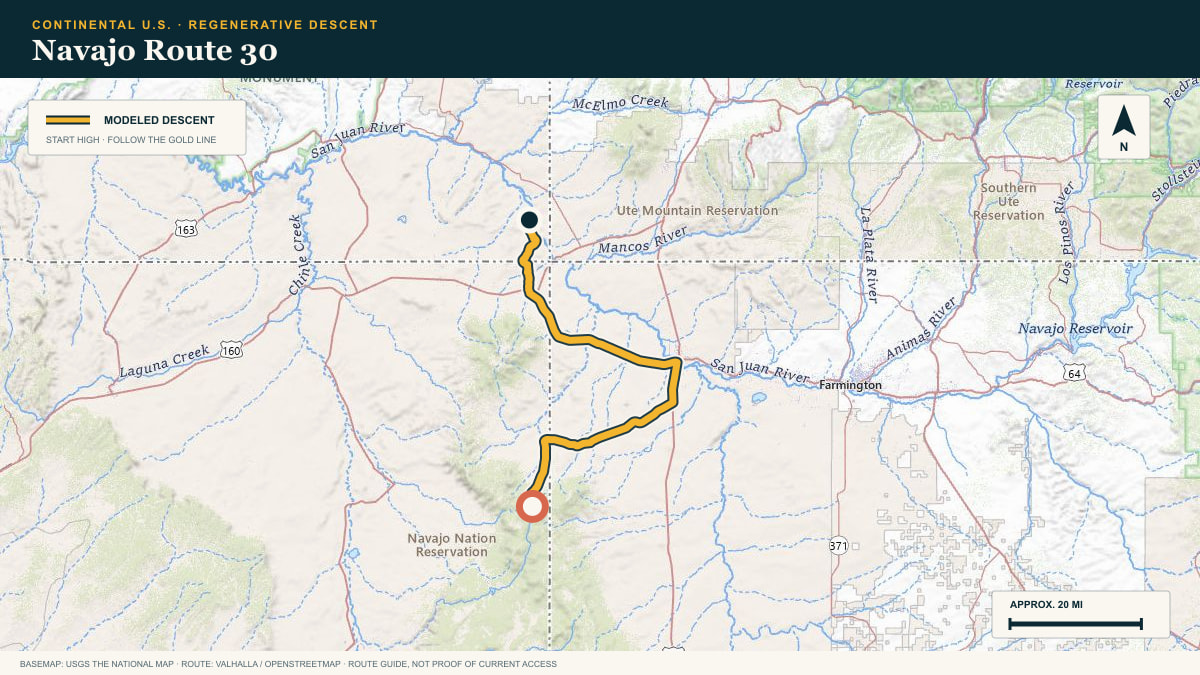
#44 / NAVAJO NATION, ARIZONA / UTAH, USA
Navajo Route 30
Navajo Route 30 → San Juan County
WHAT THIS ROAD SHOWS
Forest and broken sandstone benches give way to a long northbound release. The route is remote, lightly marked, and defined less by one cliff than by miles of patient elevation loss.
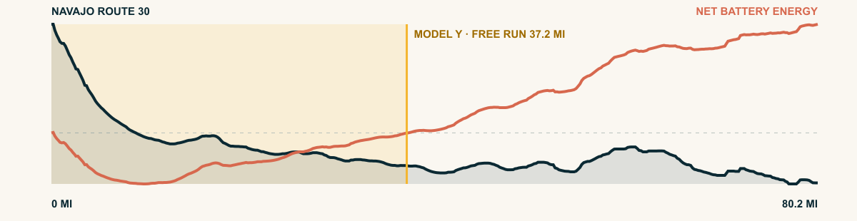
For the 2026 Model Y Premium AWD, the model shows that the battery stays at or above its starting charge for 37.2 of 80.2 road miles. The highest energy surplus is 3 kWh. This equals about 10.9 miles at the EPA energy rate. The result shows how the road grade and speed can reduce net energy use.
- Battery-hold miles
- 37.2
- Route length
- 80.2 mi
- Share of route
- 46%
- Total descent
- 6,893 ft
- Peak surplus
- 3 kWh
- EPA-eq. banked
- 10.9 mi
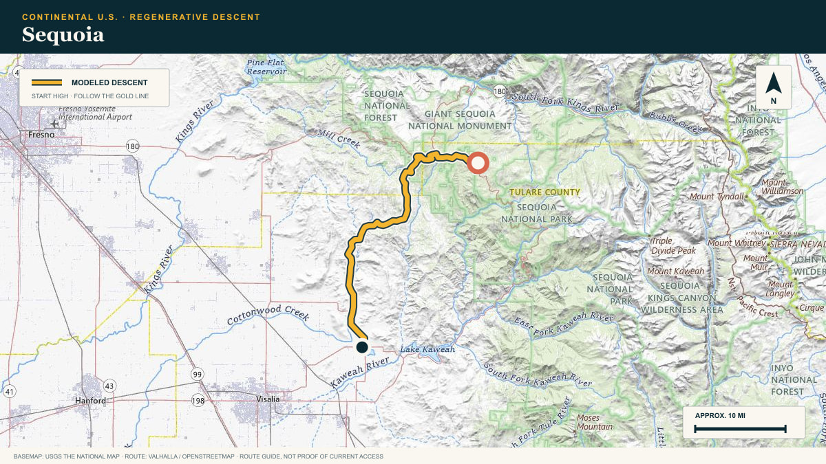
#45 / CALIFORNIA, USA
Sequoia
Generals Highway → Sierra Foothills
WHAT THIS ROAD SHOWS
Leaving the Giant Forest, the Generals Highway descends the western slope of the Sierra in one continuous run toward the orange groves of the Central Valley.
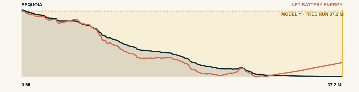
For the 2026 Model Y Premium AWD, the model shows that the battery stays at or above its starting charge for 37.2 of 37.2 road miles. The highest energy surplus is 5 kWh. This equals about 18.3 miles at the EPA energy rate. The result shows how the road grade and speed can reduce net energy use.
- Battery-hold miles
- 37.2
- Route length
- 37.2 mi
- Share of route
- 100%
- Total descent
- 7,507 ft
- Peak surplus
- 5 kWh
- EPA-eq. banked
- 18.3 mi
#46 / CHIAPAS, MEXICO
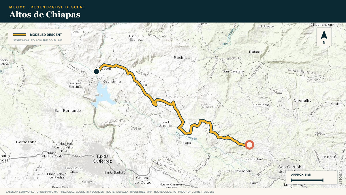
Altos de Chiapas
off the San Cristóbal highlands toward the Grijalva depression
WHAT THIS ROAD SHOWS
Maya highland country. The route leaves the misty plateau of Los Altos and falls toward the hot Grijalva valley, trading pine and fog for tropical scrub in under an hour.
For the 2026 Model Y Premium AWD, the model shows that the battery stays at or above its starting charge for 37 of 37 road miles. The highest energy surplus is 4.1 kWh. This equals about 15.1 miles at the EPA energy rate. The result shows how the road grade and speed can reduce net energy use.
- Battery-hold miles
- 37
- Route length
- 37 mi
- Share of route
- 100%
- Total descent
- 8,493 ft
- Peak surplus
- 4.1 kWh
- EPA-eq. banked
- 15.1 mi
#47 / OAXACA, MEXICO
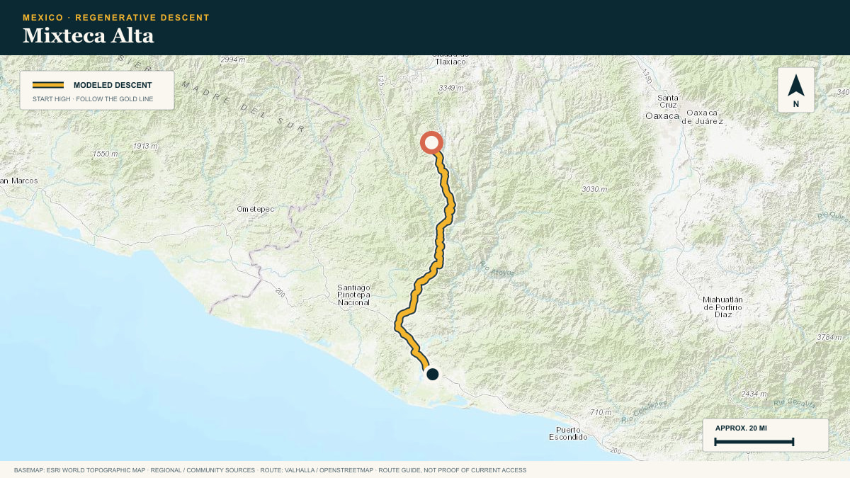
Mixteca Alta
the Mixteca back roads toward Putla
WHAT THIS ROAD SHOWS
The high Mixteca is a country of eroded ridgelines and deep barrancas. No single plunge: the road loses, regains, and loses altitude again all the way to the tropical southwest.
For the 2026 Model Y Premium AWD, the model shows that the battery stays at or above its starting charge for 36.5 of 78.5 road miles. The highest energy surplus is 4 kWh. This equals about 14.7 miles at the EPA energy rate. The result shows how the road grade and speed can reduce net energy use.
- Battery-hold miles
- 36.5
- Route length
- 78.5 mi
- Share of route
- 46%
- Total descent
- 16,374 ft
- Peak surplus
- 4 kWh
- EPA-eq. banked
- 14.7 mi
#48 / UTAH, USA
Bruin Point
Water Canyon Road → Castle Valley
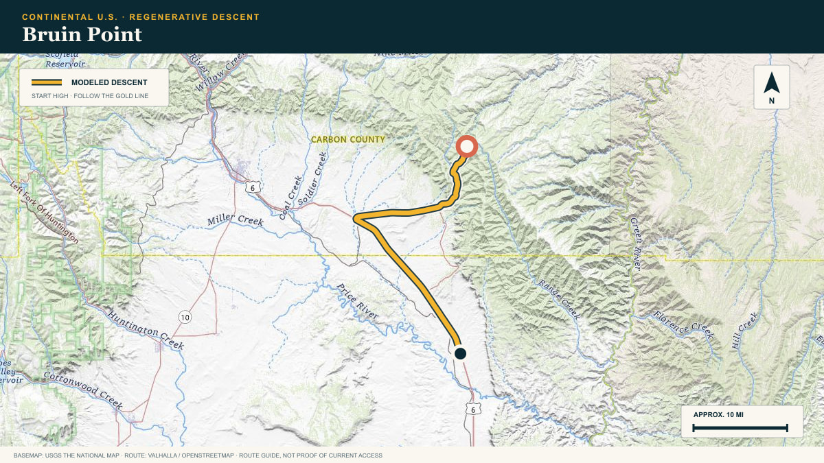
WHAT THIS ROAD SHOWS
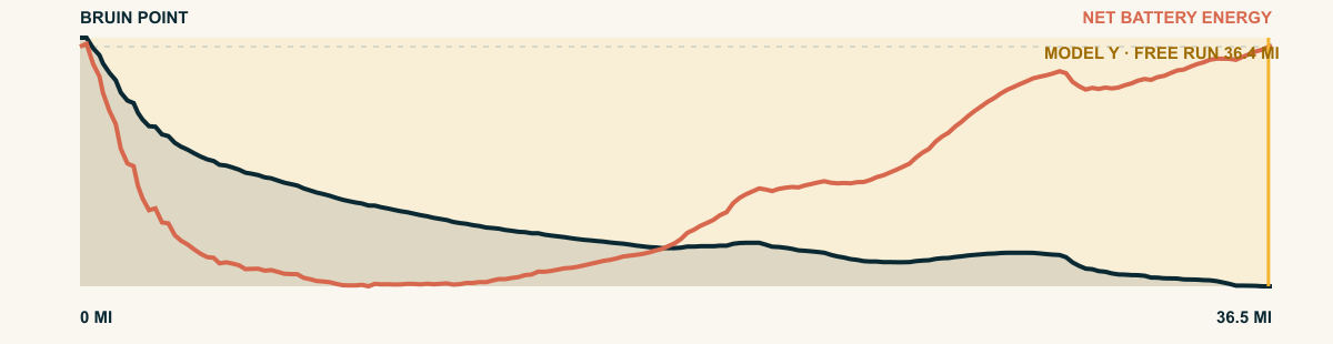
The road drops from cool forest into the bare, folded country north of the San Rafael Swell. Mining roads and canyon rims carry the line toward the desert floor.
For the 2026 Model Y Premium AWD, the model shows that the battery stays at or above its starting charge for 36.4 of 36.5 road miles. The highest energy surplus is 2.7 kWh. This equals about 9.8 miles at the EPA energy rate. The result shows how the road grade and speed can reduce net energy use.
- Battery-hold miles
- 36.4
- Route length
- 36.5 mi
- Share of route
- 100%
- Total descent
- 5,113 ft
- Peak surplus
- 2.7 kWh
- EPA-eq. banked
- 9.8 mi
#49 / NEVADA / CALIFORNIA, USA
Spring Mountains
Deer Creek Road → Death Valley
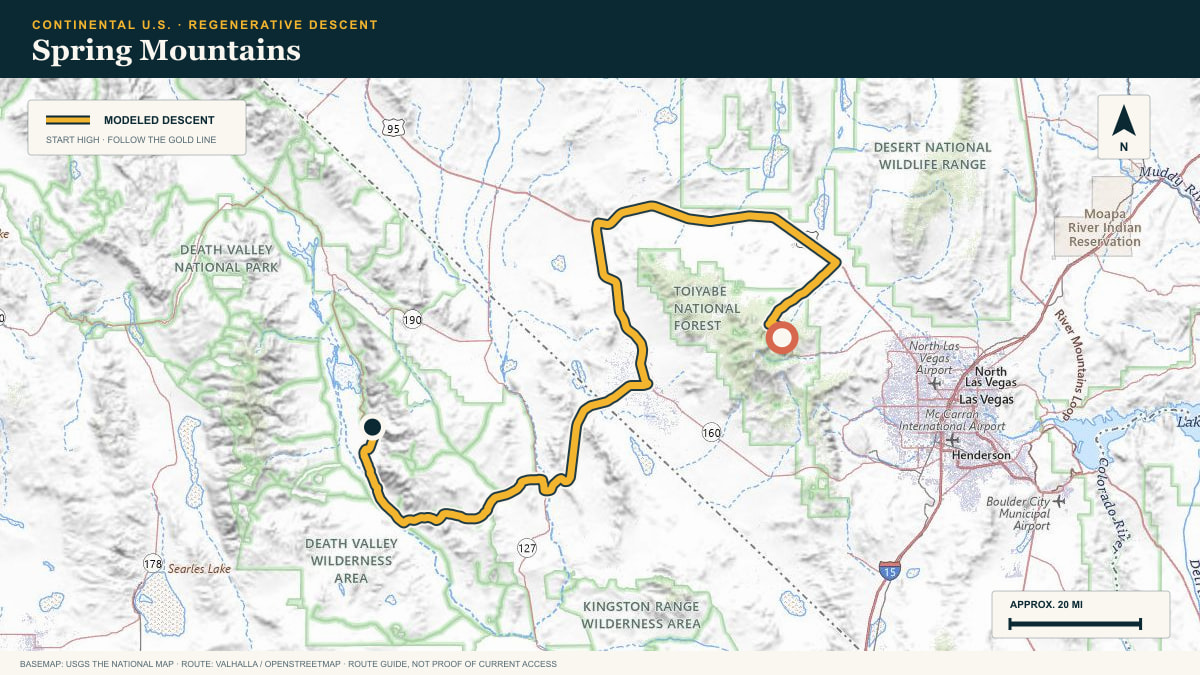
WHAT THIS ROAD SHOWS
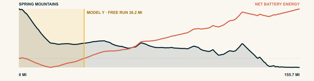
A high forest island gives way to Mojave basin after basin. The route drops from the Spring Mountains, crosses the desert west of Las Vegas, and keeps spending altitude toward one of the lowest landscapes in North America.
For the 2026 Model Y Premium AWD, the model shows that the battery stays at or above its starting charge for 36.2 of 155.7 road miles. The highest energy surplus is 3.3 kWh. This equals about 12.2 miles at the EPA energy rate. The result shows how the road grade and speed can reduce net energy use.
- Battery-hold miles
- 36.2
- Route length
- 155.7 mi
- Share of route
- 23%
- Total descent
- 12,748 ft
- Peak surplus
- 3.3 kWh
- EPA-eq. banked
- 12.2 mi
#50 / JALISCO, MEXICO
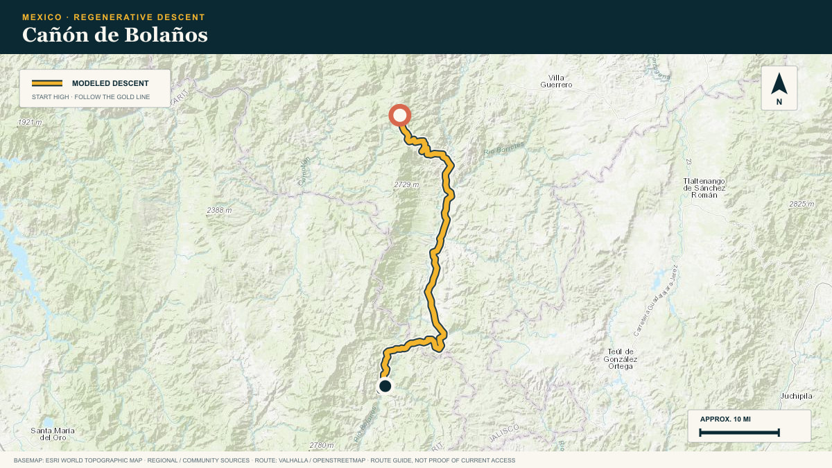
Cañón de Bolaños
JAL-711 into the Bolaños canyon
WHAT THIS ROAD SHOWS
A plunge into one of Mexico’s great forgotten canyons. Off the plateau the highway drops toward the river town of San Martín de Bolaños, heat rising to meet it.
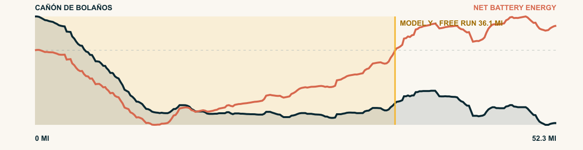
For the 2026 Model Y Premium AWD, the model shows that the battery stays at or above its starting charge for 36.1 of 52.3 road miles. The highest energy surplus is 5.3 kWh. This equals about 19.5 miles at the EPA energy rate. The result shows how the road grade and speed can reduce net energy use.
- Battery-hold miles
- 36.1
- Route length
- 52.3 mi
- Share of route
- 69%
- Total descent
- 9,810 ft
- Peak surplus
- 5.3 kWh
- EPA-eq. banked
- 19.5 mi
#51 / CALIFORNIA, USA
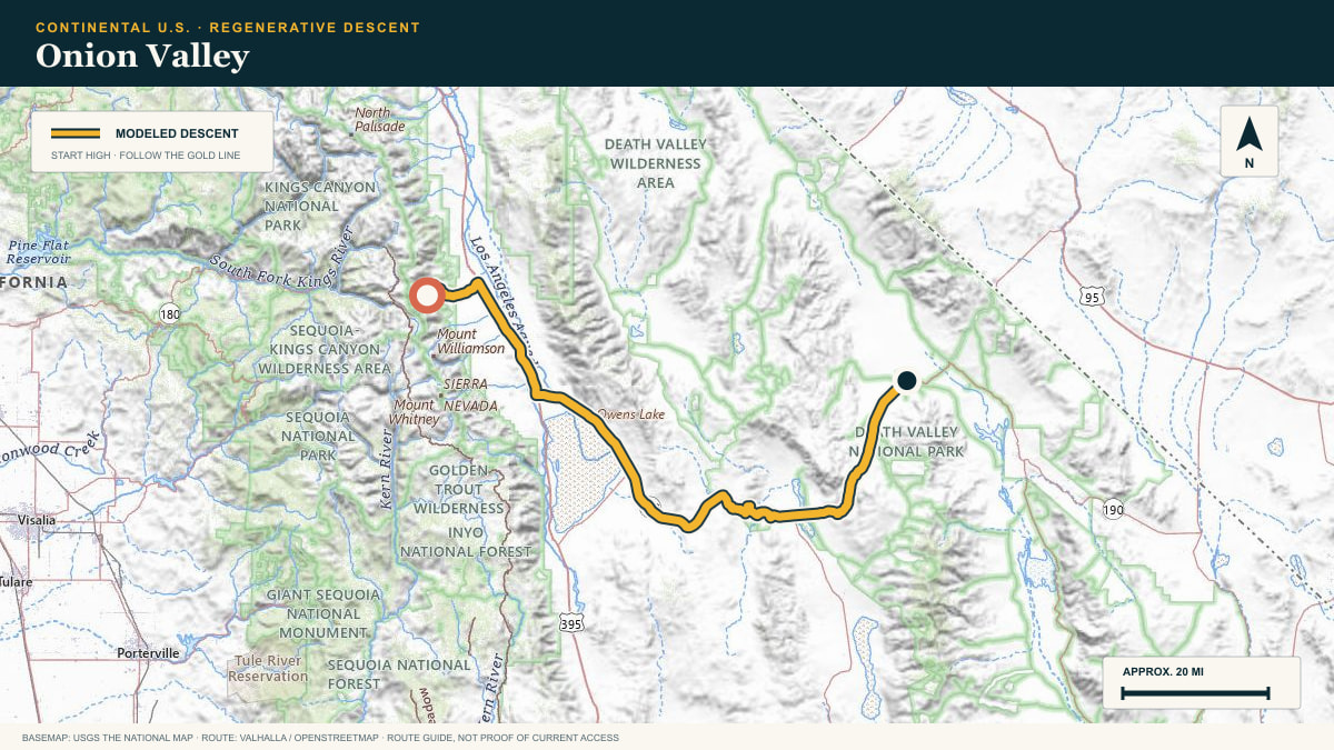
Onion Valley
Onion Valley Road → Death Valley
WHAT THIS ROAD SHOWS
The first plunge reaches the Owens Valley in a rush of switchbacks. The road then turns across the rain shadow and spends the remaining elevation on the approach to Stovepipe Wells.
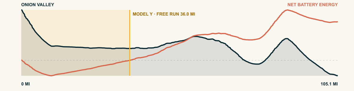
For the 2026 Model Y Premium AWD, the model shows that the battery stays at or above its starting charge for 36 of 105.1 road miles. The highest energy surplus is 4.3 kWh. This equals about 15.8 miles at the EPA energy rate. The result shows how the road grade and speed can reduce net energy use.
- Battery-hold miles
- 36
- Route length
- 105.1 mi
- Share of route
- 34%
- Total descent
- 14,102 ft
- Peak surplus
- 4.3 kWh
- EPA-eq. banked
- 15.8 mi
#52 / WYOMING, USA
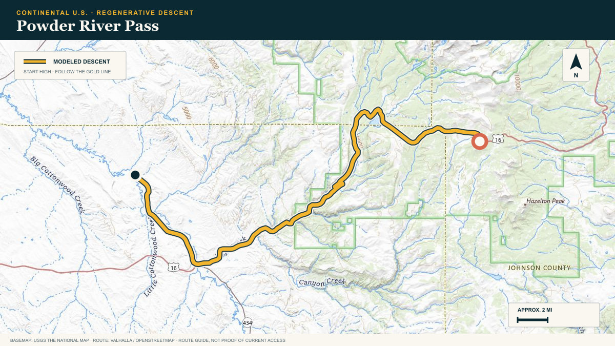
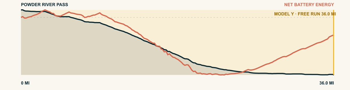
Powder River Pass
US-16 · Powder River Pass → Nowood Basin
WHAT THIS ROAD SHOWS
From open alpine ground, the highway descends through lodgepole and limestone walls into the dry country west of the range. The grade eases near the basin, but the road continues downhill for miles.
For the 2026 Model Y Premium AWD, the model shows that the battery stays at or above its starting charge for 36 of 36 road miles. The highest energy surplus is 2.3 kWh. This equals about 8.4 miles at the EPA energy rate. The result shows how the road grade and speed can reduce net energy use.
- Battery-hold miles
- 36
- Route length
- 36 mi
- Share of route
- 100%
- Total descent
- 5,344 ft
- Peak surplus
- 2.3 kWh
- EPA-eq. banked
- 8.4 mi
#53 / COLORADO, USA
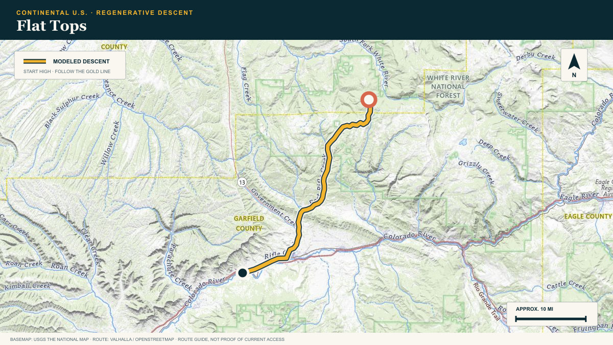
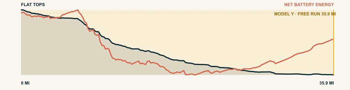
Flat Tops
the Buford–New Castle Road off the White River Plateau
WHAT THIS ROAD SHOWS
Colorado’s Flat Tops are a lava-capped plateau of meadow and spruce. The old Buford road slides off the south rim and follows Elk Creek down to the Colorado River valley.
For the 2026 Model Y Premium AWD, the model shows that the battery stays at or above its starting charge for 35.9 of 35.9 road miles. The highest energy surplus is 2.2 kWh. This equals about 8.2 miles at the EPA energy rate. The result shows how the road grade and speed can reduce net energy use.
- Battery-hold miles
- 35.9
- Route length
- 35.9 mi
- Share of route
- 100%
- Total descent
- 4,960 ft
- Peak surplus
- 2.2 kWh
- EPA-eq. banked
- 8.2 mi
#54 / COLORADO, USA
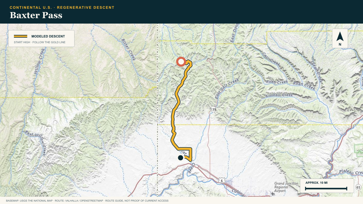
Baxter Pass
Baxter Pass Road → Colorado River country
WHAT THIS ROAD SHOWS
This is a backroad descent rather than a polished scenic byway. The track leaves the high Book Cliffs, follows dry washes and benches, and eventually reaches the broad Colorado River valley.
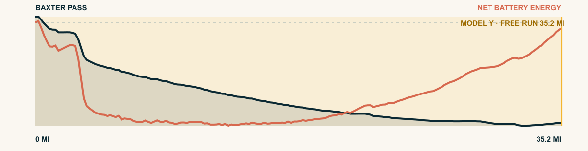
For the 2026 Model Y Premium AWD, the model shows that the battery stays at or above its starting charge for 35.2 of 35.2 road miles. The highest energy surplus is 1.7 kWh. This equals about 6.3 miles at the EPA energy rate. The result shows how the road grade and speed can reduce net energy use.
- Battery-hold miles
- 35.2
- Route length
- 35.2 mi
- Share of route
- 100%
- Total descent
- 3,676 ft
- Peak surplus
- 1.7 kWh
- EPA-eq. banked
- 6.3 mi
#55 / OAXACA, MEXICO
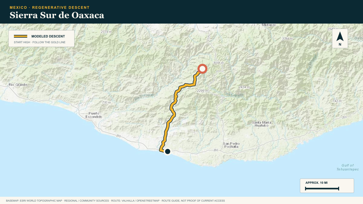
Sierra Sur de Oaxaca
MEX-175 · San José del Pacífico → Pochutla
WHAT THIS ROAD SHOWS
Out of the fog belt at San José del Pacífico, Highway 175 corkscrews off the Sierra Sur toward the coastal junction at Pochutla.
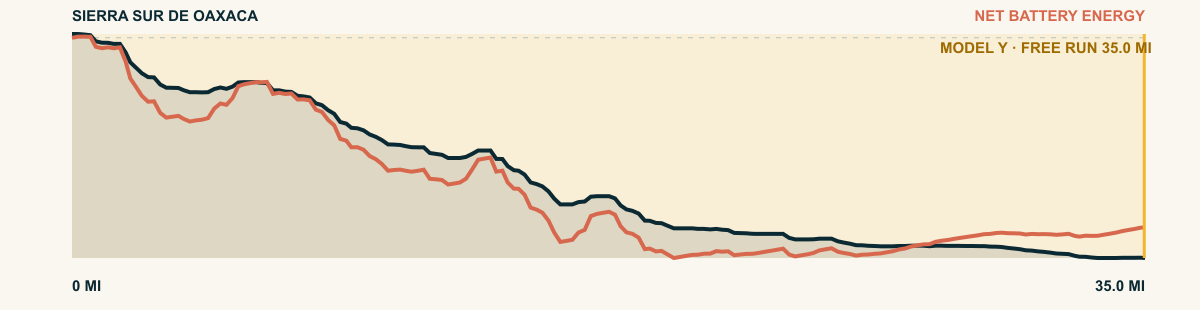
For the 2026 Model Y Premium AWD, the model shows that the battery stays at or above its starting charge for 35 of 35 road miles. The highest energy surplus is 5.9 kWh. This equals about 21.4 miles at the EPA energy rate. The result shows how the road grade and speed can reduce net energy use.
- Battery-hold miles
- 35
- Route length
- 35 mi
- Share of route
- 100%
- Total descent
- 9,544 ft
- Peak surplus
- 5.9 kWh
- EPA-eq. banked
- 21.4 mi
#56 / CALIFORNIA, USA
South Lake
South Lake Road → Death Valley
WHAT THIS ROAD SHOWS
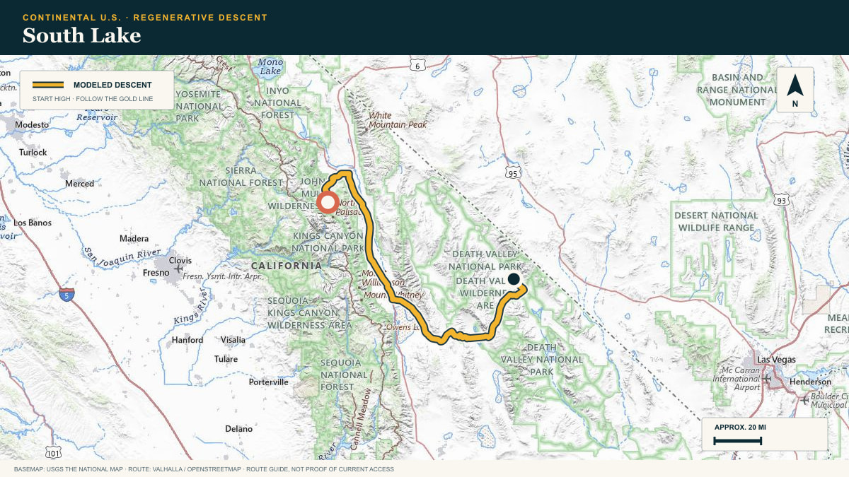
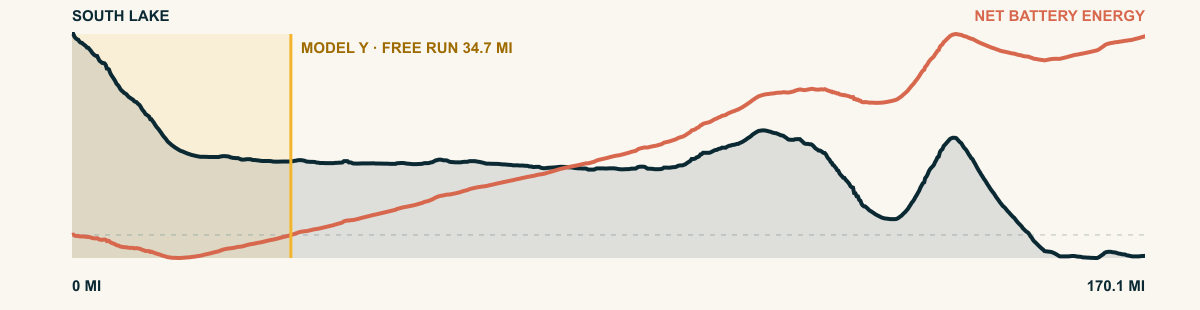
Bishop Creek supplies the first steep descent. After the canyon opens, the route runs the length of the Owens Valley and turns east, carrying its early energy credit toward the desert floor.
For the 2026 Model Y Premium AWD, the model shows that the battery stays at or above its starting charge for 34.7 of 170.1 road miles. The highest energy surplus is 2.9 kWh. This equals about 10.5 miles at the EPA energy rate. The result shows how the road grade and speed can reduce net energy use.
- Battery-hold miles
- 34.7
- Route length
- 170.1 mi
- Share of route
- 20%
- Total descent
- 15,351 ft
- Peak surplus
- 2.9 kWh
- EPA-eq. banked
- 10.5 mi
#57 / BRITISH COLUMBIA, CANADA
Big White
Big White Road · Big White → Kelowna
WHAT THIS ROAD SHOWS
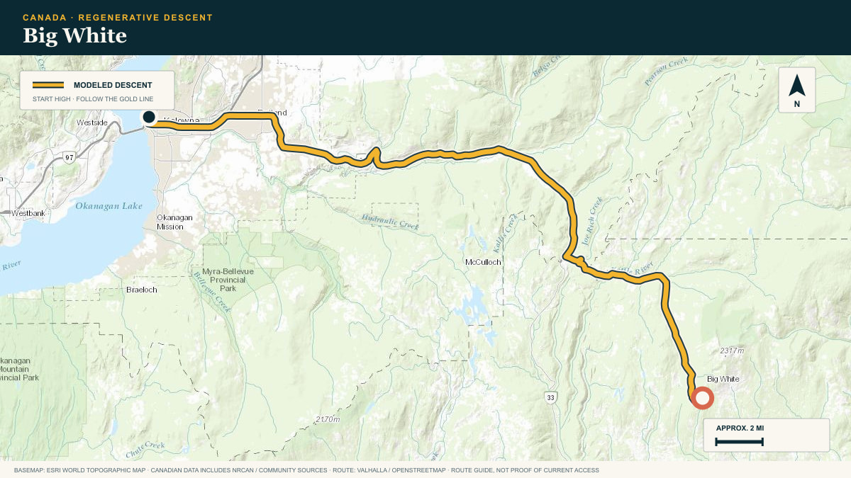
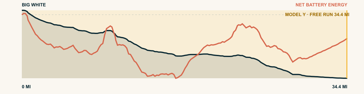
The resort road descends from the alpine area in long steps. It joins Highway 33 and continues through Joe Rich to the Okanagan Valley at Kelowna.
For the 2026 Model Y Premium AWD, the model shows that the battery stays at or above its starting charge for 34.4 of 34.4 road miles. The highest energy surplus is 1.4 kWh. This equals about 5.2 miles at the EPA energy rate. The result shows how the road grade and speed can reduce net energy use.
- Battery-hold miles
- 34.4
- Route length
- 34.4 mi
- Share of route
- 100%
- Total descent
- 5,125 ft
- Peak surplus
- 1.4 kWh
- EPA-eq. banked
- 5.2 mi
#58 / COLORADO, USA
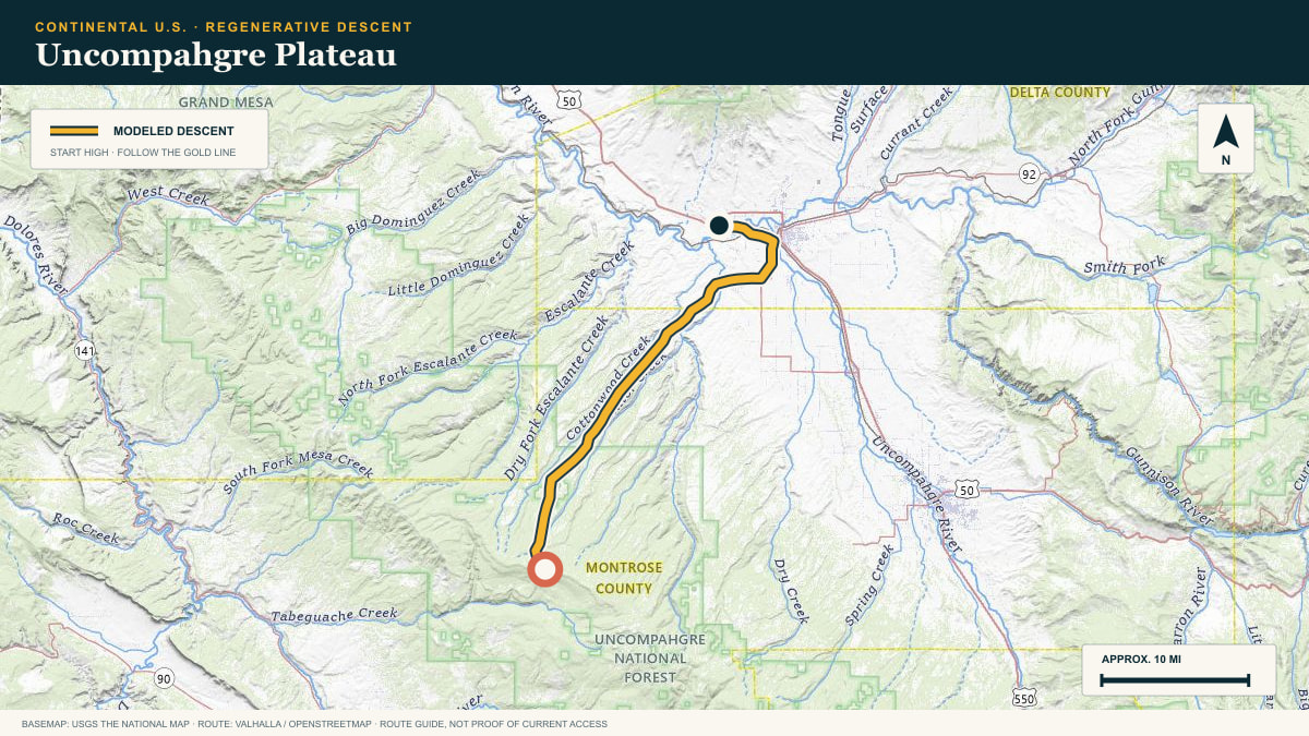
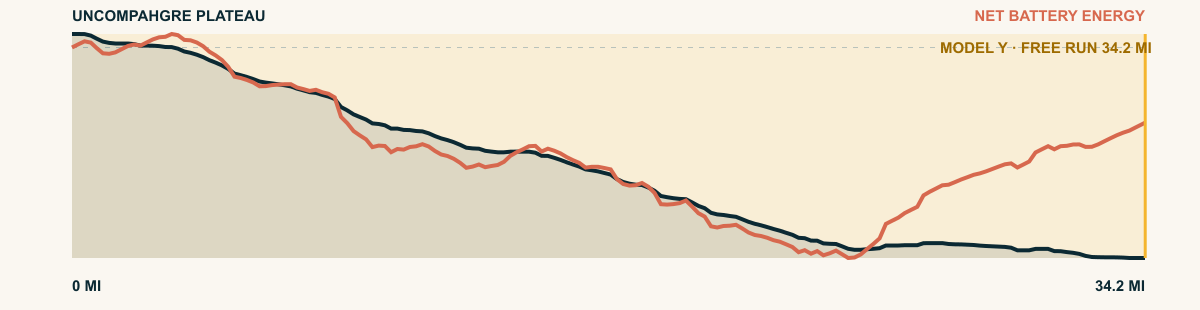
Uncompahgre Plateau
Divide Road off the Uncompahgre
WHAT THIS ROAD SHOWS
A long wooded ramp in western Colorado. Divide Road runs the spine, then the descent breaks off the rim toward the adobe badlands of the Uncompahgre Valley.
For the 2026 Model Y Premium AWD, the model shows that the battery stays at or above its starting charge for 34.2 of 34.2 road miles. The highest energy surplus is 1.9 kWh. This equals about 6.8 miles at the EPA energy rate. The result shows how the road grade and speed can reduce net energy use.
- Battery-hold miles
- 34.2
- Route length
- 34.2 mi
- Share of route
- 100%
- Total descent
- 4,589 ft
- Peak surplus
- 1.9 kWh
- EPA-eq. banked
- 6.8 mi
#59 / UTAH, USA
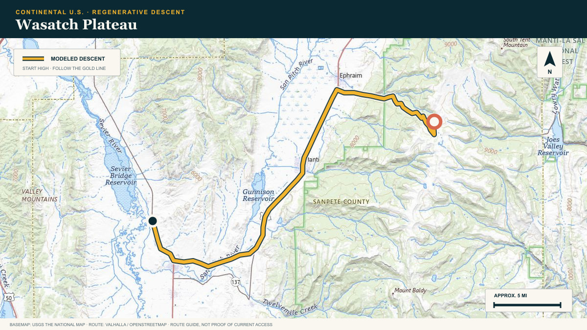
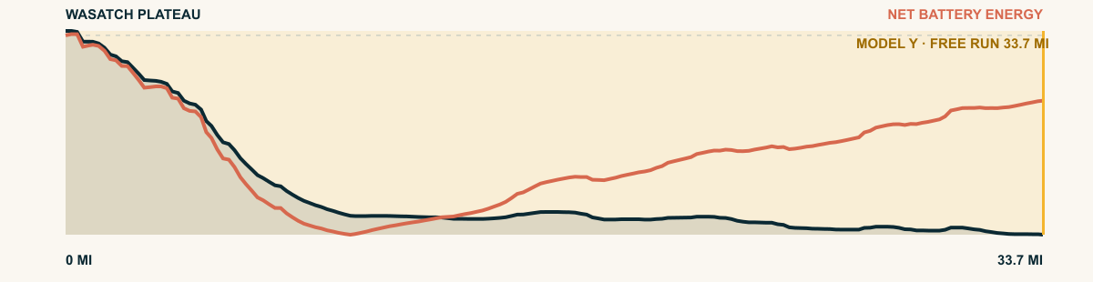
Wasatch Plateau
Ephraim Canyon Road off Skyline Drive
WHAT THIS ROAD SHOWS
A tableland, not a peak: the Wasatch Plateau holds its altitude for miles before Ephraim Canyon cuts the exit. Short, steep, and efficient — 5,700 ft down to the Sanpete Valley floor.
For the 2026 Model Y Premium AWD, the model shows that the battery stays at or above its starting charge for 33.7 of 33.7 road miles. The highest energy surplus is 4.5 kWh. This equals about 16.3 miles at the EPA energy rate. The result shows how the road grade and speed can reduce net energy use.
- Battery-hold miles
- 33.7
- Route length
- 33.7 mi
- Share of route
- 100%
- Total descent
- 5,511 ft
- Peak surplus
- 4.5 kWh
- EPA-eq. banked
- 16.3 mi
#60 / VERACRUZ, MEXICO
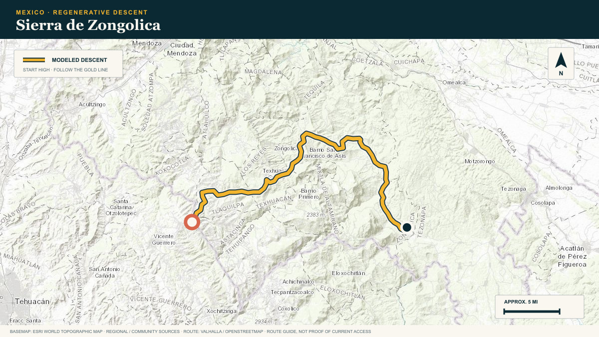
Sierra de Zongolica
the Zongolica mountain roads above the Orizaba valley
WHAT THIS ROAD SHOWS
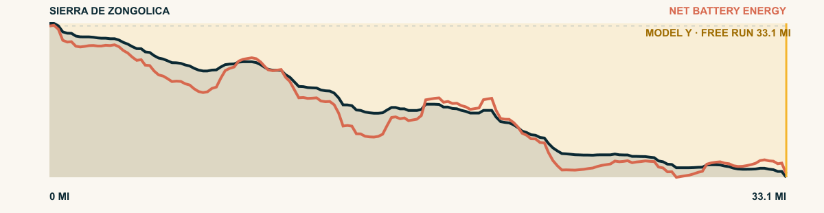
A crumpled Nahua highland south of Orizaba where every road is a grade. This one sheds 13,000 cumulative feet working down toward the sugar country of the valley floor.
For the 2026 Model Y Premium AWD, the model shows that the battery stays at or above its starting charge for 33.1 of 33.1 road miles. The highest energy surplus is 5.7 kWh. This equals about 20.8 miles at the EPA energy rate. The result shows how the road grade and speed can reduce net energy use.
- Battery-hold miles
- 33.1
- Route length
- 33.1 mi
- Share of route
- 100%
- Total descent
- 10,568 ft
- Peak surplus
- 5.7 kWh
- EPA-eq. banked
- 20.8 mi
#61 / CALIFORNIA, USA
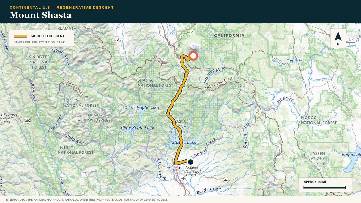
Mount Shasta
Everitt Memorial Highway → Shasta Valley
WHAT THIS ROAD SHOWS
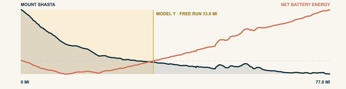
The road falls through red fir and volcanic clearings to the town of Mount Shasta, then continues south along the mountain’s long apron. The peak stays in the mirrors while the elevation keeps unwinding.
For the 2026 Model Y Premium AWD, the model shows that the battery stays at or above its starting charge for 33 of 77 road miles. The highest energy surplus is 2.2 kWh. This equals about 8.2 miles at the EPA energy rate. The result shows how the road grade and speed can reduce net energy use.
- Battery-hold miles
- 33
- Route length
- 77 mi
- Share of route
- 43%
- Total descent
- 8,314 ft
- Peak surplus
- 2.2 kWh
- EPA-eq. banked
- 8.2 mi
#62 / COLORADO, USA
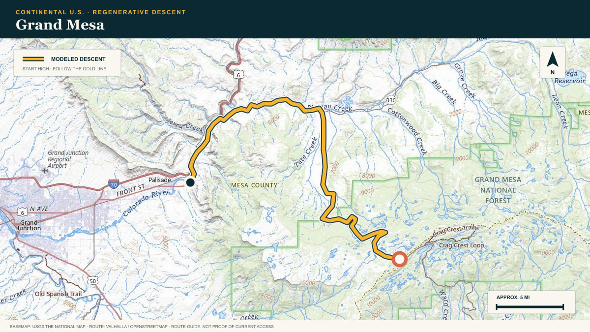
Grand Mesa
Grand Mesa Scenic Byway (CO-65)
WHAT THIS ROAD SHOWS
A mile-high basalt table between two river valleys. The byway rolls off the lake-dotted summit and descends 7,200 cumulative feet to the adobe hills of the Gunnison.
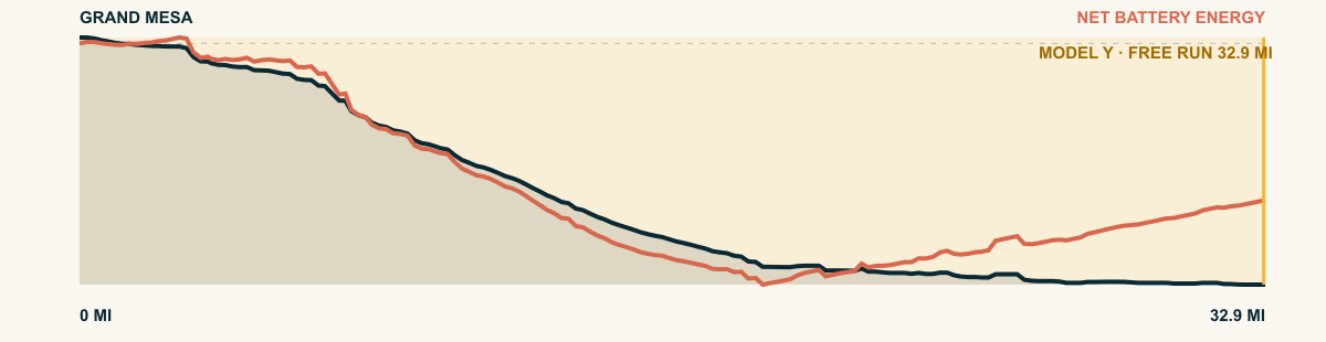
For the 2026 Model Y Premium AWD, the model shows that the battery stays at or above its starting charge for 32.9 of 32.9 road miles. The highest energy surplus is 4.5 kWh. This equals about 16.4 miles at the EPA energy rate. The result shows how the road grade and speed can reduce net energy use.
- Battery-hold miles
- 32.9
- Route length
- 32.9 mi
- Share of route
- 100%
- Total descent
- 6,362 ft
- Peak surplus
- 4.5 kWh
- EPA-eq. banked
- 16.4 mi
#63 / UTAH, USA
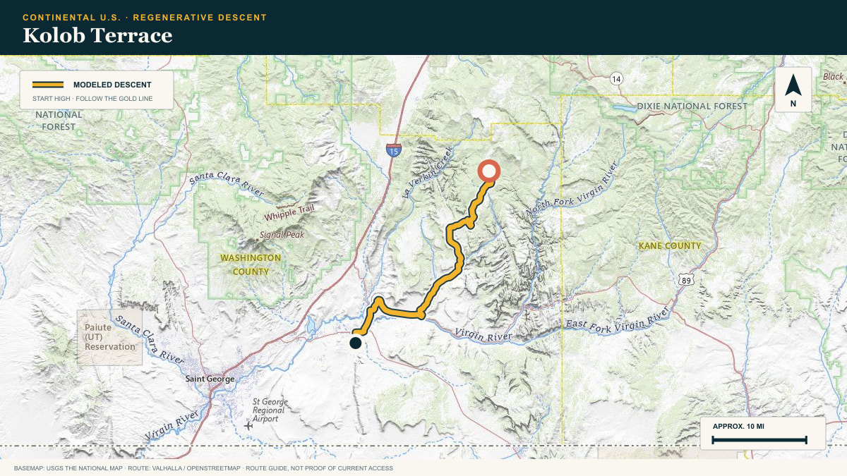
Kolob Terrace
Kolob Terrace Road → Hurricane
WHAT THIS ROAD SHOWS
The pavement rolls off Zion’s western plateau and follows a staircase of mesas toward Hurricane. Red cliffs gather around the road while the horizon opens toward the Mojave.
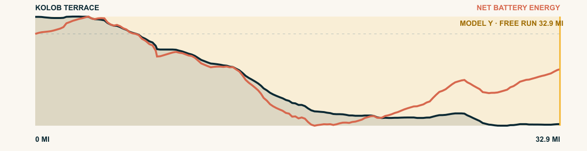
For the 2026 Model Y Premium AWD, the model shows that the battery stays at or above its starting charge for 32.9 of 32.9 road miles. The highest energy surplus is 2.7 kWh. This equals about 9.9 miles at the EPA energy rate. The result shows how the road grade and speed can reduce net energy use.
- Battery-hold miles
- 32.9
- Route length
- 32.9 mi
- Share of route
- 100%
- Total descent
- 5,106 ft
- Peak surplus
- 2.7 kWh
- EPA-eq. banked
- 9.9 mi
#64 / NEW MEXICO, USA
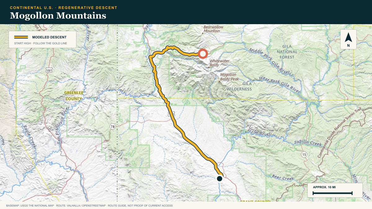
Mogollon Mountains
Bursum Road → Gila Valley
WHAT THIS ROAD SHOWS
The road begins among ponderosa and volcanic ridges, then follows a succession of canyons toward the Gila. Pavement is not the point here; remoteness and vertical scale are.
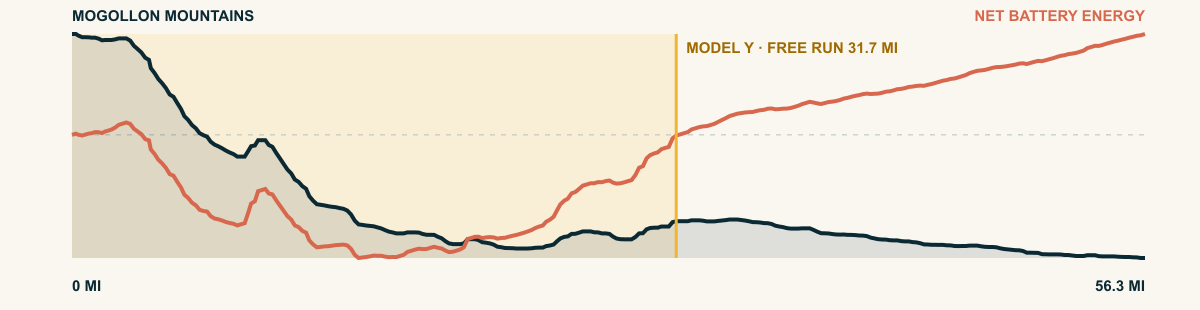
For the 2026 Model Y Premium AWD, the model shows that the battery stays at or above its starting charge for 31.7 of 56.3 road miles. The highest energy surplus is 2.9 kWh. This equals about 10.5 miles at the EPA energy rate. The result shows how the road grade and speed can reduce net energy use.
- Battery-hold miles
- 31.7
- Route length
- 56.3 mi
- Share of route
- 56%
- Total descent
- 6,163 ft
- Peak surplus
- 2.9 kWh
- EPA-eq. banked
- 10.5 mi
#65 / ZACATECAS / DURANGO, MEXICO
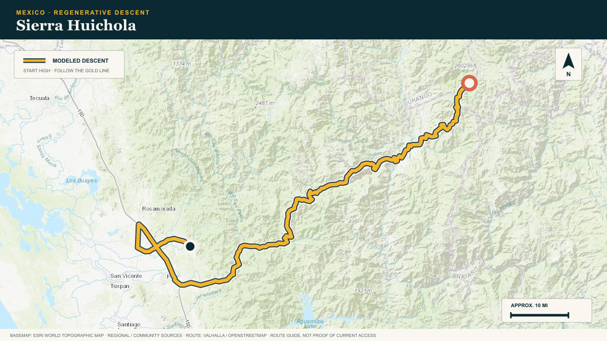
Sierra Huichola
the Valparaíso–Huejuquilla highway (DGO-44)
WHAT THIS ROAD SHOWS
West of Valparaíso the plateau ends and the great barranca country begins. The highway to Huejuquilla descends through it in long, patient switchback flights.
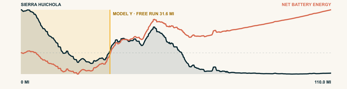
For the 2026 Model Y Premium AWD, the model shows that the battery stays at or above its starting charge for 31.6 of 110 road miles. The highest energy surplus is 5.3 kWh. This equals about 19.2 miles at the EPA energy rate. The result shows how the road grade and speed can reduce net energy use.
- Battery-hold miles
- 31.6
- Route length
- 110 mi
- Share of route
- 29%
- Total descent
- 16,703 ft
- Peak surplus
- 5.3 kWh
- EPA-eq. banked
- 19.2 mi
#66 / IDAHO, USA
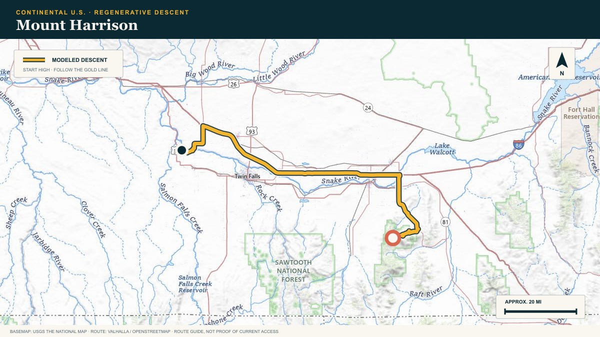
Mount Harrison
Mount Harrison Road → Snake River Plain
WHAT THIS ROAD SHOWS
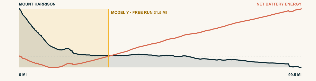
From an alpine island above southern Idaho, the road drops through ski slopes and sage. The route then stretches west across the plain, preserving enough early descent to keep the modeled run free.
For the 2026 Model Y Premium AWD, the model shows that the battery stays at or above its starting charge for 31.5 of 99.5 road miles. The highest energy surplus is 2.8 kWh. This equals about 10.2 miles at the EPA energy rate. The result shows how the road grade and speed can reduce net energy use.
- Battery-hold miles
- 31.5
- Route length
- 99.5 mi
- Share of route
- 32%
- Total descent
- 6,772 ft
- Peak surplus
- 2.8 kWh
- EPA-eq. banked
- 10.2 mi
#67 / COLORADO, USA
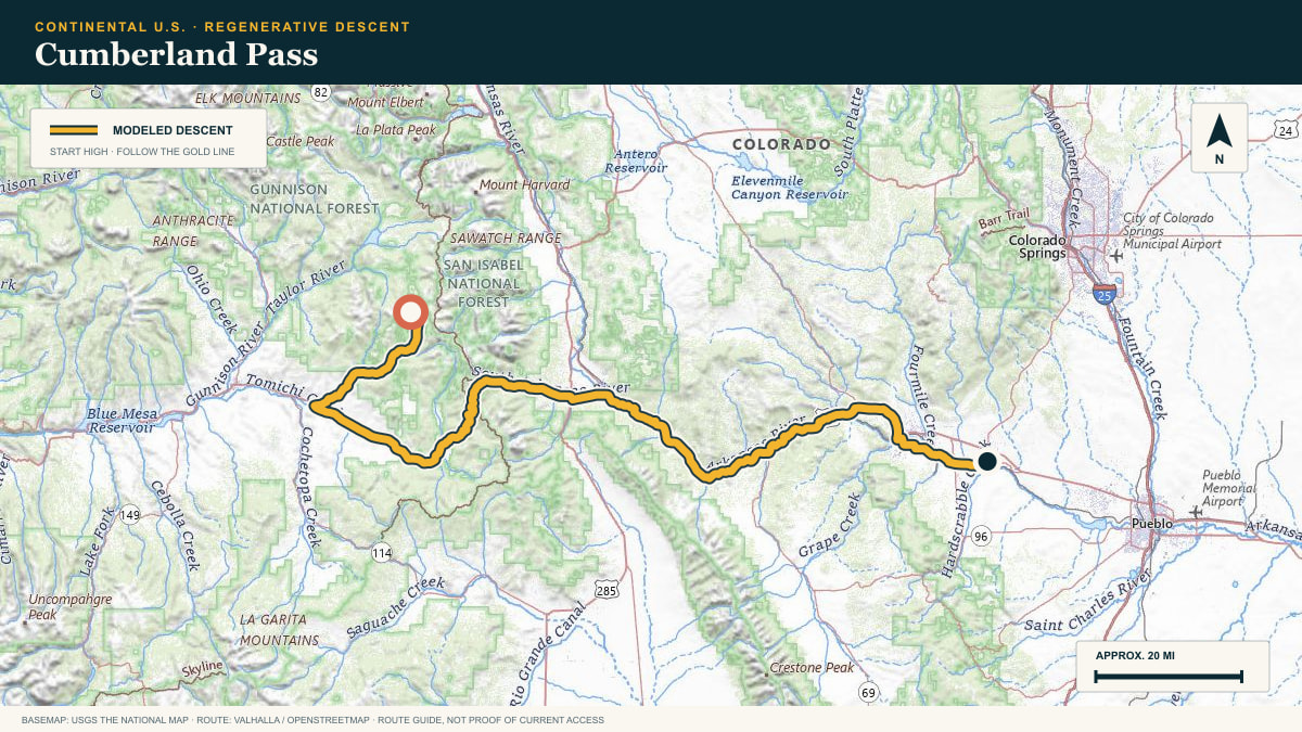
Cumberland Pass
Cumberland Pass Road → Arkansas River valley
WHAT THIS ROAD SHOWS
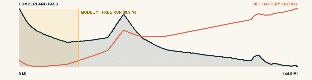
The first miles drop quickly from tundra into timber. From there the route keeps finding lower country—past old mining valleys, through the upper Arkansas corridor, and east toward the plains-facing edge of the Rockies.
For the 2026 Model Y Premium AWD, the model shows that the battery stays at or above its starting charge for 30.9 of 144.9 road miles. The highest energy surplus is 1.9 kWh. This equals about 6.8 miles at the EPA energy rate. The result shows how the road grade and speed can reduce net energy use.
- Battery-hold miles
- 30.9
- Route length
- 144.9 mi
- Share of route
- 21%
- Total descent
- 11,114 ft
- Peak surplus
- 1.9 kWh
- EPA-eq. banked
- 6.8 mi
#68 / BRITISH COLUMBIA, CANADA
Blueberry–Paulson Summit
Crowsnest Highway · Paulson Summit → Castlegar
WHAT THIS ROAD SHOWS
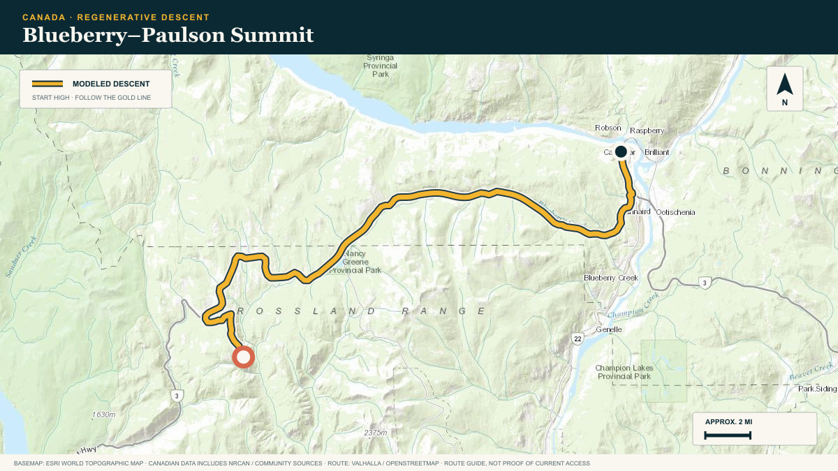
The Crowsnest Highway leaves the pass in dense forest. It crosses the Paulson Bridge and continues downhill toward the Columbia River near Castlegar.
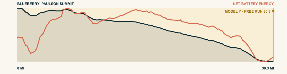
For the 2026 Model Y Premium AWD, the model shows that the battery stays at or above its starting charge for 30.3 of 30.3 road miles. The highest energy surplus is 0.7 kWh. This equals about 2.5 miles at the EPA energy rate. The result shows how the road grade and speed can reduce net energy use.
- Battery-hold miles
- 30.3
- Route length
- 30.3 mi
- Share of route
- 100%
- Total descent
- 4,137 ft
- Peak surplus
- 0.7 kWh
- EPA-eq. banked
- 2.5 mi
#69 / OAXACA, MEXICO
Mixteca de Peñoles
the Santa Catarina Ocotlán road
WHAT THIS ROAD SHOWS
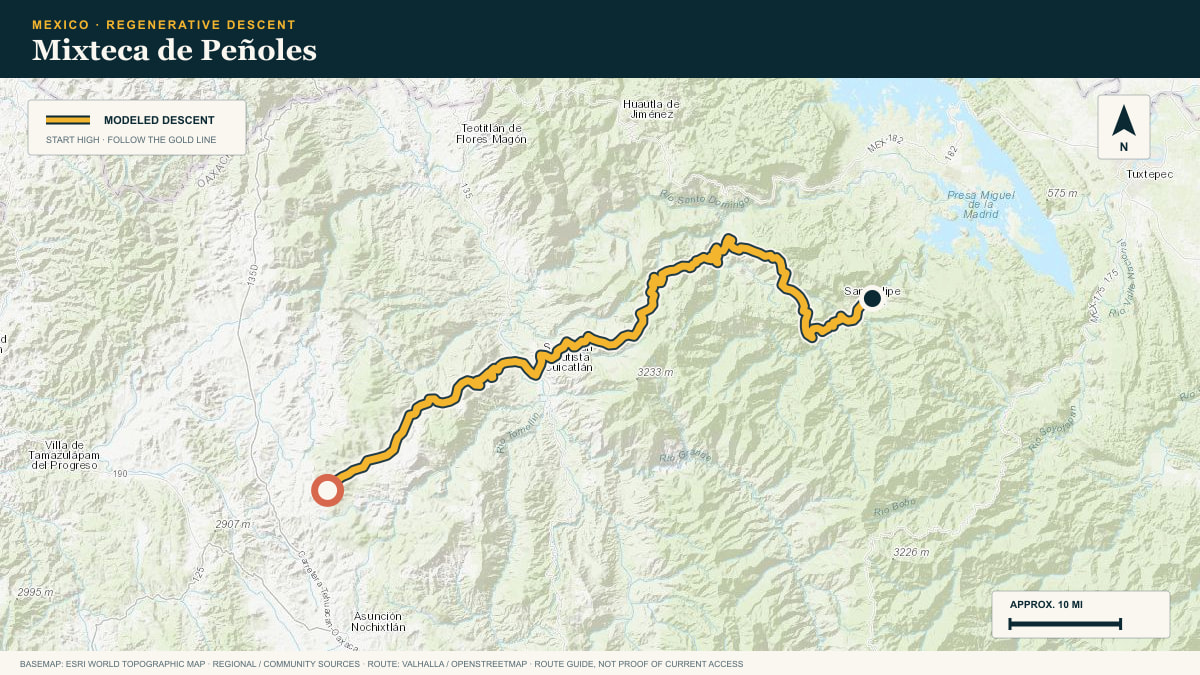
Deep Mixteca: eroded gold-and-green highlands cut by gorge after gorge. The road gives up its altitude a canyon at a time, all the way down to the Pacific slope.
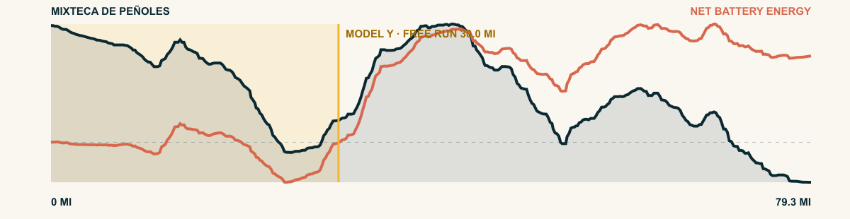
For the 2026 Model Y Premium AWD, the model shows that the battery stays at or above its starting charge for 30 of 79.3 road miles. The highest energy surplus is 3.9 kWh. This equals about 14.2 miles at the EPA energy rate. The result shows how the road grade and speed can reduce net energy use.
- Battery-hold miles
- 30
- Route length
- 79.3 mi
- Share of route
- 38%
- Total descent
- 20,167 ft
- Peak surplus
- 3.9 kWh
- EPA-eq. banked
- 14.2 mi
#70 / UTAH, USA
La Sal Mountains
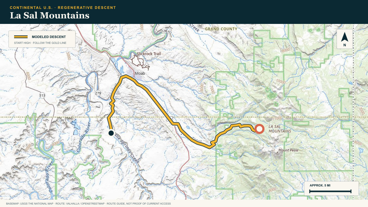
Geyser Pass Road toward the Moab valley
WHAT THIS ROAD SHOWS
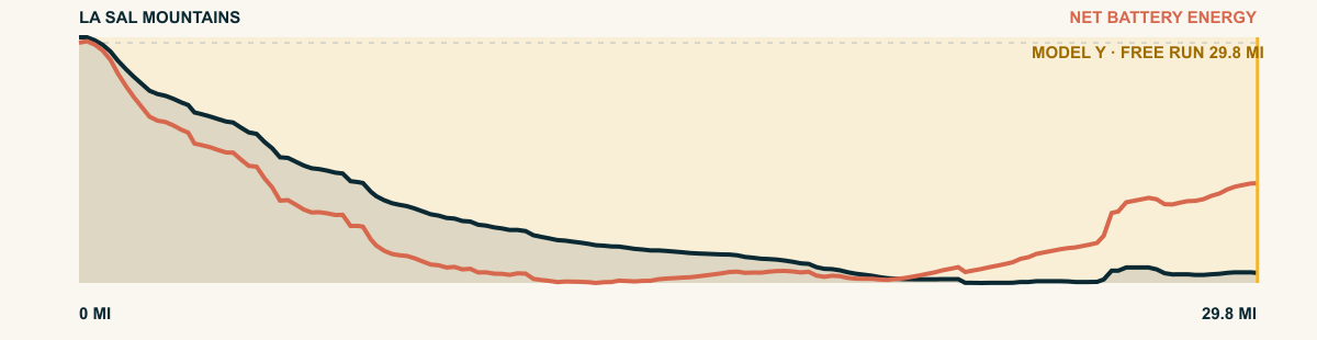
A laccolithic island range floating over redrock. The descent leaves the cool aspen belt and lands in the canyon country of the Colorado, 6,900 cumulative feet below.
For the 2026 Model Y Premium AWD, the model shows that the battery stays at or above its starting charge for 29.8 of 29.8 road miles. The highest energy surplus is 4.3 kWh. This equals about 15.8 miles at the EPA energy rate. The result shows how the road grade and speed can reduce net energy use.
- Battery-hold miles
- 29.8
- Route length
- 29.8 mi
- Share of route
- 100%
- Total descent
- 5,988 ft
- Peak surplus
- 4.3 kWh
- EPA-eq. banked
- 15.8 mi
#71 / NEVADA, USA
Hinkey Summit
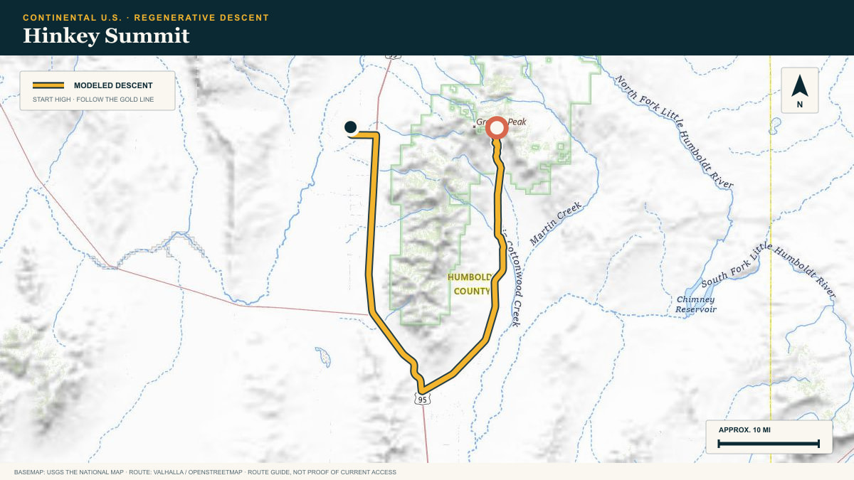
Hinkey Summit Road → Paradise Valley
WHAT THIS ROAD SHOWS
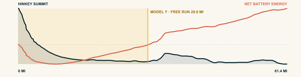
The road leaves open mountain slopes and points west into an immense basin. There are few landmarks and almost no traffic—just a steady loss of height beneath the Santa Rosas.
For the 2026 Model Y Premium AWD, the model shows that the battery stays at or above its starting charge for 29.6 of 61.4 road miles. The highest energy surplus is 2.4 kWh. This equals about 8.9 miles at the EPA energy rate. The result shows how the road grade and speed can reduce net energy use.
- Battery-hold miles
- 29.6
- Route length
- 61.4 mi
- Share of route
- 48%
- Total descent
- 4,184 ft
- Peak surplus
- 2.4 kWh
- EPA-eq. banked
- 8.9 mi
#72 / COLORADO, USA
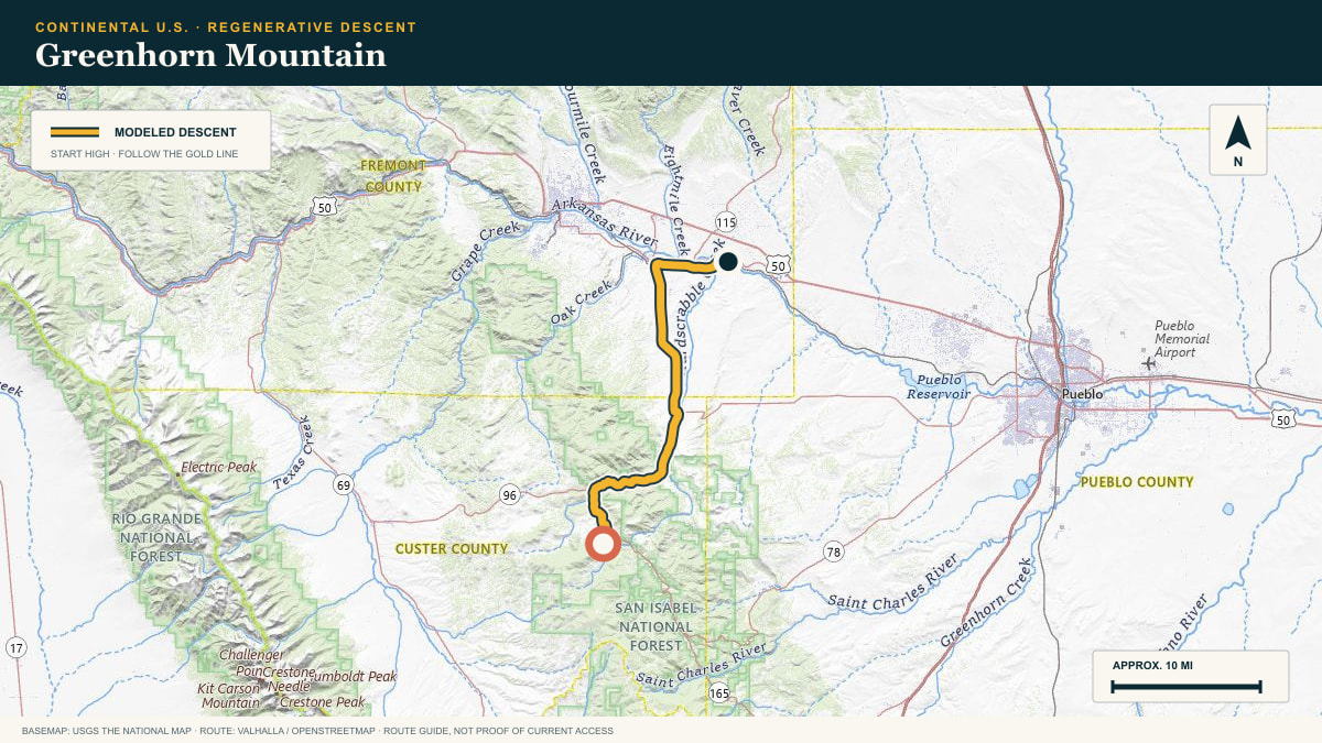
Greenhorn Mountain
Greenhorn Highway → Arkansas River
WHAT THIS ROAD SHOWS
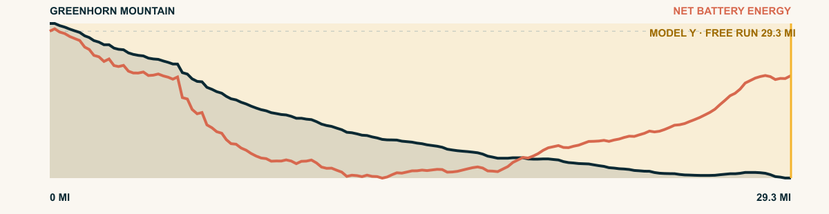
The highway leaves the shoulder of Greenhorn Mountain, threads ranch country, and descends toward the broad river valley near Florence. It is a quiet eastern-slope run with a long, clean finish.
For the 2026 Model Y Premium AWD, the model shows that the battery stays at or above its starting charge for 29.3 of 29.3 road miles. The highest energy surplus is 1.9 kWh. This equals about 6.9 miles at the EPA energy rate. The result shows how the road grade and speed can reduce net energy use.
- Battery-hold miles
- 29.3
- Route length
- 29.3 mi
- Share of route
- 100%
- Total descent
- 4,342 ft
- Peak surplus
- 1.9 kWh
- EPA-eq. banked
- 6.9 mi
#73 / WYOMING, USA
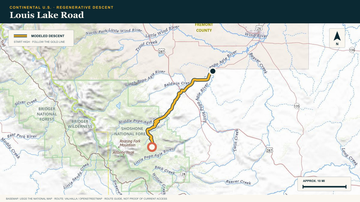
Louis Lake Road
Louis Lake Road → Hudson
WHAT THIS ROAD SHOWS
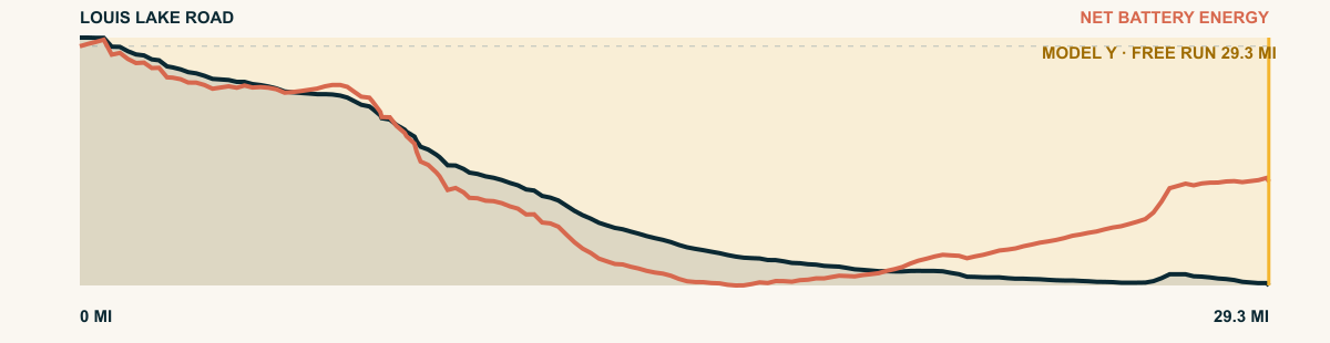
A narrow mountain road unwinds from the Wind River high country toward the sage basin. By the time the route reaches Hudson, granite walls have given way to a wide Wyoming sky.
For the 2026 Model Y Premium AWD, the model shows that the battery stays at or above its starting charge for 29.3 of 29.3 road miles. The highest energy surplus is 2.8 kWh. This equals about 10.2 miles at the EPA energy rate. The result shows how the road grade and speed can reduce net energy use.
- Battery-hold miles
- 29.3
- Route length
- 29.3 mi
- Share of route
- 100%
- Total descent
- 4,607 ft
- Peak surplus
- 2.8 kWh
- EPA-eq. banked
- 10.2 mi
#74 / UTAH, USA
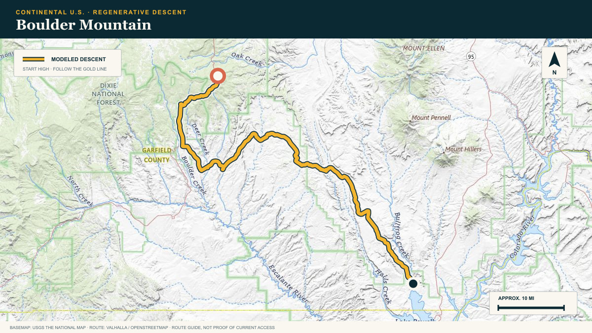
Boulder Mountain
Scenic Byway 12 → Burr Trail country
WHAT THIS ROAD SHOWS
The descent starts in spruce and aspen, then the world turns red. Long bends reveal the Henry Mountains and canyon country before the route reaches the open rock around Boulder and the Burr Trail.
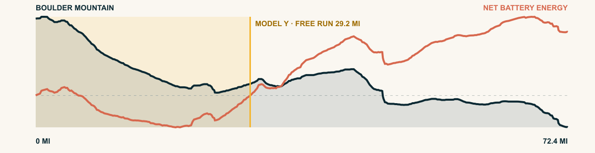
For the 2026 Model Y Premium AWD, the model shows that the battery stays at or above its starting charge for 29.2 of 72.4 road miles. The highest energy surplus is 1.9 kWh. This equals about 7 miles at the EPA energy rate. The result shows how the road grade and speed can reduce net energy use.
- Battery-hold miles
- 29.2
- Route length
- 72.4 mi
- Share of route
- 40%
- Total descent
- 8,390 ft
- Peak surplus
- 1.9 kWh
- EPA-eq. banked
- 7 mi
#75 / NAVAJO NATION, ARIZONA/NEW MEXICO, USA
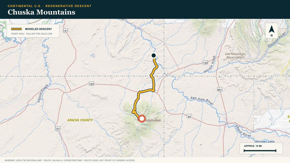
Chuska Mountains
Navajo Route 5034 off the Chuska crest
WHAT THIS ROAD SHOWS
A sandstone-capped forest range on the Navajo Nation. The route drops off the crest into the red valley country toward Canyon de Chelly’s drainage.
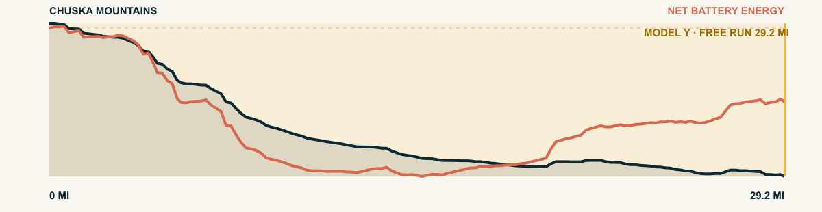
For the 2026 Model Y Premium AWD, the model shows that the battery stays at or above its starting charge for 29.2 of 29.2 road miles. The highest energy surplus is 3.1 kWh. This equals about 11.1 miles at the EPA energy rate. The result shows how the road grade and speed can reduce net energy use.
- Battery-hold miles
- 29.2
- Route length
- 29.2 mi
- Share of route
- 100%
- Total descent
- 4,927 ft
- Peak surplus
- 3.1 kWh
- EPA-eq. banked
- 11.1 mi
#76 / WYOMING, USA
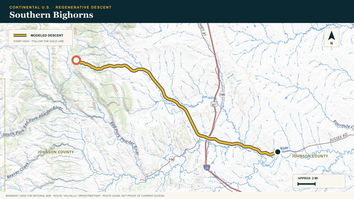
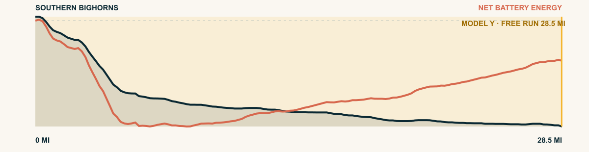
Southern Bighorns
Slip Road → Sussex Road
WHAT THIS ROAD SHOWS
There is no single postcard switchback here. The route works down from open mountain pasture through rolling foothills until the high country is only a line on the western horizon.
For the 2026 Model Y Premium AWD, the model shows that the battery stays at or above its starting charge for 28.5 of 28.5 road miles. The highest energy surplus is 2.7 kWh. This equals about 9.7 miles at the EPA energy rate. The result shows how the road grade and speed can reduce net energy use.
- Battery-hold miles
- 28.5
- Route length
- 28.5 mi
- Share of route
- 100%
- Total descent
- 3,726 ft
- Peak surplus
- 2.7 kWh
- EPA-eq. banked
- 9.7 mi
#77 / COLORADO, USA
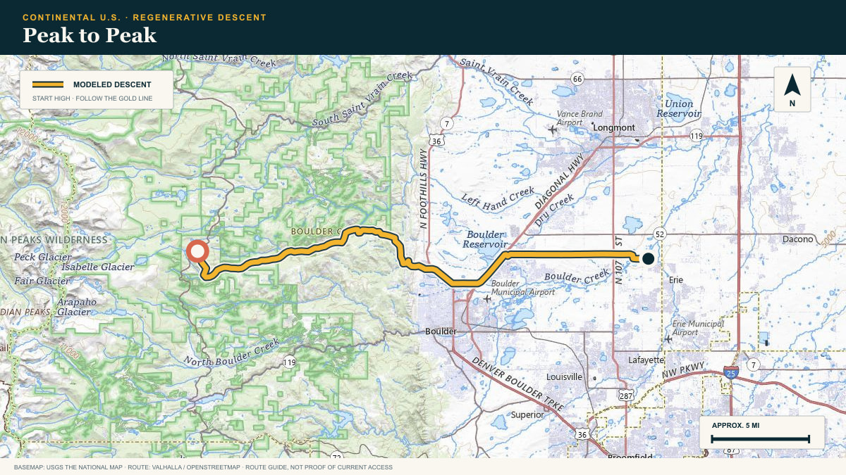
Peak to Peak
Peak to Peak Highway → Boulder plains
WHAT THIS ROAD SHOWS
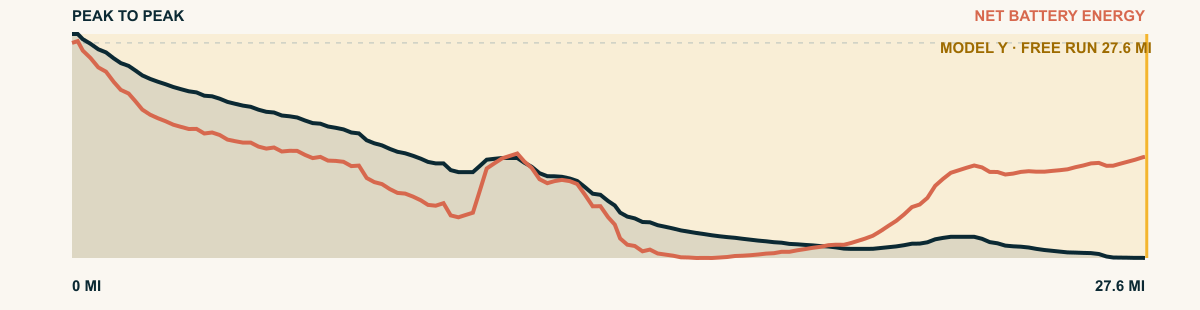
From the high road near Ward, the route leaves the Front Range in a sequence of forested shelves. Boulder County’s plains appear early and stay in view as the road gives back the last mountain miles.
For the 2026 Model Y Premium AWD, the model shows that the battery stays at or above its starting charge for 27.6 of 27.6 road miles. The highest energy surplus is 2.4 kWh. This equals about 8.8 miles at the EPA energy rate. The result shows how the road grade and speed can reduce net energy use.
- Battery-hold miles
- 27.6
- Route length
- 27.6 mi
- Share of route
- 100%
- Total descent
- 4,779 ft
- Peak surplus
- 2.4 kWh
- EPA-eq. banked
- 8.8 mi
#78 / UTAH, USA
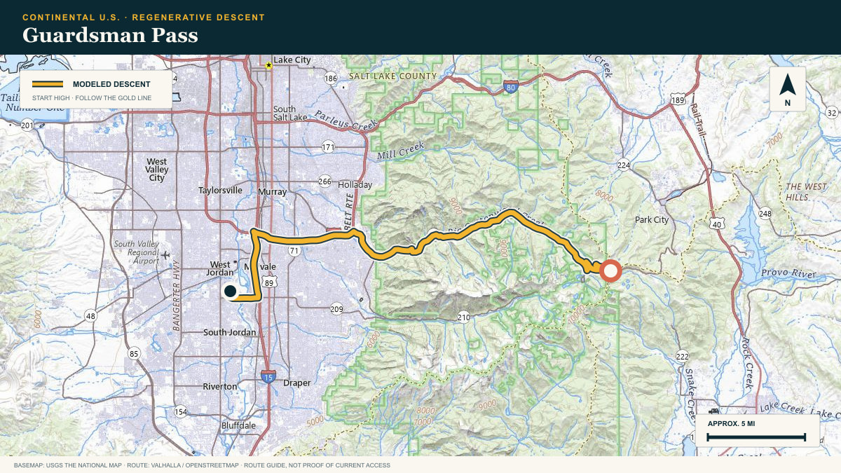
Guardsman Pass
Guardsman Pass Road → Salt Lake Valley
WHAT THIS ROAD SHOWS
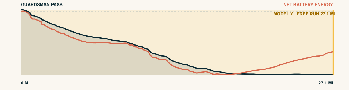
Aspen groves close around the road at the saddle, then Big Cottonwood Canyon takes over. The descent follows the creek out of the Wasatch and keeps rolling into the Salt Lake Valley.
For the 2026 Model Y Premium AWD, the model shows that the battery stays at or above its starting charge for 27.1 of 27.1 road miles. The highest energy surplus is 3.7 kWh. This equals about 13.4 miles at the EPA energy rate. The result shows how the road grade and speed can reduce net energy use.
- Battery-hold miles
- 27.1
- Route length
- 27.1 mi
- Share of route
- 100%
- Total descent
- 5,241 ft
- Peak surplus
- 3.7 kWh
- EPA-eq. banked
- 13.4 mi
#79 / WYOMING, USA
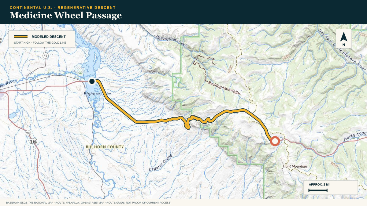
Medicine Wheel Passage
US-14A · Burgess Junction → Bighorn Basin
WHAT THIS ROAD SHOWS
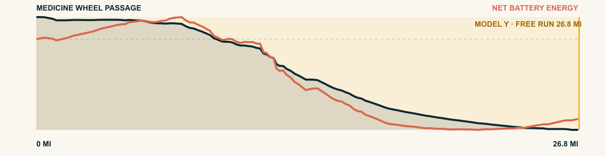
The alpine shelf ends almost at once. Below it, the highway draws broad switchbacks down a pale limestone wall and aims across the open Bighorn Basin.
For the 2026 Model Y Premium AWD, the model shows that the battery stays at or above its starting charge for 26.8 of 26.8 road miles. The highest energy surplus is 3.2 kWh. This equals about 11.7 miles at the EPA energy rate. The result shows how the road grade and speed can reduce net energy use.
- Battery-hold miles
- 26.8
- Route length
- 26.8 mi
- Share of route
- 100%
- Total descent
- 5,815 ft
- Peak surplus
- 3.2 kWh
- EPA-eq. banked
- 11.7 mi
#80 / UTAH, USA
Fishlake Plateau
Forest Road 640 → US-89
WHAT THIS ROAD SHOWS
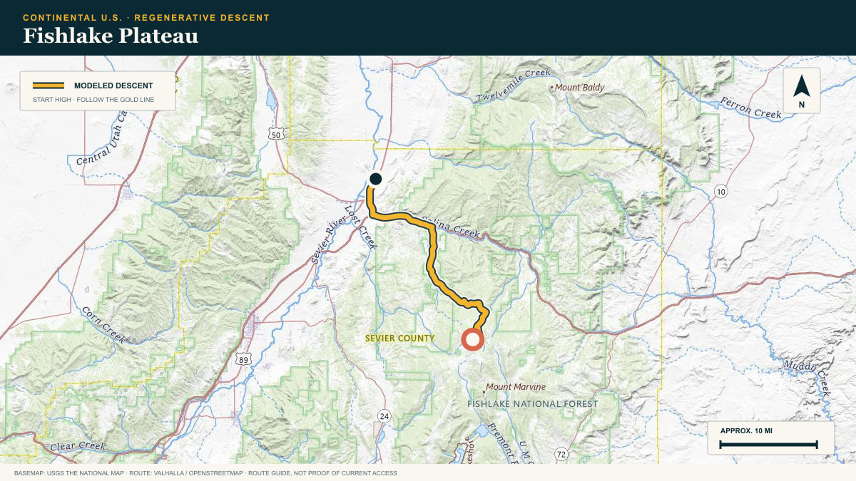
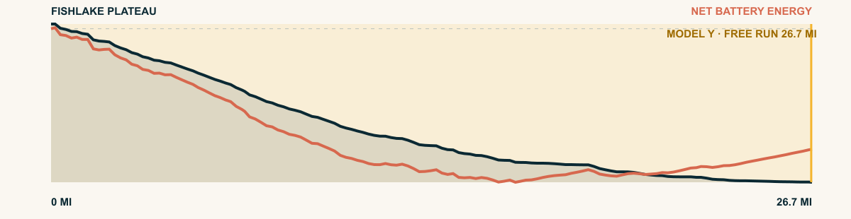
A forest road finds the edge of the plateau and follows drainage after drainage toward US-89. The grade is broken, but the accumulated drop keeps the energy ledger in gravity’s favor.
For the 2026 Model Y Premium AWD, the model shows that the battery stays at or above its starting charge for 26.7 of 26.7 road miles. The highest energy surplus is 3.3 kWh. This equals about 11.9 miles at the EPA energy rate. The result shows how the road grade and speed can reduce net energy use.
- Battery-hold miles
- 26.7
- Route length
- 26.7 mi
- Share of route
- 100%
- Total descent
- 5,099 ft
- Peak surplus
- 3.3 kWh
- EPA-eq. banked
- 11.9 mi
#81 / BRITISH COLUMBIA, CANADA
Kootenay Pass
BC-3 · Kootenay Pass → Creston
WHAT THIS ROAD SHOWS
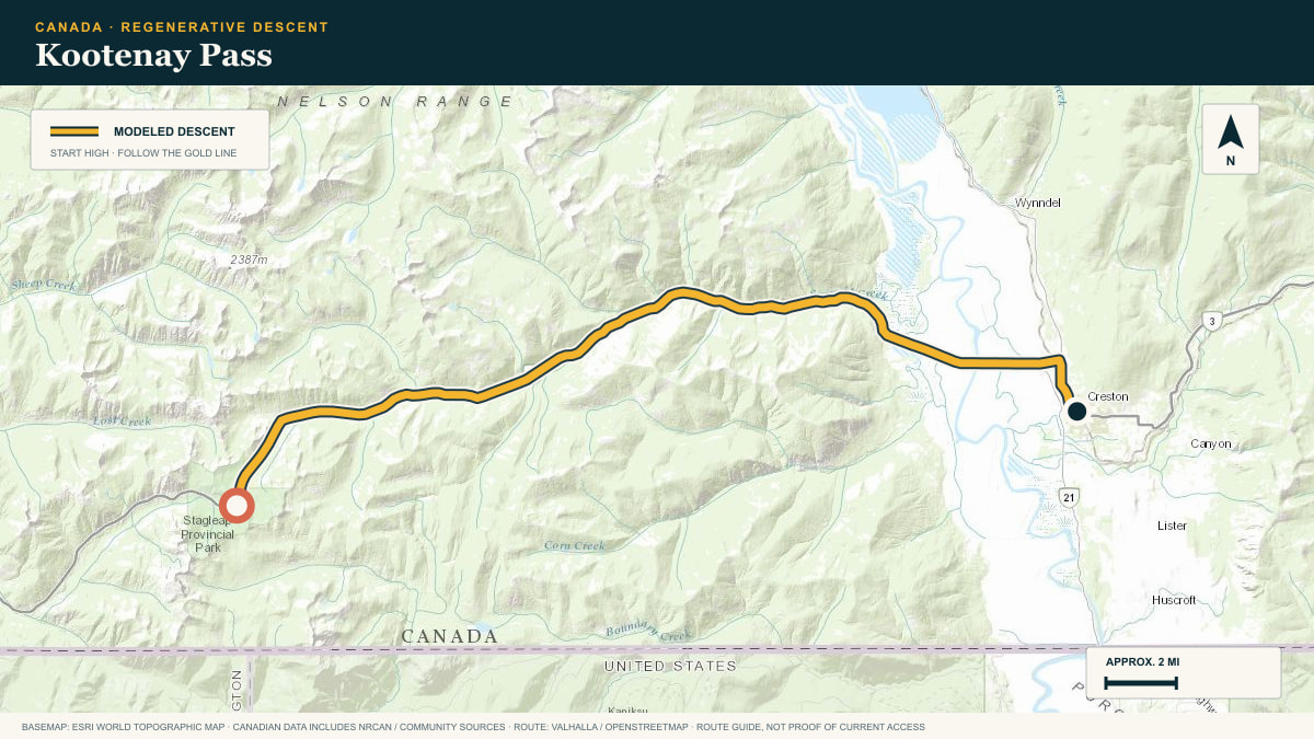
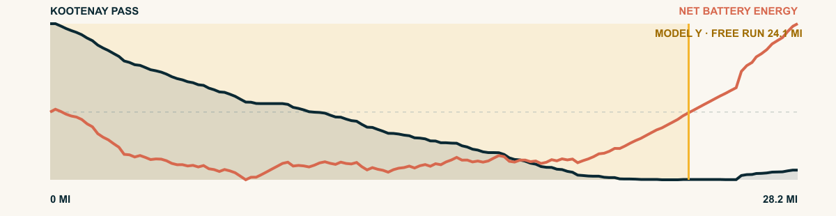
Highway 3 breaks east from the Kootenay Pass snow belt, drops beside fast creeks, and eventually opens onto the farms and wetlands of the Creston Valley. The grade relaxes, but gravity keeps paying for mile after mile.
For the 2026 Model Y Premium AWD, the model shows that the battery stays at or above its starting charge for 24.1 of 28.2 road miles. The highest energy surplus is 1 kWh. This equals about 3.7 miles at the EPA energy rate. The result shows how the road grade and speed can reduce net energy use.
- Battery-hold miles
- 24.1
- Route length
- 28.2 mi
- Share of route
- 85%
- Total descent
- 4,072 ft
- Peak surplus
- 1 kWh
- EPA-eq. banked
- 3.7 mi
#82 / BRITISH COLUMBIA, CANADA
Mount Baldy
McKinney Road · Mount Baldy → Oliver
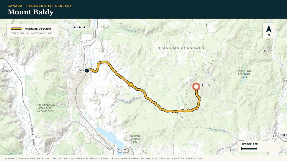
WHAT THIS ROAD SHOWS
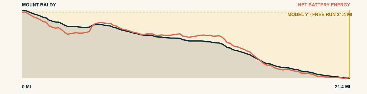
McKinney Road leaves the ski hill in forest and crosses a high bench. It then descends toward the grass, orchards, and vineyards near Oliver.
For the 2026 Model Y Premium AWD, the model shows that the battery stays at or above its starting charge for 21.4 of 21.4 road miles. The highest energy surplus is 3.1 kWh. This equals about 11.3 miles at the EPA energy rate. The result shows how the road grade and speed can reduce net energy use.
- Battery-hold miles
- 21.4
- Route length
- 21.4 mi
- Share of route
- 100%
- Total descent
- 4,829 ft
- Peak surplus
- 3.1 kWh
- EPA-eq. banked
- 11.3 mi
#83 / ALBERTA, CANADA
Sunwapta Pass
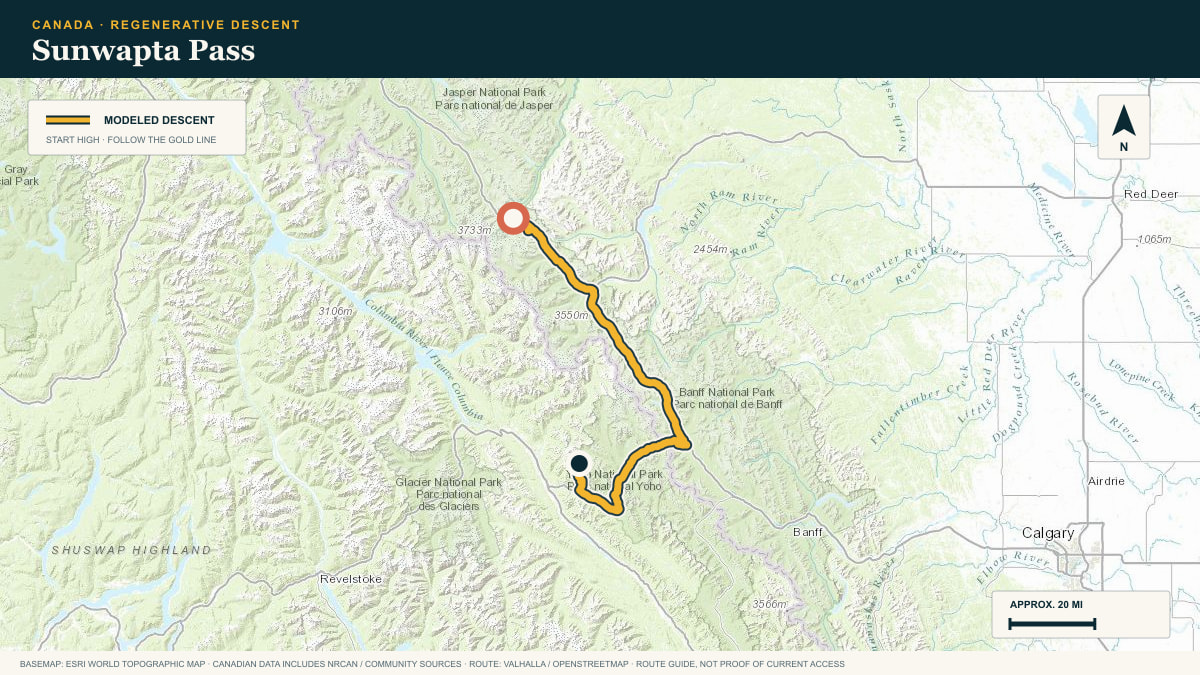
Icefields Parkway · Sunwapta Pass → Saskatchewan Crossing
WHAT THIS ROAD SHOWS
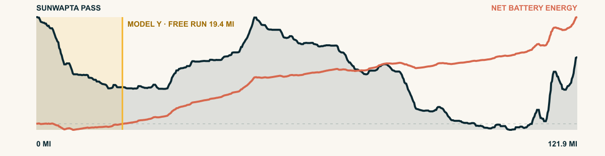
From the icefields, Highway 93 runs south beneath hanging glaciers and the great limestone walls of the Canadian Rockies. Valley after valley opens before the road reaches the North Saskatchewan.
For the 2026 Model Y Premium AWD, the model shows that the battery stays at or above its starting charge for 19.4 of 121.9 road miles. The highest energy surplus is 1 kWh. This equals about 3.6 miles at the EPA energy rate. The result shows how the road grade and speed can reduce net energy use.
- Battery-hold miles
- 19.4
- Route length
- 121.9 mi
- Share of route
- 16%
- Total descent
- 7,188 ft
- Peak surplus
- 1 kWh
- EPA-eq. banked
- 3.6 mi
#84 / BRITISH COLUMBIA, CANADA
Apex Mountain
Apex Mountain Road · Apex Resort → Penticton
WHAT THIS ROAD SHOWS
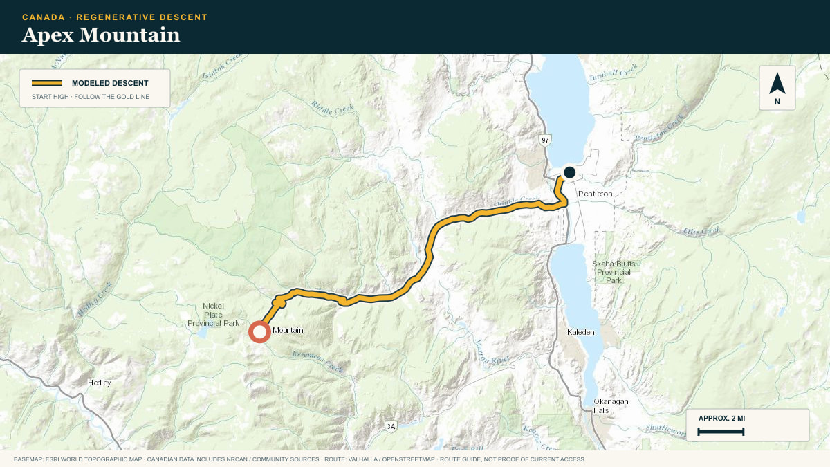
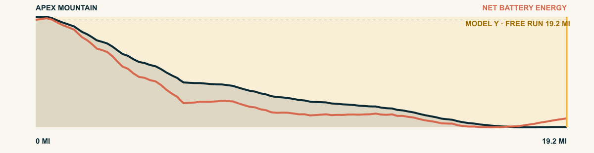
Apex Mountain Road falls out of lodgepole pine, joins Green Mountain Road, and follows the folds of the valley toward Penticton. The last miles trade forest for wide Okanagan light.
For the 2026 Model Y Premium AWD, the model shows that the battery stays at or above its starting charge for 19.2 of 19.2 road miles. The highest energy surplus is 3.5 kWh. This equals about 12.8 miles at the EPA energy rate. The result shows how the road grade and speed can reduce net energy use.
- Battery-hold miles
- 19.2
- Route length
- 19.2 mi
- Share of route
- 100%
- Total descent
- 4,557 ft
- Peak surplus
- 3.5 kWh
- EPA-eq. banked
- 12.8 mi
#85 / VANCOUVER ISLAND, BRITISH COLUMBIA, CANADA
Mount Washington
Strathcona Parkway · Mount Washington → Courtenay
WHAT THIS ROAD SHOWS
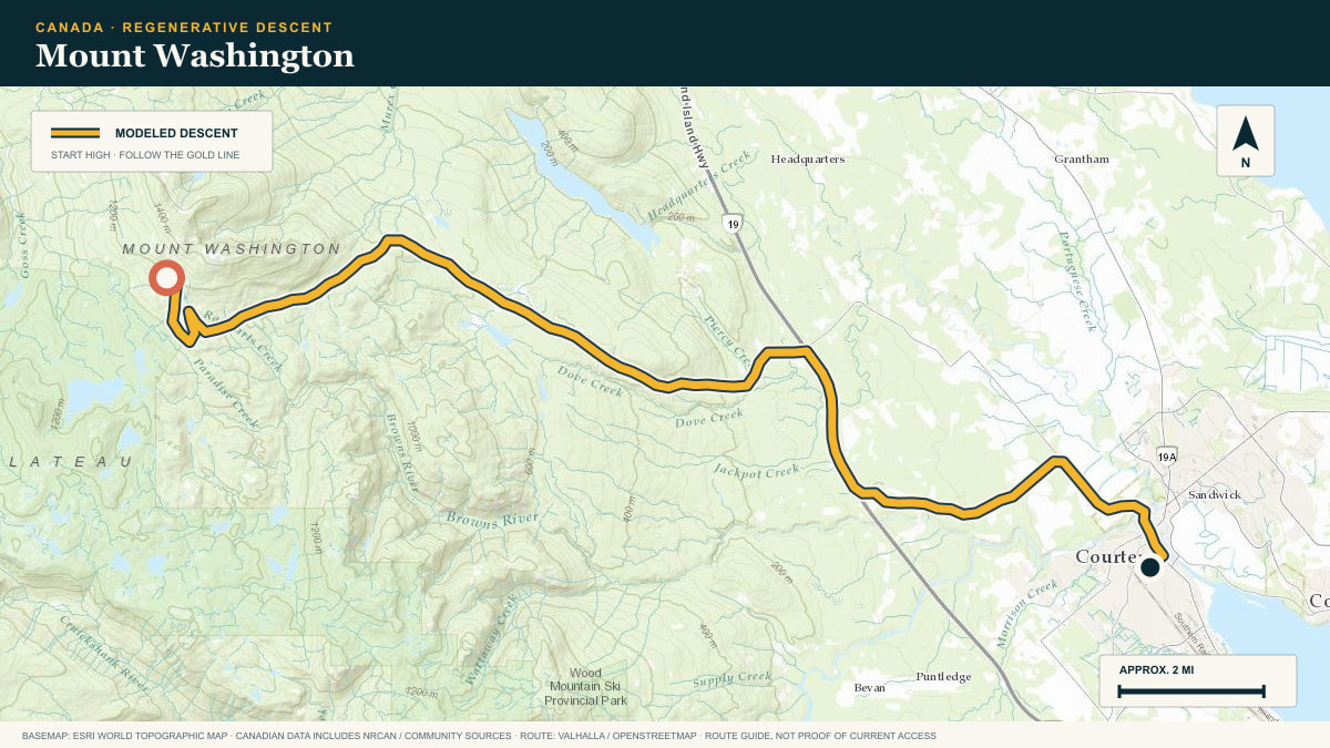
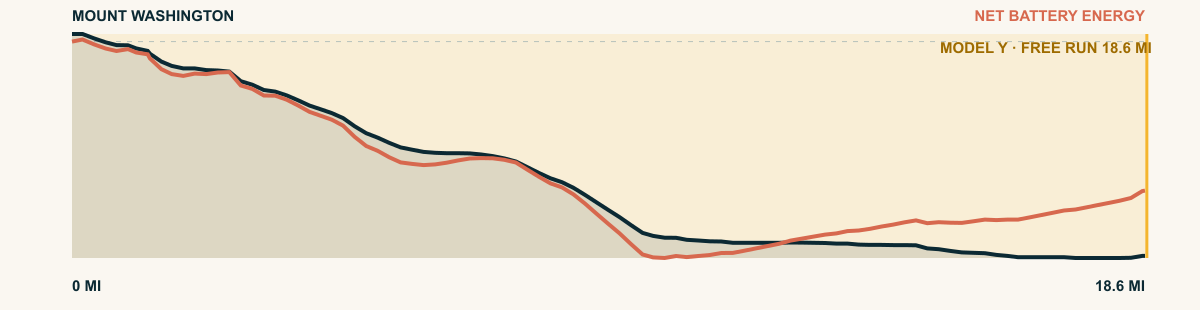
The parkway leaves the resort and descends through silver fir and hemlock. It ends near the farms and salt air of the Comox Valley.
For the 2026 Model Y Premium AWD, the model shows that the battery stays at or above its starting charge for 18.6 of 18.6 road miles. The highest energy surplus is 2.9 kWh. This equals about 10.4 miles at the EPA energy rate. The result shows how the road grade and speed can reduce net energy use.
- Battery-hold miles
- 18.6
- Route length
- 18.6 mi
- Share of route
- 100%
- Total descent
- 3,835 ft
- Peak surplus
- 2.9 kWh
- EPA-eq. banked
- 10.4 mi
#86 / BRITISH COLUMBIA, CANADA
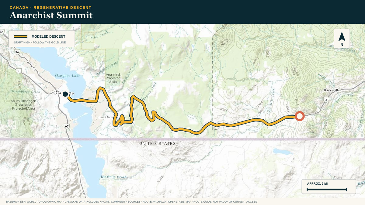
Anarchist Summit
Crowsnest Highway · Anarchist Summit → Osoyoos
WHAT THIS ROAD SHOWS
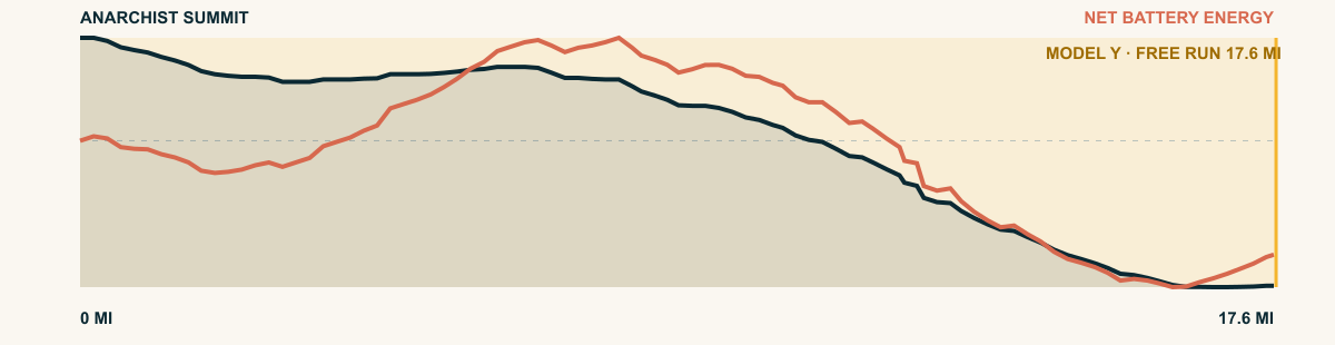
The bench falls away quickly. Highway 3 descends almost one kilometre through switchbacks. The road shows Osoyoos Lake, vineyards, and the striped border hills.
For the 2026 Model Y Premium AWD, the model shows that the battery stays at or above its starting charge for 17.6 of 17.6 road miles. The highest energy surplus is 1.1 kWh. This equals about 4.1 miles at the EPA energy rate. The result shows how the road grade and speed can reduce net energy use.
- Battery-hold miles
- 17.6
- Route length
- 17.6 mi
- Share of route
- 100%
- Total descent
- 3,314 ft
- Peak surplus
- 1.1 kWh
- EPA-eq. banked
- 4.1 mi
#87 / BRITISH COLUMBIA, CANADA
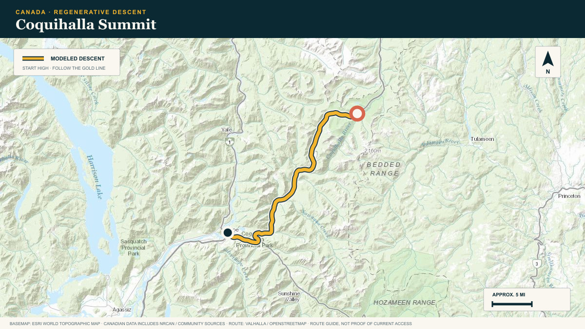
Coquihalla Summit
BC-5 · Coquihalla Summit → Hope
WHAT THIS ROAD SHOWS
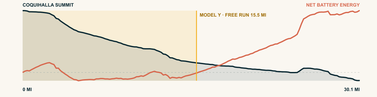
From the divide, the Coquihalla commits west. Broad freeway curves sweep past avalanche paths and granite shoulders, then follow the Coquihalla River into the wet green walls above Hope.
For the 2026 Model Y Premium AWD, the model shows that the battery stays at or above its starting charge for 15.5 of 30.1 road miles. The highest energy surplus is 0.3 kWh. This equals about 1.1 miles at the EPA energy rate. The result shows how the road grade and speed can reduce net energy use.
- Battery-hold miles
- 15.5
- Route length
- 30.1 mi
- Share of route
- 51%
- Total descent
- 4,180 ft
- Peak surplus
- 0.3 kWh
- EPA-eq. banked
- 1.1 mi
#88 / BRITISH COLUMBIA, CANADA
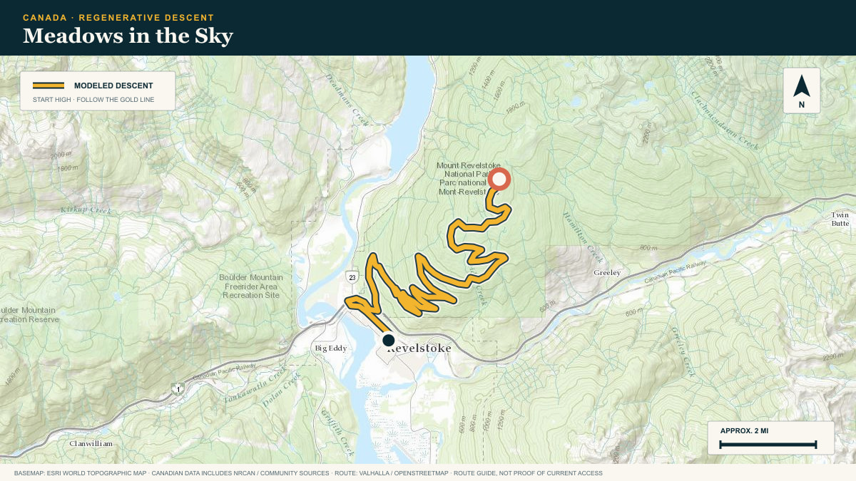
Meadows in the Sky
Meadows in the Sky Parkway · Balsam Lake → Revelstoke
WHAT THIS ROAD SHOWS
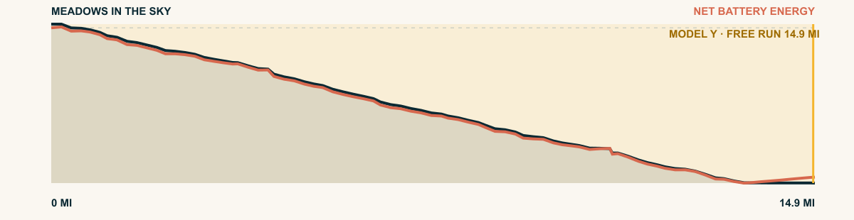
A narrow park road leaves the flower meadows of Mount Revelstoke. It descends through spruce, fir, and inland rainforest to the Columbia Valley.
For the 2026 Model Y Premium AWD, the model shows that the battery stays at or above its starting charge for 14.9 of 14.9 road miles. The highest energy surplus is 4.2 kWh. This equals about 15.4 miles at the EPA energy rate. The result shows how the road grade and speed can reduce net energy use.
- Battery-hold miles
- 14.9
- Route length
- 14.9 mi
- Share of route
- 100%
- Total descent
- 4,698 ft
- Peak surplus
- 4.2 kWh
- EPA-eq. banked
- 15.4 mi
#89 / BRITISH COLUMBIA, CANADA
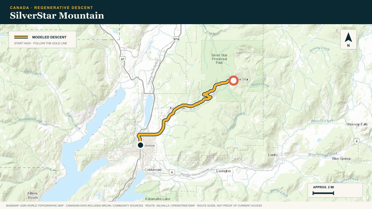
SilverStar Mountain
Silver Star Road · SilverStar → Vernon
WHAT THIS ROAD SHOWS
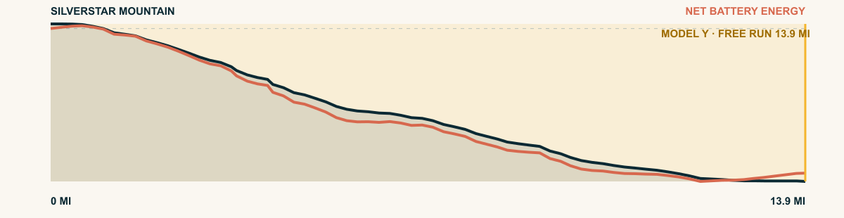
Silver Star Road descends steadily from the alpine village. It passes ranchland on the lower bench and ends near Vernon.
For the 2026 Model Y Premium AWD, the model shows that the battery stays at or above its starting charge for 13.9 of 13.9 road miles. The highest energy surplus is 3.3 kWh. This equals about 12 miles at the EPA energy rate. The result shows how the road grade and speed can reduce net energy use.
- Battery-hold miles
- 13.9
- Route length
- 13.9 mi
- Share of route
- 100%
- Total descent
- 4,012 ft
- Peak surplus
- 3.3 kWh
- EPA-eq. banked
- 12 mi
#90 / BRITISH COLUMBIA, CANADA
Sasquatch Mountain
Hemlock Valley Road · Sasquatch Mountain → Harrison Mills
WHAT THIS ROAD SHOWS
Hemlock Valley Road winds down through wet Coast Mountain forest, crosses creek gullies, and finally reaches the broad, low farmland beside the Fraser River.
For the 2026 Model Y Premium AWD, the model shows that the battery stays at or above its starting charge for 12.8 of 12.8 road miles. The highest energy surplus is 3 kWh. This equals about 11 miles at the EPA energy rate. The result shows how the road grade and speed can reduce net energy use.
- Battery-hold miles
- 12.8
- Route length
- 12.8 mi
- Share of route
- 100%
- Total descent
- 3,179 ft
- Peak surplus
- 3 kWh
- EPA-eq. banked
- 11 mi
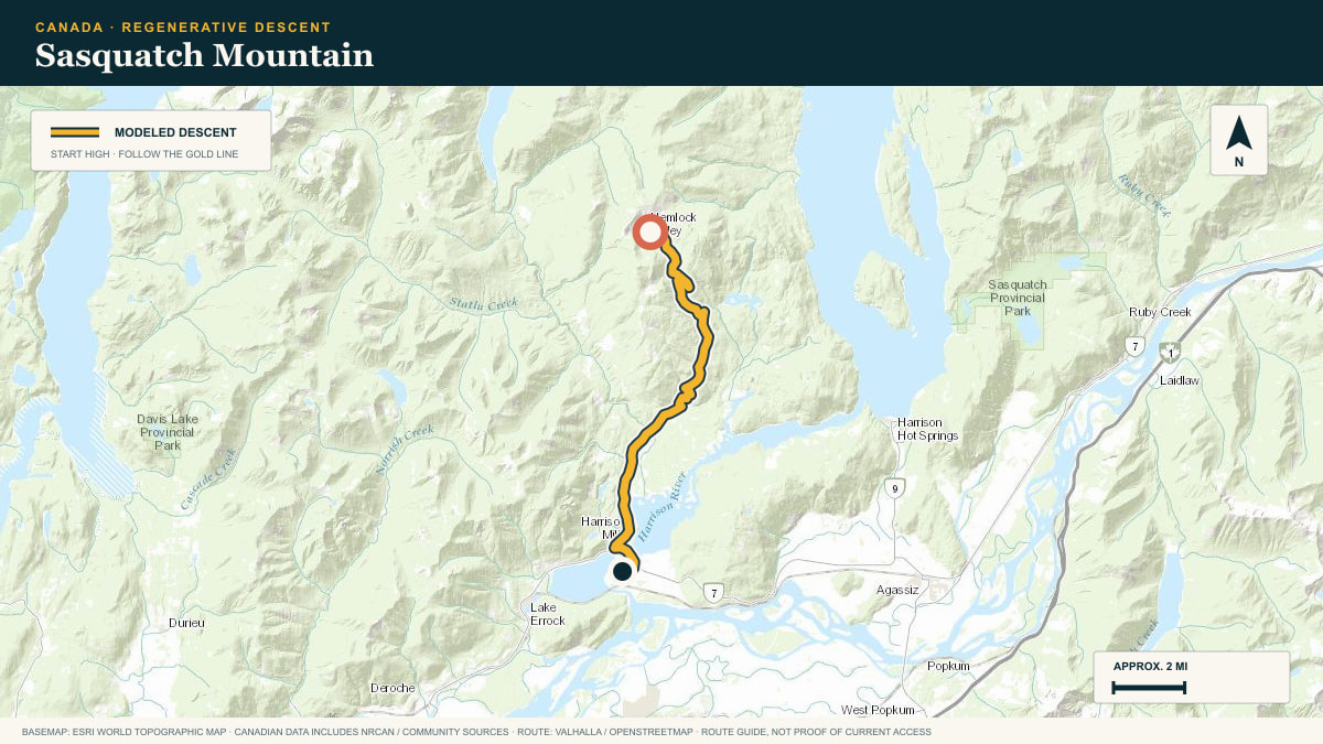
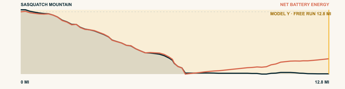
#91 / BRITISH COLUMBIA, CANADA
Red Mountain
BC-22 / Red Mountain Road · Rossland → Trail
WHAT THIS ROAD SHOWS
From Rossland, Highway 22 falls through a steep, settled mountain corridor. Houses cling to the grade before the road reaches the Columbia River at Trail.
For the 2026 Model Y Premium AWD, the model shows that the battery stays at or above its starting charge for 12.2 of 12.2 road miles. The highest energy surplus is 4.8 kWh. This equals about 17.6 miles at the EPA energy rate. The result shows how the road grade and speed can reduce net energy use.
- Battery-hold miles
- 12.2
- Route length
- 12.2 mi
- Share of route
- 100%
- Total descent
- 5,003 ft
- Peak surplus
- 4.8 kWh
- EPA-eq. banked
- 17.6 mi
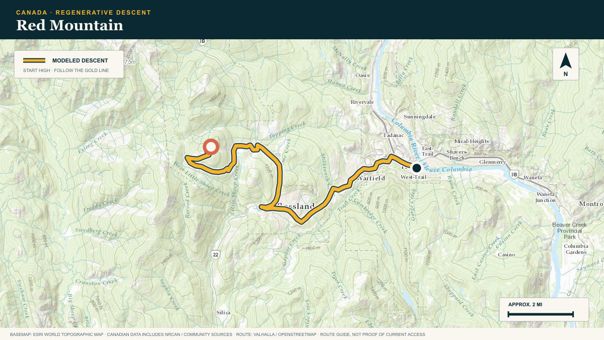
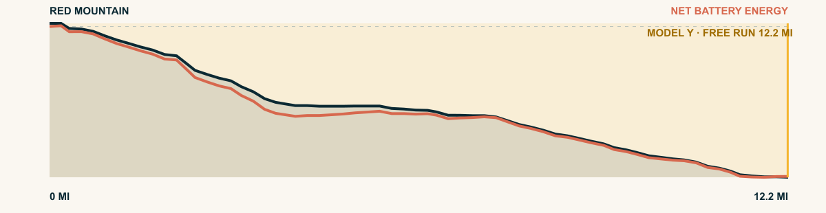
#92 / BRITISH COLUMBIA, CANADA
Cypress Bowl
Cypress Bowl Road · Hollyburn Ridge → West Vancouver
WHAT THIS ROAD SHOWS
A short descent with an enormous view. The road leaves the ski area, rounds the shoulder of Hollyburn Ridge, and repeatedly opens windows onto Vancouver and the Salish Sea before meeting the city grid.
For the 2026 Model Y Premium AWD, the model shows that the battery stays at or above its starting charge for 10.9 of 10.9 road miles. The highest energy surplus is 1.9 kWh. This equals about 6.9 miles at the EPA energy rate. The result shows how the road grade and speed can reduce net energy use.
- Battery-hold miles
- 10.9
- Route length
- 10.9 mi
- Share of route
- 100%
- Total descent
- 2,638 ft
- Peak surplus
- 1.9 kWh
- EPA-eq. banked
- 6.9 mi
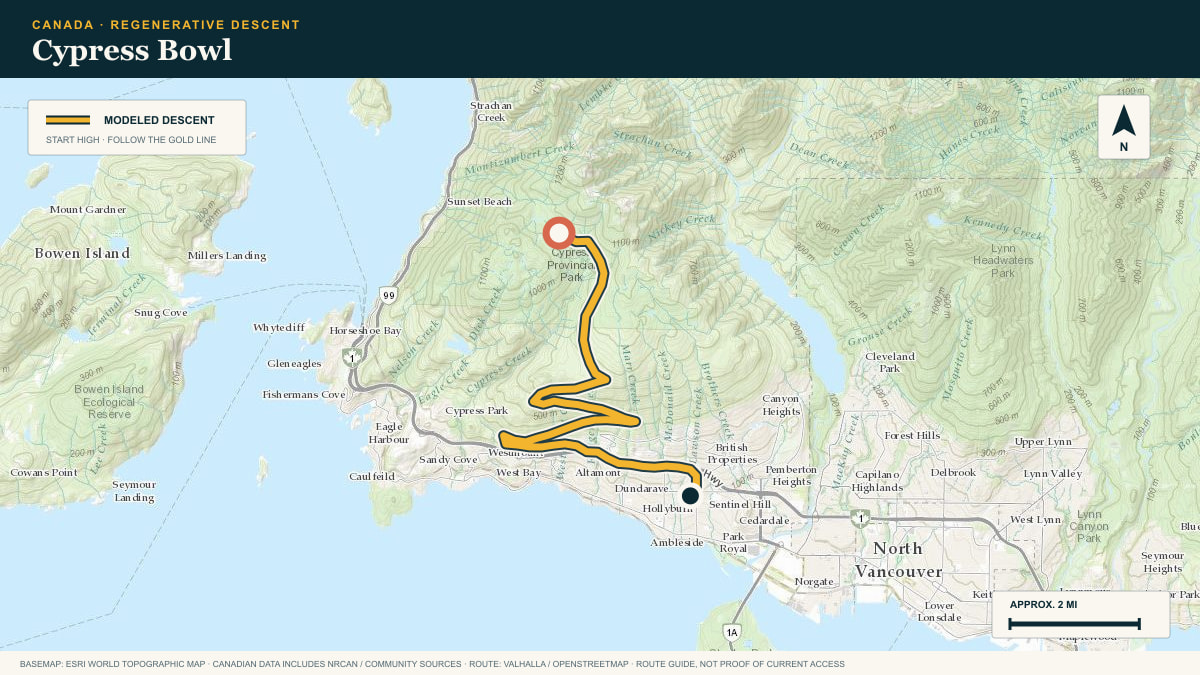
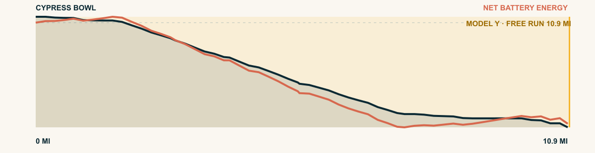
#93 / BRITISH COLUMBIA, CANADA
Mount Seymour
Mount Seymour Parkway · ski area → North Vancouver
WHAT THIS ROAD SHOWS
A compact Coast Mountain descent begins among hemlock and ski runs, then drops through deep forest until Burrard Inlet and Vancouver’s street grid appear below.
For the 2026 Model Y Premium AWD, the model shows that the battery stays at or above its starting charge for 10.4 of 10.4 road miles. The highest energy surplus is 2.9 kWh. This equals about 10.6 miles at the EPA energy rate. The result shows how the road grade and speed can reduce net energy use.
- Battery-hold miles
- 10.4
- Route length
- 10.4 mi
- Share of route
- 100%
- Total descent
- 3,310 ft
- Peak surplus
- 2.9 kWh
- EPA-eq. banked
- 10.6 mi
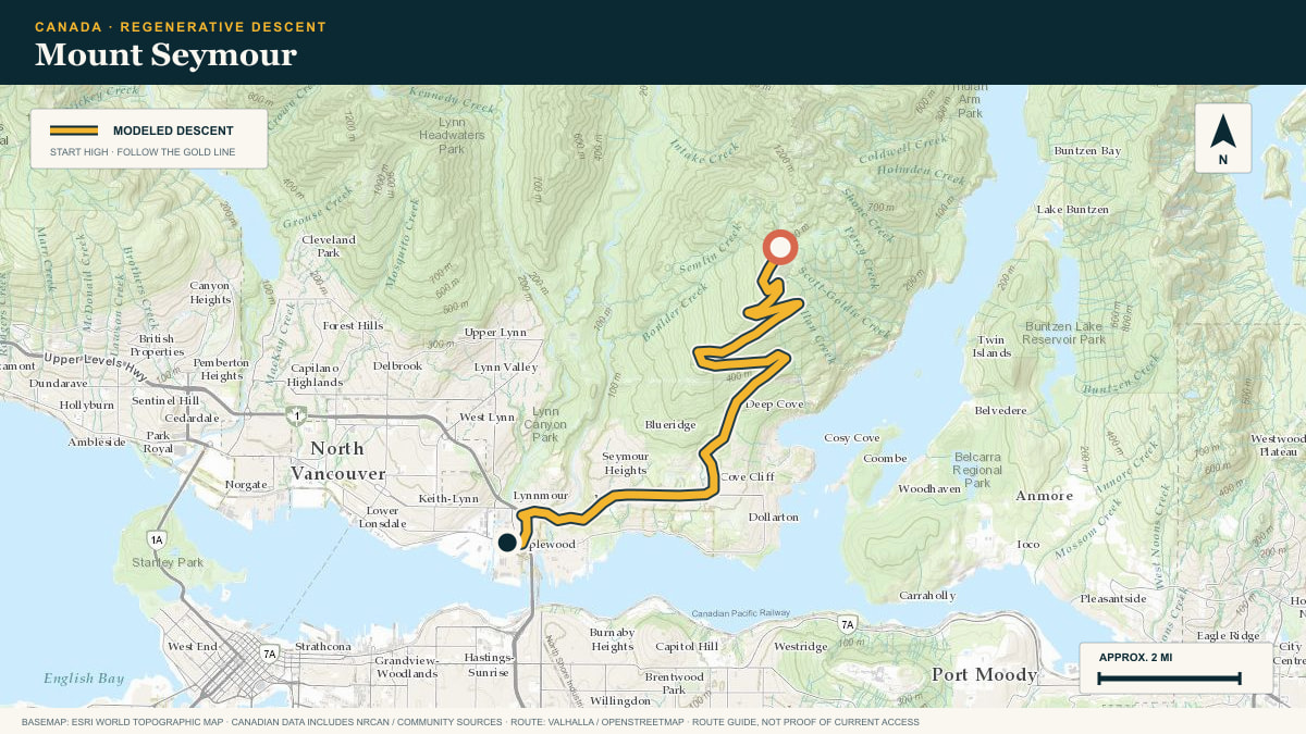
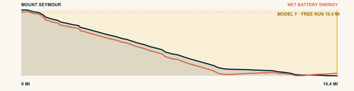
#94 / BRITISH COLUMBIA, CANADA
Kicking Horse Mountain
Kicking Horse Trail · Resort base → Golden
WHAT THIS ROAD SHOWS
This one is brief and decisive: the access road unwinds from the ski base, crosses open benches above the Columbia, and drops directly into Golden.
For the 2026 Model Y Premium AWD, the model shows that the battery stays at or above its starting charge for 7.5 of 7.5 road miles. The highest energy surplus is 1.1 kWh. This equals about 4.2 miles at the EPA energy rate. The result shows how the road grade and speed can reduce net energy use.
- Battery-hold miles
- 7.5
- Route length
- 7.5 mi
- Share of route
- 100%
- Total descent
- 1,526 ft
- Peak surplus
- 1.1 kWh
- EPA-eq. banked
- 4.2 mi
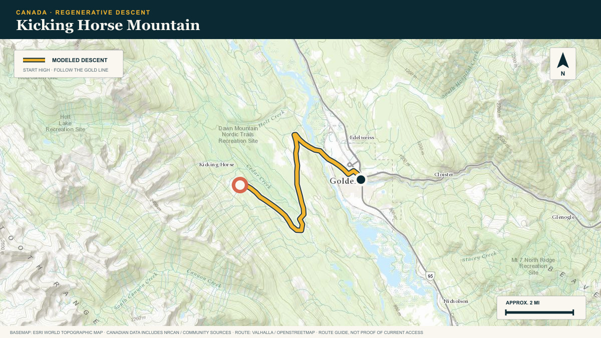
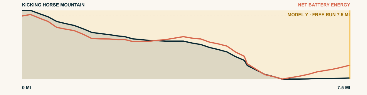
#95 / BRITISH COLUMBIA, CANADA
Sun Peaks
Sun Peaks Road · Sun Peaks → Kamloops
WHAT THIS ROAD SHOWS
From the village, the road follows the narrow Louis Creek valley, then Highway 5 turns south. Forest thins, grassland takes over, and the Thompson Valley opens below.
For the 2026 Model Y Premium AWD, the model shows that the battery stays at or above its starting charge for 7.3 of 35.9 road miles. The highest energy surplus is 1 kWh. This equals about 3.8 miles at the EPA energy rate. The result shows how the road grade and speed can reduce net energy use.
- Battery-hold miles
- 7.3
- Route length
- 35.9 mi
- Share of route
- 20%
- Total descent
- 3,904 ft
- Peak surplus
- 1 kWh
- EPA-eq. banked
- 3.8 mi
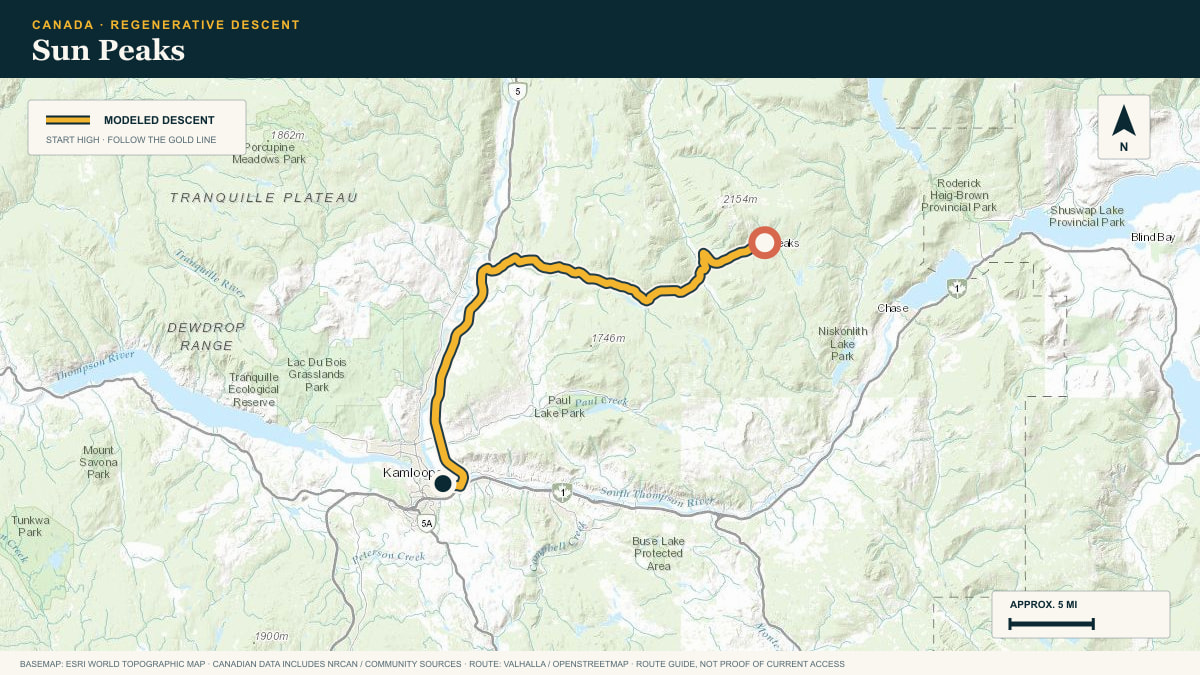
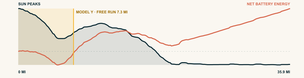
#96 / BRITISH COLUMBIA, CANADA
Pennask Summit
Okanagan Connector · Pennask Summit → Merritt
WHAT THIS ROAD SHOWS
BC-97C travels west from the high lakes near Pennask. It crosses open plateau and then descends through the Nicola Valley toward Merritt.
For the 2026 Model Y Premium AWD, the model shows that the battery stays at or above its starting charge for 6.6 of 60 road miles. The highest energy surplus is 0.4 kWh. This equals about 1.4 miles at the EPA energy rate. The result shows how the road grade and speed can reduce net energy use.
- Battery-hold miles
- 6.6
- Route length
- 60 mi
- Share of route
- 11%
- Total descent
- 6,463 ft
- Peak surplus
- 0.4 kWh
- EPA-eq. banked
- 1.4 mi
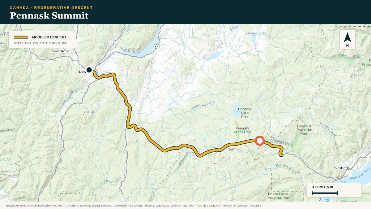
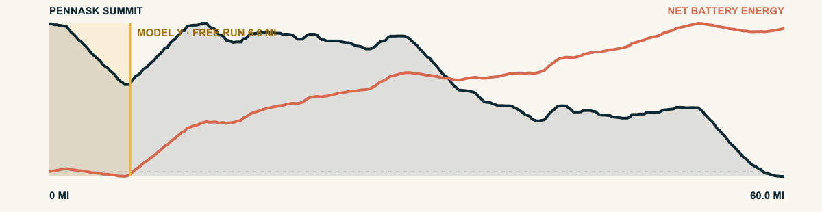
#97 / BRITISH COLUMBIA, CANADA
Rogers Pass
Trans-Canada Highway · Rogers Pass → Revelstoke
WHAT THIS ROAD SHOWS
The Trans-Canada leaves the pass beneath avalanche sheds, follows the Illecillewaet through Glacier National Park, and trades icefields for cedar forest on the long run into Revelstoke.
For the 2026 Model Y Premium AWD, the model shows that the battery stays at or above its starting charge for 5.1 of 40.4 road miles. The highest energy surplus is 0.3 kWh. This equals about 1 miles at the EPA energy rate. The result shows how the road grade and speed can reduce net energy use.
- Battery-hold miles
- 5.1
- Route length
- 40.4 mi
- Share of route
- 13%
- Total descent
- 3,327 ft
- Peak surplus
- 0.3 kWh
- EPA-eq. banked
- 1 mi
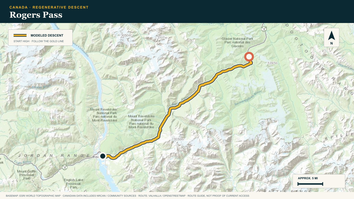
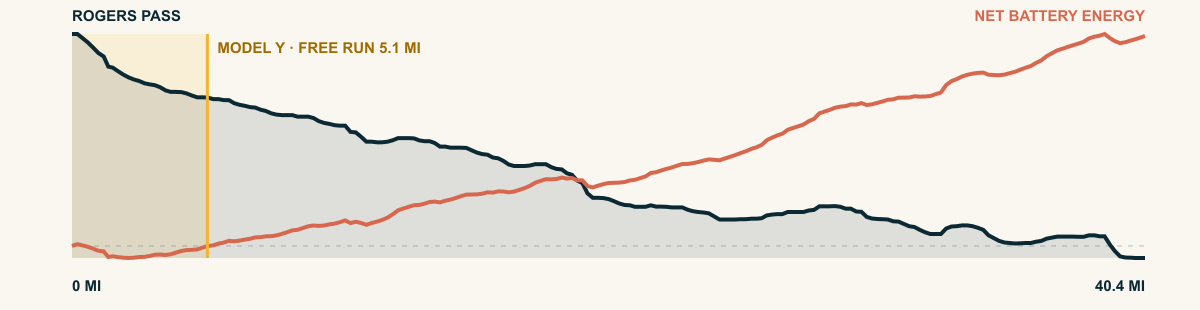
#98 / ALBERTA, CANADA
Mount Norquay
Mount Norquay Scenic Drive · Norquay → Banff
WHAT THIS ROAD SHOWS
The compact park road leaves the ski area, hooks across the face of the mountain, and returns to the Trans-Canada just above Banff. Every bend rearranges the Bow Valley below.
For the 2026 Model Y Premium AWD, the model shows that the battery stays at or above its starting charge for 3.4 of 3.4 road miles. The highest energy surplus is 1 kWh. This equals about 3.5 miles at the EPA energy rate. The result shows how the road grade and speed can reduce net energy use.
- Battery-hold miles
- 3.4
- Route length
- 3.4 mi
- Share of route
- 100%
- Total descent
- 1,017 ft
- Peak surplus
- 1 kWh
- EPA-eq. banked
- 3.5 mi